Showing posts with label Hiking Ireland. Show all posts

Friday 31 January 2020

January 2020..Out and about.

Sunday January 12th;

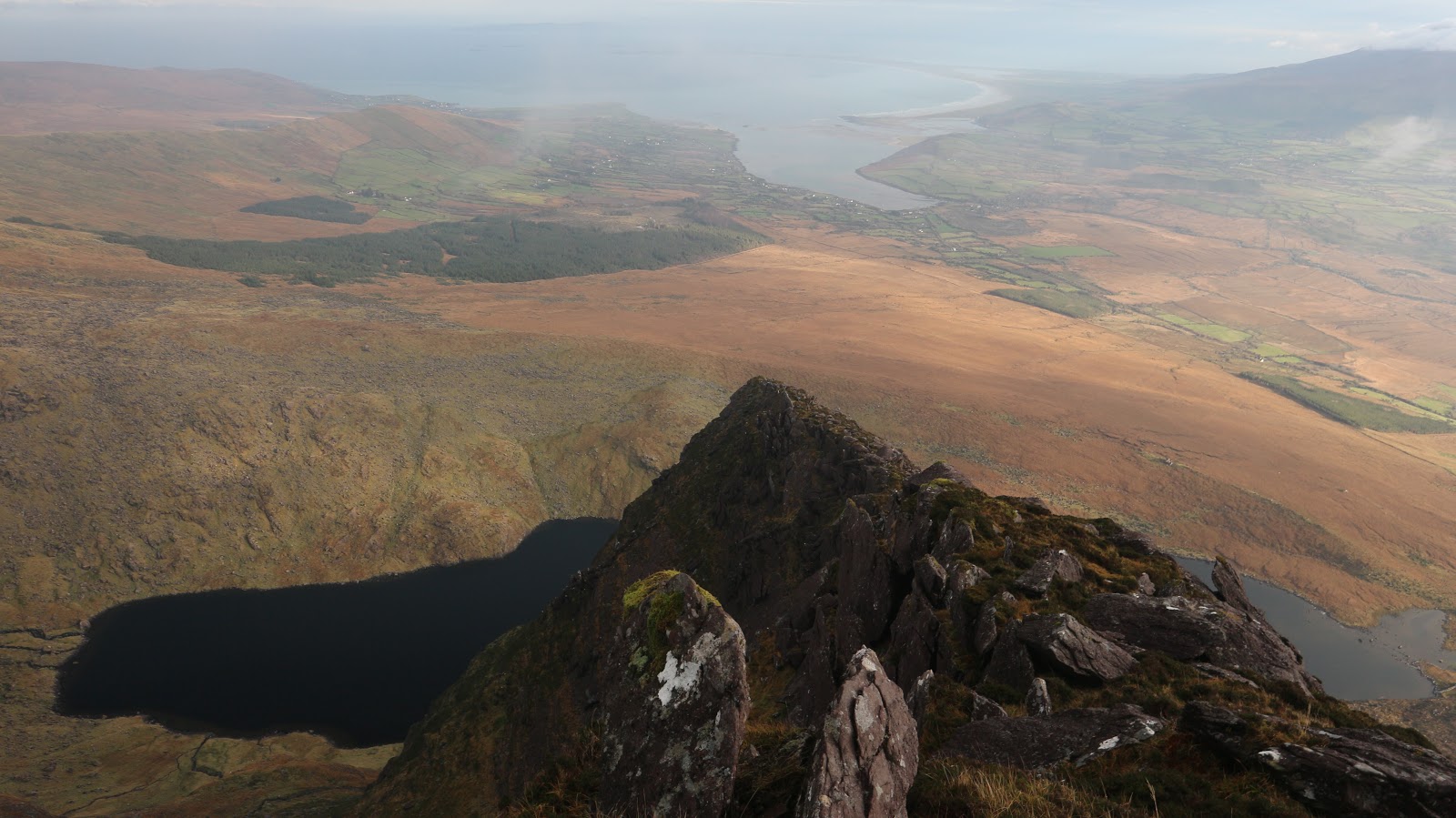
After the usual excesses over Christmas I was a little lethargic in getting back to the mountains. I put this to rights by visiting the Reeks to get some mountain miles in. It was a chilly but dry morning and while not a blue sky day there were some breaks in the clouds and I was hopeful of getting some views. I decided to head up Carrauntoohil first and opted for O'Sheas Gully for a change. It had been ages since I had last climbed this route (probably because it is a bit of a slog) so I was looking forward to doing it today.
There had been a lot of rain and the waterfalls in Coumeenoughter were lovely. The spectacular mountain scenery was made all the more beautiful by some bursts of sunlight as I rose higher. The interminable slog from the small lake in the upper coum to the top of the gully was a bummer but it passed OK and soon all that was left was the 400 ft climb to the summit. The summit itself was still in the grip of winter and quite atmospheric. Unfortunately the clear patches of sky had given way to thick cloud and views were limited to say the least. Still I was enjoying myself and relishing the day. I left the usual summit throng behind and set off towards the top of "the ladder". Once here I decided to continue as far as The Bone as this would make it a worthy effort. Usually once past Cnoc na Toinne it is seldom you meet many but today there were quite a few people on the East Reeks. Here the views once again opened up but I cold see that a snow squall was coming my way. In the stiff chill wind it soon arrived and passed and the view to the east of the cloud and mountains was a delight .After the stiff climb to Cnoc an Cuillian it is an easy stroll to reach the elegant top of Maolain Bui. The descent from here is long but straightforward and before too long I was striding back towards Cronins Yard.
15 kilometres covered..1200 metres climbed in 4 hours 20mins.

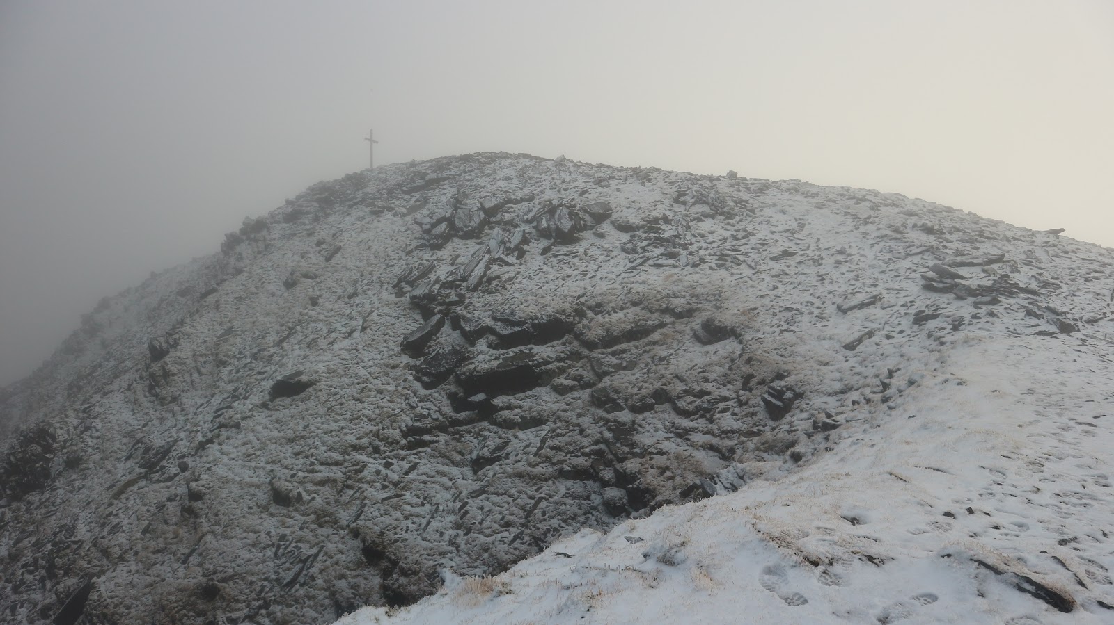
Still in winters grip

A bit of weather on the way

Sunday January 19th;

I was in the middle of a week of night work and to be honest pretty fatigued but a great forecast for today was too good to pass up so I headed directly from work to the Galtees. The Reeks had had a dusting of snow and I was tempted to head west but time constraints made the Galtees more attractive. It was -4 as I parked the car in Glengarra Wood. Still dark when I arrived the first thing I saw was a couple of deer heading for cover out of the glare of the headlights. The cold air invigorated me as I readied and set off in the still gloom. These woods are a delight in the spring when the many fine specimen trees are complimented by lots of mature rhododendron trees. It was still pleasant to walk easily up through the forest until after a few kilometres more open ground is reached and the gentle mountain slopes were revealed, bathed in the rosy dawn glow.
What a joy it was to be out on the hills on such a beautiful morning. Despite the lack of sleep there was nowhere else I would rather have been. One surprise was the complete lack of snow. I guess nothing in the way of precipitation had happened over the previous few days. It was still beautiful though and with the normally boggy ground frozen solid progress was a little easier. I headed first for Green and which is easily reached via the long spur that drops to the south. It was a delight to stop occasionally and admire the view across the frosted valley to where the Knockmealdowns rose. Further east the Comeraghs could be admired and once on the crest of the spur Slievenamon and even the Blackstairs Mountains were sharp and clear. Once on the broad 800 metre plus summit the views were even more expansive and across the frozen valley the Silvermine Mts and the central plain of the country could be seen.


The going after this was super easy as I passed O'Loughlans Castle and eventually dropped down to the col under Galtybeg. Normally mucky and boggy ground was frozen solid and the biggest issue was avoiding icy patches. The pull to the top of Galtybeg went well and before long I was dropping to the col above Lough Diheen and setting off up for the frozen summit of Galtymór. A wispy cloud clung to the summit and obscured any views so I didn't delay in turning and retracing my steps back from the top. The super hard frozen turf made for tricky going in places and sure enough I had a little spill which was quite painful on the unforgiving ground. Once down a little further I reachd slightly longer grass that made for swift easy progress. I skirted under the south flank of Galtybeg before briefly joining the "Black Road" and then dropping easily southeast and entering the wood again. An easy few kilometres through the trees saw me reach the car 5 hours after setting off. It was a beautiful crisp refreshing day out...just the ticket.

I hadn't been completely idle on other days. I have tried to to get out on the bike when the weather allows and there is a nice 52 kilometre circuit I have managed to fit in a couple of times this month that gives around 600 metres of ascent. Running is a bit of a struggle as my hamstrings are painful after trying to do some speed training. Maybe I'm getting too old for this sh#t.

Thursday and Friday January 23rd&24th;

After a week of nights I took advantage of my few days off to head back to Killarney and stay overnight so that I could get two good outings in.
First up came a cycle. Arriving in the town at midday I booked into my accommodation and once I was suited up I set off on the bike. It was quite foggy at home and remained so until I was about 5 miles from the town. It was a relief to see that, in Killarney, while the cloud was quite low down things at ground level were quite clear so it would be safe to go for a ride. I had plenty of time to fit a decent outing in and it was all down to how I was feeling en route that would decide how far I would go. The route I had in mind was to do a circuit of The Reeks which wouls give a round over 80 kilometres long and would pass over the Ballaghbeama Gap. If I was struggling I could opt for the easier circuit of Caragh Lake which would be shorter and doesn't have any big climbs.
I went back into the town and the traffic for a while but but soon I was heading out for Fossa and once I turned off the main road it was a blissfully quiet ride. Easy and fast going was the order of the day and I must say I was enjoying the outing despite the lack of any views. On past the turnoff for Cronins Yard and Lisliebane and before long I was passing the Hydro Road car park and after a short pull I was speeding past Lough Acoose and heading for Glencar. This was a delightful section which is downhill and through a woodland. It was an easy decision to dismiss the turnoff for Caragh Lake and continue on the longer route. Once past Glencar the gloom lifted a little and some of the wildness of the landscape became more apparent. It was beautiful even in these conditions. I turned for Ballaghbeama and enjoyed several miles of easy going before the finally the climbing started. I was somewhat trepidatious about the climb as it is really quite steep and I wasn't at all sure I would be able to stay in the saddle. It is gradual enough for a fair old while before finally I turned into the spectacular gap itself and set off up. It was a case of bottom gear and head down but I managed it and I think that it is actually a tougher prospect coming from the other side. A brief rest and a bite to eat at the crest and a rapid if careful descent followed. Once I reached the Sneem road I turned left and a long gradual climb saw me eventually reach Molls Gap. Now I was feeling the effects of the two big climbs and my relative lack of prowess on the bike and lets just say Killarney couldn't come soon enough. Up here I was in the fog but soon I reemerged under it and enjoyed the descent all the way to the lake. The remaining road all the way back intotown seemed to take forever and I was really tired when I eventually arrived at the B&B. Straight up the stairs and two cups of warming tea and some biscuits followed by a long hot shower were restorative and I enjoyed a long relaxing evening.
Towards Glencar

Towards Kenmare

82 kilometres 3 hours 38 minutes and 850 metres of climbing.

After a fine old breakfast I headed for Cronins Yard to have another outing on The Reeks. On Twitter I had seen some pictures of the day before and it seemed that the most perfect of temperature inversions had been enjoyed on the mountains and I was hopeful of similar today. It was something of a surprise to see a lot of clear sky this morning so it seemed that the inversion would have to wait for another day. I parked up in Cronins Yard and set off into the glen. As the day was so good...warm with no wind I decided I would try and make the most of it and do the full Hags Glen Horseshoe. There is no easy way to climb Cruach Mhór...not in a dangerous way but it is a long long slog to reach the lake and a stiffer slog to reach the grotto at the summit. I was feeling the effects of yesterday but I stuck at it and reached the summit 90 minutes after setting off. I was sweating loads but boy oh boy was the effort worth it. While the glen was free of cloud the mountains had acted as a barrier and a beautiful sea of sunlit cloud stretched away to the east. WOW. It looked stunning. The cloud kissed the Cnoc na Péiste ridge and the view to the Big Gun was magical. I rested a while in the surprisingly warm sun and just enjoyed being there.


I set off across the ridge but I didn't stick to the crest and I stuck to the paths, first on the right and after the big gun on the left. This made for easy going but it was still wonderfully atmospheric and enjoyable. Easy going was the order of the day all the way to the top of Cnoc an Cuillian and it was a pure pleasure to walk. The drop towards Cnoc na Toinne saw me drop into the mist and boy oh boy did it make a difference to the temperature. As I headed to the Ladder I had to stop and put on gloves and hat as the real seasonal temperatures reasserted themselves. It was only temporary though as I once again emerged above the clouds as I climbed to Carrauntoohil. I sat and enjoyed lunch on the warm and windless summit and it felt more like spring than January. After this came the crossing of the Beenkeragh ridge and the climb to the second highest in the country. Once there all the climbing was over and I descended via Knockbrinnea. I had been fairly slow today but what was the rush on such a spectacular day. Temperature inversions are indeed special.


16 kilometres..1650 metres ascent in 6 hours 35 minutes of bliss.


Sunday 29 December 2019

Bookending Christmas..Tomies and Purple...A Fine Round in The Galtees

December 22nd;

The mighty Gap of Dunloe...famed far and wide for it's rugged splendor and spectacular scenery. One can only wonder at the power and size of the glacier that gouged out this huge cut in the mountains. Two distinct mountain areas are thus created but both are classed as The Magillycuddy Reeks. To the east of the gap lies Tomies, Shehy and Purple and to the west lie the many tops that make up the rest of The Reeks.
I had intended to go for a quick up and down Carrauntoohil but at the last minute I turned and headed into Kate Kearneys where I parked up and suited up and headed for Tomies. There are two main ways to reach Tomies...One.. head into to gap until after the skew bridge and head up to The Chimneys. This allows more direct access to Tomies North Top (568metres) but it is steep. Two..use the north spur that allows more gentle access to the mountain but it is longer and you begin by walking back out from the gap for half a kilometre before turning onto a lane, passing some houses before a mucky wet track allows you to reach the crest of the spur and here you follow the trail upwards. This was my route of choice today.
Early views into The Gap
Height is gained gently but the rewards are immediate as the views into the gap and towards Lough Leane and more are wonderful. Cruach Mhór peers above the shoulder of "The Bull" and looked moody and menacing in the black clouds that swept across its top. It wasn't long before I was suffering the consequences of those black clouds as frequent showers of horizontal rain swept through and as I got higher, hailstones, ensured I didn't forget it was winter. It was invigourating.Before long though the gradient steepens as you near the North Top and a steep 200 metres is needed to reach the bleak broad boggy summit. The views are amazing though and the full grandeur of The Reeks, The Gap, Lough Leane and more is a sight to behold. Mind you the strong chill wind ensured I wasted no time before heading for the main top of Tomies. This arrived and the wind up here was really strong. Not enough to blow you sideways but not far off. Easy going for a while before the next drag up to Shehy. Again the strong wind kept me moving so Purple wasn't long in coming. The 100 metre climb passed easily enough and I was able to keep in the lee of the wind right to near the summit. Not so on top though and here the wind was inclined to sweep me sideways. I retreated into the summit shelter and ate a bit here. All was sheltered except for the top of my hat which buffeted comically in the wind.
Getting better

Away to the east

Once out of the shelter the assault resumed but it wasn't long before I was descending rapidly towards Lough Glas. The descent went easily and well and it wasn't too long before I reached the head of the gap. As I went down the view into the Black Valley was simply gorgeous and as if that wasn't enough once I reached the road I had the beauty of the spectacular gap to come. The walk back to the car was really nice except for the frequent heavy showers that ensured I arrived soaking at the car. I changed in the public toilets into my dry clobber and drove home one very happy bunny. Incredibly I had only met one family group on the entire mountain walk. Twas all the better for that.
Spectacular or what?
15 kilometres 1100 metres ascent and 4 hours 25 minutes.

December 26th;

Overindulgence on Christmas day meant it was all too easy to curl up in bed on Stephens Day morning and listen to the rain. It was a pretty miserable morning (what I saw of it) and I was seriously thinking of ditching my previous plan to head to Galtymore today but eventually I resigned myself to a drenching and shook off my lethargy and left home at 10.30. Drizzle and low cloud shrouded the whole of the landscape all the way to Kings Yard where I parked up before setting off on my walk. It was after 11.30 by the time I started so I couldn't be too ambitious with regards to the length of outing I could tackle (not that I really felt up to too much anyway) given the short days but there was still enough time left to do a decent horseshoe. Another good thing was the weather was showing signs of real improvement and some of the tops were clearing.
The weather lookin up

I walked into the glen under Monabrack and crossed over the river before climbing the steep 300 metres to reach its summit. While it was still pretty grey it was wonderful to be out and as it was dry and I had views I felt fortunate indeed. This is one of my favourite areas in this compact range and in here you feel quite remote and removed from anything. It was a mere stiff breeze today and it was also very mild and frankly could have been an autumnal or spring day. After Monabrack a 100 metre drop to the col before the long slog towards the crest of the main ridge adds another 270 metres to the outing. Up here the breeze was a little stronger but still not too bad and it was still mild. One of my most favourite spots in the Galtees is Lyreacappul and on a whim I decided to to include it in my day. It is in truth only a short diversion and I was very glad I did it. Now it is a simple matter of following the Galtee Wall to its end at the base of Dawsons Table and this I did. The views down to the rich agricultural land on the north side of the ridge is always a treat and I really enjoyed my jaunt. The climb to the roof of the range was quite easy and I even had the wind at my back. Alas a little cloud closed over the top as I arrived but I didn't mind. I debated heading in a direct line back towards Kings Yard but I was having fun and I had enough time so I decided to throw in Galtybeg as well. The last time I was here it was in the grip of winter and the top of the descent was icy and slippery. Today it was merely saturated and slippery. The 200 metres to the col went quickly and the views down to Lough Diheen are spectacular and in places a slip would not be recommended. Now all that remained is the 80 or so metres to the final summit of the day. This soon came and I turned and made a direct line into the glen in which the fledgling river Attycharaan flowed. I followed this to the beautiful spot where three streams meet in a clutter of little waterfalls. A small little climb on the shoulder of the following hill and I reached the old ruins and track that led back to the car. The rain arrived for the last twenty minutes of the outing but I was frankly thrilled to have had such a decent weather window in what was a pretty bleak day. It is an easy thing to get changed in the yard as they offer excellent facilities. It really should be utilized more. 

Towards Lyracappul


Just follow the wall..nearly all the way
It had taken me 4 hours 14 minutes to cover the 16.5 kilometres. 1200 metres of climbing made sure my muscles got a good workout and remarkably I hadn't seen a soul all day. Great

Thursday 12 December 2019

Cnoc an Chuillinn via the Northeast Spur

Monday December 9th;

With storm Atiyah having spent itself overnight and another bout of wild and wet weather due to arrive tomorrow it was an easy decision to make to head to the Reeks and get in a quality hill day during this weather window. It was a clear chilly morning with a mere breeze blowing instead of the gales of yesterday and as I parked the car at Lisliebane I could see only a few bits of cloud blowing across the tops. I had thought to just do a straight up and down Carrauntoohil but as I walked into the glen I decided to head for Coomeenmore and climb the north spur of Cnoc an Chuillinn. This is a fine route that leads directly to the summit from the spectacular coum. It is also one of the least visited places in the range. Getting to the coum is a nice walk in itself as you cross the outflow of Lough Callee before contouring gradually into the coum. The spur is fronted by an imposing buttress that could offer some serious broken scrambling but it is wet and difficult and perhaps best avoided unless using a rope. The route climbs the steep left flank of the spur and while it looks a bit intimidating it isn't too bad and only in a few places is it necessary to use your hands. Eventually you reach the top of the buttress and now it is a matter of following the crest of the spur as it rises to the top. A few little scrambly steps can be enjoyed but these can also be avoided if you wish.
Great view across Lough Callee towards Carrauntoohil

Up steeply to the top of the buttress then easier to the summit
Finally the summit arrived and in the stiff chill breeze it didn't feel very welcoming today. This is one of my favourite places in the range and the views it offers into the Black Valley and the Brida Valley are airy and wonderful. Today things were a little moodier as cloud brushed the summit and semi restricted the views but it was moody and still undeniably beautiful. It still being quite early I turned and headed towards Carrauntoohil. After passing Cnoc na Toinne I reached the Devils Ladder and then faced into the long slog to the roof of Ireland. I was actually feeling quite strong and it passed quickly enough and after about 25 minutes I found myself alone at the cloud swept top. A quick bite to eat in the rather grim summit shelter was "enjoyed" before I retraced my steps back towards the Ladder and then descending via the Heavenly Gates. This airy route passes through the most spectacular side of the mountain and is always a pleasure to use. Things went well and I found myself back at the car in just under 5 hours. Needless to say the cloud had lifted by the time I was back in the floor of the glen but I had had some lovely views and a blast of mountain air at this time of year is always a good thing.
Summit views


Monday 2 December 2019

Brandon Peak around to An t'Sais

December 1st and a stellar frosty morning were to coincide so the decision to get up early and head for Mount Brandon was an easy one. Leaving home at 7.45 I was somewhat surprised to find that there was hardly anything in the way of frost but the skies were cloud free so I was hopeful that the mountains would be crisp and clear. The temperature gauge actually dropped to zero as I drove west and when the dawn arrived the mountains looked wonderful in the clear morning sky. The drive from Tralee to Cloghane was simply wonderful and the mix of sea and mountain once again stirred the spirit.
Normally I head up the left side..today on the right
 I parked beside the church and I was on the move by 09.25. I had decided to head for Gerhane via Lough Avoonane  and to perhaps go across the ridge all the way to Masatiompán. I covered the nearly four kilometres along the narrow lane quickly and then turned onto the trail that headed into the wonderful wild. As I headed up to the lake my eye was once again drawn to the east ridge of Brandon Peak. I had never actually been on it and I suddenly resolved that today I would change that. At the lake I turned right and then crossed the fence and took a direct line for the easternmost point of the ridge, where it reached the top of the steep buttress. I know that the true route climbs a rock rib up the buttress but what I really wanted to explore today was the narrow crest that leads directly to the summit.
A steep slog was followed by some scrambling on large rocks and up through some long heather before eventually at around the 600 metre contour I reached the crest. What a joy it was. The clear summits were suddenly being brushed by cloud that rolled over the ridge higher up. While I was a little disappointed, things were still beautiful and if anything the ridge looked even more spectacular as it rose into the mist. The ridge itself is quite easy and more of a walk  really but it does offer some excellent airy positions where the drops to the right are serious. Nothing is compulsory though as the ground on the left is quite amenable for those of a nervous disposition. Soon I was enveloped by the cloud and I finished my climb to the summit. No views and a cold biting breeze made for a swift exit and I headed straight away towards Brandon.


The descent was at times a little slippy on ground and stones made slick by the mist but it was soon on a good track and there follows an easy passage all the way to the final pull to the summit of Mount Brandon. Most of the way there I was treated to misty views to the stunning coastline with its rocky headlands and bays and beyond the glory of the Blaskets could also be seen. Despite (or perhaps because of) the cloud these views seemed precious and I was really so glad I came. I reached the chill and claggy summit after three hours and here I sat in wonderful solitude and enjoyed a welcome bite to eat. Once I was beyond the summit and a couple of hundred metres lower down I was once again treated to those views. This time the rugged north and east side competed with the west and once more I was spoiled for choice. The ridge flew by and it is mostly easy walking all the way as far as the bleak col under Masatiompán. The steep 100 metre pull to the broad top dispelled any chill in the bones and then I started the descent towards Arraglen and one of the few bothies in this country. Once I was back under the cloud this was a pure and easy pleasure. Ahead lay the wonderful An t'Sáis and I decided to include a visit to this glorious viewpoint to round off the day.
Looking west to Mount Eagle and The Blaskets


The rugged east side

Heading for An t'Sáis


Once I reached the metaled road-head I turned right and walked to the crest of the hill and once through a gate I followed the fence uphill to the left. A short boggy traverse was needed to reach the edge of the coum and this I followed to its highest point, all the while enjoying the majesty of the ground as it swept 400 metres to the ocean below. It is a jewel in the coastline and a real bonus so late in the day. I passed over the nearby Faill an t'Sáis (431 metres) and then it is an easy descent to the point where the metaled road reaches the tarmac and once down here I walked the remaining 5 kilometres on quiet roads. The evening light was beautiful and the Faha Ridge at times glowed golden. Across Brandon Bay, Benoskee and more were a constant delight. I made it back to the car just before 4pm. I was soon relaxing into the long drive home and this also was a delight as the russet sky and landscape just got more and more spectacular as dusk approached. To crown it off, the sight of a black silhouette of The reeks stood proud against a deep crimson horizon, was a final treat before the light died. Brandon is always well worth the effort. It had been a great day.

The views kept coming right to the end

24 kilometres..1500 metres ascent and 6 hours 30 minutes.