Way way back in December 2011, on a whim I decided to head for a hike on the GR 10 in the Pyrenees. I enjoyed a delightful 6 days hiking from Banyuls sur Mer to near Canigou and fell in love with the range then. I vowed to return soon and continue my journey to the west. Over four further visits I eventually reached Cauterets in 2019. Now I returned and hoped to complete the traverse of the range and finally reach Hendaye in the two weeks I had available to me.Saturday June 17th;

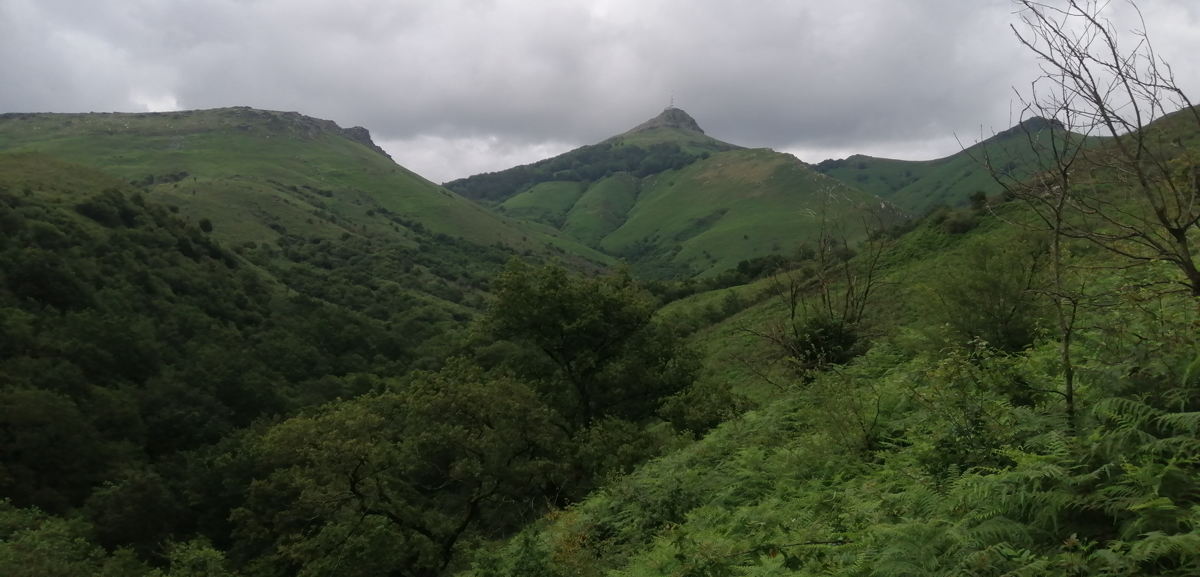
An early morning departure from Dublin saw me landing in Lourdes airport before 11am. A rather crowded and chaotic scramble to catch a bus to town saw me arrive into the town before midday. I had lots of time to go to the nearby outdoor shop to get some gas before my bus left for Cauterets. The heat came as something of a shock with the thermometers reading up to 33 degrees. It was a reminder that I was just about as far south in France as I could get. I enjoyed the bus ride to the pretty spa town and alighted at 13.50. I immediately walked up to a shop and bought a couple of litres of water and then wasted no time in heading for the trail. Once found I climbed up out of town into the woods and, once I found a quiet corner I changed my clothes to my shorts and T-shirt. My travel clothes were already damp with sweat and these were to serve as my only change for the duration of the trek. As is usual for my I was carrying about six days food. The bag was therefore pretty heavy but this gave me the option of camping wild whenever I could. Mind you the weather forecast was quite poor. Rain and lightning storms were forecast for the next week. It was however lovely right now but I knew just how quickly things could change. After climbing up through the woods for a bit the trail entered open ground and the glory of the surrounding mountains was fully revealed. Green lush valleys, full of flowers and wildlife gave was to high rocky escarpments which rose sharply to become jagged peaks. It was true mountain heaven. The skies were mostly blue but some cloud billowed up from the peaks and I knew that they could quickly become thunderheads. However, the only thunder I could hear at the moment was from the multitude of motorbikes that were heading up to a large parking area beside a ski lift. There must have been hundreds of them there and it is fair to say that they wrecked the ambiance of the area. Still a sudden arrival of a spit of rain saw them swiftly retreat back towards town and the area became once again peaceful.

The spit of rain didn't last long but it served as a warning that more was likely as the afternoon wore on. I did however have options for today. In an ideal world the weather would hold and I would be able to camp up high. There was a refuge up ahead (Refuge d'llheou at 1975 metres), where I could perhaps camp beside or stay in if the weather turned. In an ideal world, I could maybe head over Col d'llheou and reach a campsite by Lac d'Estaing. It would all depend on the weather and of course how I felt physically. On that side of things I was quite pleased. I found myself feeling quite strong and I was able to make steady progress up the valley. At the head of the valley there was a pretty waterfall and once I reached and finally passed it I entered ever wilder ground. Now I was up at over 1800 metres so I had climbed 900 metres and two hours forty five minutes had passed. It wasn't far now to the refuge. When I reached the refuge I found it to be quite busy with some children chasing about and quite a few adults milling around outside. Even though it was now after 5pm I found that I really didn't want to stay there so I decided to press on towards the Col. I reached the col at 6 pm and now that I was at 2256 metres it meant that I had climbed over 1300 metres today. It felt like a great effort for the first day and I was well pleased as I headed down towards the still unseen Lac d'Estaing.


What wasn't so pleasing however, was the first rumbles of thunder that could be heard and the evidence of the ever darkening skies overhead. When I was about half way along the descent the rain finally arrived. Not too heavy but the frequency of the rumbles seemed to be increasing even though they were as yet not near. When I entered the woods things seemed to take a turn for the worse. The rain became heavier and things became very gloomy indeed. I eventually reached the lake side but it seemed that the hoped for campsite didn't actually exist and was just a place for camper vans to park. Instead I turned right and headed towards the village of Estaing which was still over an hour away. About 500 metres beyond the lake I saw an open restaurant and auberge and went in. Alas it was just an eatery and didn't provide accommodation but the woman there said that she owned a gite nearby and I could stay there. Result!. She drove me the couple of kilometres to the gite and I counted my lucky stars as while in the car the storm truly broke. The sky darkened even deeper and the rain became torrential and all the while lightning forked across the sky. I was super relieved not to have to walk for an hour in that. The gite was basic but comfortable. It felt great to sit and relax and watch the spectacular light show from the comfort of a room. I enjoyed a great night of sleep. Day 1 covered nearly 19 kilometres, over 1300 metres ascent in just shy of 6 hours. Welcome back to the Pyrenees.
Sunday June 18th;
One of the things that is recommended when hiking in the Pyrenees is to start early and finish early so as to avoid the thunderstorms that prevail in the afternoons. With that in mind I set my alarm for 05.30. I got up when it went off but it was still quite dark outside. By the time I left the gite it was fully light but it was also clear that the weather had still not cleared and it was overcast and gloomy with the promise of more rain in the air.

The route continues from just outside the door and once it crosses the road and river it heads uphill over the shoulder of the mountainside. It was initially up through woodland (yet again) before it joined a rough track that rose gently enough until it reached open pastures above. The rain had returned and rumbles of thunder resounded from the peaks above. Damm, it seemed that the clearance I had hoped would arrive wouldn't materialise. I must confess to being nervous about hiking through lightning. We don't get a lot of it in Ireland and when we do, going onto the mountains in it would definitely not be the norm. Even though the skies were overcast the views were still great and the tops remained clear. The storm never really became bad and after a while I was able to relax.


The weather became better when I reached the higher open ground and more expansive views were on offer. My plan for the day was to try and get as far as the ski town of Gourette. It was all dependant on the weather and if things turned really bad I could stay in Arrens which was not far away. The rain came and went as I descended to Arrens but the threat of lightning receded so I had no reason to end my day early. Arrens itself was quiet and sleepy on this Sunday morning. Just a few people milled about and nothing seemed to be open. I wasted no time in setting off on the next step of the journey. After rising gently on ever quieter lanes the trail once again entered the woods. Before long I once again reached open pastures. These seemed to be mostly populated by horses. I was feeling okay but it's fair to say that I was far from flying along. By the time I reached Col de Saucede I was feeling the strain and I knew I had another col to get over to reach Gourette.


I stopped at the col for a rest and a bite to eat and contemplated the route ahead. I could see the road to Gourette that stayed high on the mountainside but the trail dropped into the valley below the road before rising and crossing it a couple of kilometres further on. Staying on the road would save a couple of hundred metres of climbing but I could also see that there were a couple of short tunnels and I didn't fancy meeting cars while in them. Therefore, when the time came I stuck to the trail and dropped into the valley. On the plus side, the weather was getting better and there was the odd patch of warm sunshine. When I reached the lowest point before the climb I was struggling and under no illusions as to what lay ahead. Still there was nothing for it but to plod on.


The next col, Col des Tortes was up at 1799 metres, so that meant a final climb of the day of almost 700 metres. I was slow but I did eventually reach it and I was able to enjoy stunning new vistas. I could also see Gourette not far away below me. I booked myself into a hotel for the night and set off down. Suddenly from seemingly out of the blue a shower of rain arrived and I had to don the rain gear again. It didn't last long however but I left the gear on rather than stopping again. Once down in the rather charmless town I went in search of my accommodation. To cut a long story short I couldn't find it. The location on booking.com wasn't correct and after getting increasingly frustrated and trying several phone calls I eventually had to concede defeat and I walked into another place and took a room. It was an end to the day I could have done without but it felt great to finally relax. The forecast rain and storms duly arrived at dinnertime and once again I was able to relax and enjoy the spectacle from the comfort of a room.Day 2 had been an eight hour day plus the time wasted in searching for my room. I had covered approximately 24 kilometres, climbed 1800 metres with 1500 metres descent.
Monday June 19th;
Once again there was lightning forecast for the afternoon but the morning had been promised dry. Alas as I exited the hotel at 7am the skies were far from clear but I hoped that this morning things would improve early. Today I would have to cross over the highest point of the trip, the Hourquette d'Arre, which at 2465 metres would be a proper visit to the high mountains. It would also mean an 1100 metre climb to reach the pass even though I was starting at over 1300 metres. I found the trail and set of out of the silent village. The trail climbs up through mostly open pastures on the left side of the valley above the town. Thankfully well away from any ski lifts. The river in the ever deepening ravine was thunderous and swollen from all the overnight rain. Unfortunately before I was a half hour into the day the rain returned and with it came the thunder. It wasn't a storm of fierce intensity but there was a couple of times when I jumped when the bang came right above me. Still there was nothing for it but to go on.
 |
| The weather was once again less than ideal. |
As I reached up near the 2000 metre mark things really started to take on the feel of the high mountains. Now there were extensive snow fields in the coums and the peaks that surrounded me were bastions of rock. When I reached the outflow from Lac d'Anglas I contemplated taking the boots off so as to get across dry but I decided to step on the submerged stones and it worked out quite well, just a little seepage entered the boots. An easy section followed as I passed a disused mining area before a steep climb up through rocks and some snow. Once up at 2300 metres it became a little more difficult to follow the trail as the markings were mostly hidden. I did find some markers that rose up to the right and I followed those. Up here the wind was quite strong and the continuous rain made it a less than pleasant experience. I finally crested the ridge and suddenly there was no more markers and the route down the steep far side was far from clear. It was then I noticed the cabin in the snow field several hundred metres away to the south of me and I realised that I had followed the wrong trail. I was up by Arre Sourins at 2600 metres and I needed to travel a few hundred metres along the ridge to reach Hourquette d'Arre so I could continue on the route. On the ridge, which was quite narrow, the wind was really strong and buffetting. My hands were also quite cold so instead of staying on the ridge I surveyed the ground to my right and reckoned that I could safely descend it to reach easier ground a few hundred metres lower.
 |
| Getting up into the high mountains..still 500mtrs higher to go. |
 |
| I basically went up to the skyline on the top right. |
Although the ground was steep the descent went fine and when I reached the easier ground I also saw that I had re-joined the trail. Thankfully down here the wind was absent and the rain had also stopped. After descending down to around the 1800 metre contour the trail crossed the river. I guess that this wouldn't present a problem with dryer weather but now the torrent was swollen and fast so I had to take off the boots and wade across. I was glad for the stabilising aid of my hiking poles. Once across there followed and long gentle descent to reach the plateau de Cezy. While I was mostly in the dry, all about showers of rain misted the mountains. Sometimes this can make things look dreary and grim but today I saw a misty magical landscape full of majesty and beauty. Two things in particular aided this view. First was the sight of the famous Pic Du Midi D'Ossau. This gnarled tower of rock rises to almost 2900 metres and presented a forbidding sight as it smouldered and towered beyond the nearer Pic de la Sagette. If Tolkien designed mountains then it would have to be in Mordor. The other was the stunning valley that stretched away to the southeast. The Val d'Artouste was a misty magical looking place that had a wide flat floor from which steep walls rose to rocky peaks of 2800 metres and more. It was a constant draw for the eye.

.jpg) |
| The descent was steeper than it looks here. |
 |
| Boots off time |
 |
| Val d'Artouste |
Once I reached the plateau the trail dropped steeply into the woods and eventually after a seemingly endless series of twists and turns reached at 1100 metres. If I thought that all the climbing was done for the day I was wrong. The trail twisted it's way around the hillside before you eventually reach a road a small lake and hydroelectric power station. Now the trail mostly followed the road down into the sleepy hamlet of Gabas. To say that I was tired by now was an understatement. I first reached a bed and breakfast but a sign on the door said that the reception was closed until 1600. It was now only just gone 1400 so I settled in to wait. I strolled down the road a hundred metres and alongside a closed little shop there was some sheltered seating. Another hiker was sitting there so I joined him. He was from Brittany and had good English so we chatted awhile. He too was waiting for the accommodation to open. At first I thought he was waiting for the B&B but it seemed that there was a refuge just alongside where we were which he had booked into and was just waiting for someone to come with the keys. He very helpfully rang the guy and sorted out a place for me as well. Before long we gained entry to the apartment and were shortly joined by three others. It made for a very comfortable and convivial evening. There was even a coffee maker there. Always a plus for me.Day 3 had also been an eight hour plus day. I had covered approximately 22 kilometres and climbed 1500 metres with 1700 metres descent.
Tuesday June 20th;
There had been the usual storms in the night and once again it was gloomy and overcast when I left the refuge. This time I didn't get one hundred metres before it started to rain. There was also some rumbling of thunder. I plodded on and before I had covered a kilometre things really took a turn for the worse. The first few kilometres of the route today were along the forrested road that rose as far as Lac de Bious Artigues. It's fair to say that it would be a shadowy walk anyway but now things became really dark. The rain became torrential and the sky became full of fury. It seemed that there was no let up in the thunder and every ten or fifteen seconds the world lit up. Quite simply I had never been out in its equal. When a farm truck pulled up alongside and stopped I wasted no time in. The kindly man drove me to the lake and on the way up we were treated to some spectacular bolts that struck down into the valley behind. Thankfully the worst was past by the time we arrived. I felt a bit shaken but very thankful and relieved.
Wow, what a start to the day. As I followed the trail around the lake I now decided that I would head as far as the Refuge d'Ayou and reassess the situation there. Thankfully only the odd rumble could now be heard and away to the south there was the odd patch of clear sky. My hopes of a sustained improvement in the weather were dashed by the sight of a black cloud coming in over a mountain ahead and by the time I neared Cabane de Roumassot the rain was once again pouring down. It didn't last long however and thankfully there was no accompanying lightning and once it was spent there seemed to be a more sustained improvement. That meant that I was able to discount stopping at the refuge and I set the village of Etsaut as my new destination for today. I kept on looking back at the mighty sight Pic Du Midi D'Ossau as it smoked with cloud and I couldn't help but feel sad that I was beginning to leave the high mountains behind me. I hadn't really thought about that before I came. I knew that the mountains would taper off as they neared the coast but I hadn't quite realised just how soon that would happen. Still I was sure that they would still be beautiful and would hold many surprises.
 |
| The way ahead |
 |
| Back to Pic de Midi D'Ossau |
There were quite a few people leaving the refuge as I passed by. I guess they had the good sense to wait for an improvement in the weather. The going was fairly easy as far as the Col d'Ayous, which at 2180 metres would be the highest point of the day. The valley ahead was long and gentle and I was looking forward to enjoying a leisurely descent. Once again the hillsides were full of cascading streams and now with the ever improving weather I could see the mountains stretching away to the horizon. After an initial steep drop I was soon on the trail as it kept close to the river in the valley floor. Not much further on I came across a group searching for a place to cross the river to get to my side. I then assumed that there was no bridge so I decided to cross myself at the earliest opportunity. It was a slightly awkward crossing but I managed it without getting wet (wetter). I was then a bit miffed to find a bridge over the torrent about 500 metres further down. My enjoyment of the descent was also marred by the ever increasing amount of mud on the trail. The passage of boots and livestock, combined with the rain, had at times turned the trail into a mudbath. The next few kilometres were the worst that I encountered all trip. At times it was simply a case of hoping that the muck didn't come over the boots as I waded through. Eventually I reached some forest trails and things improved. Next came the rather spectacular Gorges d'Enfer where the trail was cut into the cliffside and was called Chemin de la Mature. The trail was quite wide but it still made for an airy and spectacular passage. After this section the trail descended gradually to a road which soon entered the rather quaint village of Etsout. I found the gite and booked myself in for the night and settled down to relax and reflect on the day.
 |
| Le Chemin de la Mature |
Day 4 covered 25 kilometres (including a couple in the truck), climbed 1200 metres (including 150 in the truck), descended 1600 metres in 6 hours 45 mins.
Wednesday June 21st;
The cloud hung low on the mountains this morning but it didn't seem so bad and the stillness was only broken by birdsong. I was feeling pretty good and looking forward to what the day would bring. |As I passed up through Borce and entered the woods I was treated to misty views back across the valley. The first target for today was to reach the Col de Barrancq, which at 1600 metres was not too high. That said, I had started at just 600 metres so it meant a 1000 metre climb to start the day. I was quite hopeful that the weather would be better today so it came as a disappointment to feel the first drops of rain less than a half hour in. It wasn't the torrential stuff of yesterday morning but it was soon accompanied by thunder and lightning which came and went to varying degrees all the way to the col. Things never got as bad as the day before and maybe I was becoming more used to it but I wasn't as bothered by the storm today.

The thunder had passed but light rain persisted as the trail wound its way down to the flat valley below. There were some gnarly looking peaks showing through the mist and after a while some better skies began to appear. Once down in the valley a series of tracks and flower filled lanes contoured around a spur of the mountains until I finally reached a new valley and got my first sight of the village of Lescun where I could choose to stay or go on. The views from here were also wonderful as the valley was backed by a series of gorgeous mountains, all well over the 2000 metre mark, that offered, possibly the best vista of the trip so far. It felt like a delightful bonus and it seemed that I wasn't done with the high mountains just yet. The weather was all the while looking better and by the time I reached the pretty village I was able to relax in the little square and enjoy some coffee and lunch. It was still early. Once again I had started at about 7am and it had taken just 5 hours to reach here. With the weather looking better I was loath to finish the day now. So, during lunch I perused the app and map and surveyed my options. There was a refuge not too far along the trail, Refuge de l'Aberouat, which at over 1400 metres would add another 500 metres climbing to the day. That seemed like it would be enough.
 |
| Misty and beautiful after the col |
 |
| Fabulous new views |
 |
| Delights closer to hand as well. |
 |
| Leaving Lescun and the rain was coming again. |
Not long after setting off towards the refuge the rain returned and I briefly thought of returning to the village. I decided that I could reach the refuge whatever the weather and continued up. The trail went up through open pastures and woodland and it had some delightful pockets of flower meadows in forest clearings. The rain stopped before I reached the refuge and bright sun started to appear. It took me nearly an hour and a half to reach the quite large refuge and I was quite relieved to drop my bag outside. The relief didn't last long when I saw the sign on the door saying that the refuge was closed that day. I thought about pitching my tent nearby but I saw that there was a cabin further up the trail so I decided to head for that instead. The trail continued up through mature forest before eventually emerging to uninterrupted open ground that soared up to the impressive Pic d'Aine (2504 metres) at the back of the valley. Now blue skies and warm sun prevailed and everything looked wonderful. I'm not sure how I managed it but I walked past the hut without seeing it and instead continued to another hut further up the mountain. The hut I passed was I believe an open shelter but the one I reached was closed. I found a delightful spot for my tent just outside and I settled into my new home for the night. I was at Cabane du Cap de la Baitch at just under 1700 metres. It was now 15.15 so I was looking forward to a long evening recuperating in the sun. I did enjoy a couple of glorious hours but my optimism was ultimately misplaced. After I had taken the opportunity to wash my shorts, t-shirt and socks and enjoyed a brew and a bite to eat some cloud appeared to fill the valley below and it gradually crept up towards me. By 17.30 my paradise was lost in the mist and soon after the rain arrived and with it the storms. The rain was at times thunderous on the tent but I stayed dry and cosy. It eased around eleven and I rested if not slept well.
 |
| The cabin is nestling dead centre |
 |
| Camping heaven..for a while. |
 |
| Change coming fast |
 |
| Salamander |
Day 5 had been a biggie...25 kilometres plus...over 2000 metres ascent in 8 hours.
Thursday June 22nd;
It was dry this morning, mostly, and I managed to get all packed and breakfasted in the dry. One advantage of camping at nearly 1700 metres was that I only had less than 200 metres ascent to reach Pas d'Azuns at 1873 metres. The trail rose up through some rocky cliffs and I was delighted to get my first (and only) look at a curious Izzard. It felt like a gift, especially as this was definitely the last day in the high hills. I was delighted and in great form as I crested the pass and contoured around towards the nearby Pas de l'Osque which at 1922 metres would be the highest point of the day. The rain came and went as I progressed on the undulating rocky ground until I reached the top of a ski piste and after that the route wound its way steadily downhill until I reached the small ski village at Arret de la Pierre St Martin. There was a refuge here but I was only starting my day. The local farmers were also busy milking their substantial flocks of sheep. I was wary of the possibility of meeting one of the famous Pyrenean mountain dogs who can be extremely fierce when protecting their flock, but this time I didn't see any.
 |
| Leaving the cabin behind. |
 |
| Up by the pass |
 |
| Cloudy wet but beautiful. |
Once past the refuge the nature of the terrain changed. Gone were the rocky ramparts and gnarly ground. When I could get a look at the nature of the mountains ahead I could see the rounded grassy humpbacks stretching into the distance. After rising gently through pastures I reached a road that rose as far as Col de la Pierre At Martin at 1765 metres. Even though there was no lightning it was raining steadily most of the day and there didn't seem to be any great hope of a clearance. Near the Col there was another flock of sheep being milked and this time I could see one of the guard dogs in their midst. I climbed up the slope a ways until I could skirt the flock and re-joined the route a hundred metres beyond them. There wasn't a sound from the dog, phew. I was then less than pleased to see the dog detach itself from the flock and head towards me. My relief was great when the dog trotted on by me heading to more sheep on the slopes beyond. Once I realised that I wasn't in danger I was able to admire what a beautiful creature it was. |
| Rolling green hills on the way ahead |
A long descent along muddy tracks followed before I once again reached the forest where the trail became a little easier to navigate. The rain persisted and when I reached the gite at Ste Engrace I had had enough. Even though it was still just 12.30 I decided to stop for the day. The guardienne was a real sweetie and had a face on her like someone who was just after licking piss off a nettle. This she maintained for the duration. After initially grumbling that I had no reservation, she agreed that I could stay. After changing and settling in I returned and asked if I could have half board and again she grudgingly acquiesced. I settled in for the long haul. Now normally I dislike staying in dormitories but the presence of a French Canadian couple, an Englishman from the Isle of Wight and a delightful young woman from Lille who had perfect English made for a very pleasant afternoon and evening.. If I thought that the guardienne was less than pleasant to me, then she really took a set against the unfortunate English guy. He too asked for half board and was flatly refused. She wouldn't sell him bread and the only thing he was able to buy for dinner was a tin of pate and a tin of veal in oil. A native of the Basque country gave myself and the girl from Lille a tour of the village and told us a little of the symbols and culture of the area. It all made for an interesting and pleasant experience. I even slept very well.
Day 6 covered just 18.5 kilometres...650 metres ascent...1700 descent in just over five and a half hours.
Friday June 23rd;
Good news, at last. The weather forecast was very nice for the next few days. I had been quizzing people the evening before about how long it took to get to Saint Jean Pied de la Port and Hendaye after that. Each said that it took four days to reach Saint Jean and a further six days to reach Hendaye. As I had a total of nine days left I would need to make a push at some point if I was to reach Hendaye. Now that the forecast was good I decided to try and reach Saint Jean in three days.
I left the gite at 07.35 and set off on the next section. I had a delightful encounter almost immediately when I came face to face with a beautiful pine martin just a few hundred metres from the gite. It was my first time seeing one and I was thrilled. The trail, after initially following a river until it reached Pont d'Enfer, then rose up through the woods once again before it reached a quiet little road that wound its way through open pastures to reach a pass at 1381 metres. Now the skies were blue and it was pleasantly warm and I revelled in the day. I got some great looks at the frequent fly bys of vultures. What magnificent birds they are. The trail then dropped and joined another track that contoured high above a deep valley to the south. It was easy walking for several kilometres until the trail turned back on itself and entered the deep wooded gorge.
Once it crossed the river, there followed a long shaded section along forestry roads. I enjoyed a bite of lunch in the shade before shortly thereafter I reached a spectacular pedestrian bridge that spanned the gorge. I was a robust structure but it still had enough movement to thrill when in the middle of the 70 metre span. Add in the fact that you are over 400 feet above the raging torrent and it is indeed an exciting place. It was a delightful bonus to the day. Not long after this I reached the road and the gite and restaurant at Logibar. By now I had covered almost 28 kilometres but I was determined to push on and find somewhere to camp so that I could reach |Saint Jean in three days. It was warm and I was out of water so I went into the bar and asked if I could fill my water bottle and the guy tried to sell me bottled water rather than from the tap. I told him I would find a stream and left.
The climbing started straight away and soon I was once again rising up steeply through the woods. The gite was down at 400 metres so I knew I had at least for or five hundred metres of climbing to do before I would have any hope of finding a home for the night. Once out of the trees the trail rose up through vast swathes of bracken that covered the hillside. It was here that I got my first introduction to horseflies. I suddenly found that four or five of them buzzed around me and I immediately put my peaked cap to good use and swatted them away. One did manage to get a taste of me before meeting its demise but boy was their size a surprise. I needed no encouragement in keeping a vigilant eye out for them. Thankfully they had a quite distinctive low drone and I was able to know when the took an interest in me. I pressed on and when I was up at around the 900 metre contour the trail traversed the steep hillside and near an old ruined farm building I found a good water source. The long drink was very welcome and I filled up my water bottles and determined that I would camp at the next available opportunity. This came a mere two hundred metres further on when a grassy clearing surrounded by beech trees appeared. I wasted no time in dropping the bag and once I settled on a nice spot I soon had my home for the night up. It was a delightful camping experience. Calm, warm, not too many flies, a good water source nearby and somewhere to sit and enjoy the expansive views. I was a happy bunny.

Day 7 covered 32 kilometres...1800 metres ascent...1450 metres descent in just shy of 9 hours. It had been a good effort.
Saturday June 24th;
It was a beautiful weather morning. I took things a little more leisurely this morning and it was 07.40 before I was ready to set off. The beauty of starting up at the top of the ridge is that it makes for an easy start to the day and so it proved to be. The initial kilometre was a delight as it made its way along the ridge towards the next pass.. The previous day I had met a hiker who warned that this section of the trail was very muddy. When I reached a roadway where there was a large cattle through the trail took a turn for the worse. For the next few kilometres the trail was clearly also used by cattle and it made for some very sticky going. There was an almost constant need to be side stepping or sometimes simply trudge through muck and sometimes avoiding a slip was difficult. That said I was feeling pretty strong and I made good progress. It was great to be enjoying another great weather day. Finally I reached another road at Col Ugadze and I left the mud behind. A lovely easy traverse under the flanks of Pic des Escaliers (1472 metres) followed before a steep pull up onto its north spur and then a rising traverse to reach a broad grassy ridge just west of the summit. The views all along had been wonderful and I took my time and tried to soak them in. |
| Leaving the campsite. |
 |
| Nice morning for it..Pic d'Orhy 2017mtrs..The most westerly over 2000 metres |
 |
| Looking way way back |
Even though I had started up over 900 metres I had climbed over 700 metres by now and covered over eleven kilometres. I didn't have a target destination in mind for today. I just wanted to put in another good shift and see where I was after eight or so hours. It wasn't long before I reached Col Bagargi, which was quite busy, and next came Les Chalets d'Iraty where accommodation is provided for hikers of the GR 10. As it was just midday and the weather was so good it didn't even enter my head to stay. Instead I set off along the trail to discover what lay ahead. Not having a guide book and travelling in the "wrong" direction does have its drawbacks. It makes planning a little more difficult, and it is easy to miss that perfect camping spot or whatever but it also makes it feel a little more exciting and there is more of an adventurous feel to each day.
 |
| Looking to the west. Getting lower. |
The next few kilometres are easy and on good trails. Then you drop steeply down through the woods and, after crossing a road, you climb up the far side for a while before easier going returns again as you head towards Iraty. This is a busy junction where there is a mobile home park, a couple of rustic restaurants and a large parking area. It being a Saturday the area was quite busy. I went to the nearest restaurant to see if I could but a baguette or similar and I must have asked to take a dump in the middle of the floor instead judging by the response. I left quickly and continued along the trail. The route followed the road for a kilometre before the trail turns right and begins to climb towards the broad grassy summit of Okabe 1466 metres. As the route left the road at just 990 metres, it meant that the climb was nearly 500 metres. I confess to getting tired by the time I reached the top. I had covered over 23 kilometres and climbed over 1400 metres and I was looking forward to finding somewhere to camp before too long.  |
| I was tempted to camp near here..Col d'Irhu |
The next few kilometres provided easy walking and I reached another road at Col d'Irau. I had thought of pitching my tent near the col as there was nice cropped grass and a good water source but there was also signs warning against camping so I continued on. I met a hiker coming against me and asked him if he had spotted any good spots to camp ahead. He told me that once I had completed the next descent I would reach a road beside a river and that there were a couple of good spots there. I was a little sceptical about camping beside a road but when I finally reached the river at Bordes d'Intzarazki I found that the road was a 4by4 track so my mind was put at ease. Unfortunately the few good camping spots had already been taken so I had to press on. The track rose gradually across the hillside over the next few kilometres and I finally reached a farming area where I found a water-source and a nice spot for my tent. I was pretty tired and dehydrated and the first thing I did was get the tent up and set about cooking some tea. I had covered over 32 kilometres and climbed over 1600 metres and I needed to rest. Unfortunately after I had enjoyed my dinner and entered the tent to try and relax and get away from the copious amount of flies (of all kinds) I found that the tent was like an oven in the afternoon sun and soon I was a ball of sweat. I felt like I had no choice but to pack up again and make my way as far as the nearest gite at Kaskoleta . I stowed and packed away everything again and set off. Thankfully it was all downhill and I was pleasantly surprised to find that I was closer than I thought to the gite. After less than two kilometres I reached it. A very pleasant woman welcomed me to the excellent and quite newly renovated gite and soon I was enjoying the pleasure of a shower and a cool comfortable bed. 
Day 8 ended up being a nine and a half hour day, I'd covered 34 kilometres, climbed 1600 metres and descended 1940 metres. It had been another good effort.
Sunday June 25th;
The big effort of the previous two days meant that it was a relatively simple job to reach Saint Jean Pied de la Port today. Indeed it was a shorter day than I had intended but I decided to treat it like a rest day. It was a beautiful still bright morning and I was on the move just before 7am. The first four kilometres are all downhill along a quiet little country lane and after the exertions of the previous couple of days it was just the ticket. I was soon in the little village of Esterencuby where it looked like a lot of cyclists were getting ready for a ride. Almost 400 metres had been lost in height and next up came the only climb of the day, a mere 365 metre pull up and over the shoulder of Handiagamendi. One thing to note is the change in language and names of some mountains and places. This is the Basque country and the region has its own culture and language and identity. All the way from Saint Engrace to Hendaye there is a different look and feel to both the countryside and villages. it seems that every hamlet and village in the region is home to a sports hall-stadium where Pelota is played. I was fortunate to see a little of a game in Saint Engrace and it is a fast paced game played with a wooden paddle and ball on a an oversized handball/squash court. |
| Nice morning for it. |
 |
| Down in Esterencuby |
The climb over the shoulder of the hill was easy as it rose gently along another quiet little lane. I had another delightful little encounter with wildlife on the way up. This time it was a little group of what I would guess grouse or partridge chicks as they foraged on the road side. They chirped their way into the long grass as I passed and it made my morning. Soon I reached the high point and the wide lowlands where Saint Jean nestled, was laid out before me. An easy descent on good trail saw me reach another road before a final section through some woodland before I reached another road and this I followed all the way to the town. The trail entered the town at the top of the main tourist street near the citadel and it was immediately something of a shock to the system. Even though it was still before 11am there were lots and lots of people about and it felt like entering an alien land. Little shop after little shop plied their trinkets and baubles and lots of tourists mingled with lots of hikers, who I guess were here to do some of "The Camino". As there was a supermarket open until midday I made for that to stock up on some supplies and I then headed for the nice municipal campsite right in the heart of the town. I found a nice spot for my tent and relaxed for the remainder of the day. It was still before noon. |
| Yesterday the hike came over the high point on the right. |
 |
| Saint Jean lays ahead. |
The hot sunny afternoon gave way to an overcast sky in the evening and it actually rained quite heavily into the night.
Day 9 covered 18 kilometres...450 metres ascent...950 metres descent in less than 5 hours. Since I was finished so early it certainly felt like a rest day.
Monday June 26th;
The rain of the night had stopped before dawn but things were still quite overcast when I began the day. I now had six days left to reach Hendaye which was plenty of time. There was no need now to put in any big days to finish the hike. That said, each day wouldn't be too short either. The target for today was to reach Saint Ettienne de Baigorry and the GR went in as semi circular route and crossed over the top of Munhoa (1023 metres) which meant, as I was starting down at 160 metres, it would have a nice bit of climbing as well. It was after 8am when I set off into the now quiet town. After couple kilometres I was out in the countryside and the route continued along ever quieter lanes as it headed for the base of Munhoa. After five kilometres the road gave way to a track that twisted and turned up the mountainside. The cloud shrouded the summits and it was quite atmospheric. It felt a lot like being on the hills at home. I was pretty lucky really and the cloud rose with me and by the time I reached the top I had some teasing views to nearby mountains and valleys. |
| A pretty typical farmhouse |
 |
| Cloudy but dry |

 |
| Oilarandoi just about clearing |
An easy section follows until you reach Col d'Urdanzia and then you enter the woods and drop towards the pass at Ahartzago Lepoa at 737 metres. On the way I was treated to teasing views of the nearby summit called OiIarandoi 939 metres and when I reached the pass I decided to include it in my day. Unfortunately the cloud descended as I rose and I had no views but I was still glad to have done it. The summmit is adorned with a small chapel. I returned to the pass and after a bite to eat I followed the trail as it contoured around the flanks of the mountain. It dropped steeply in places down some broken rocky slopes until it crossed a shoulder and then dropped steeply to the pretty village of Saint Ettienne. Once down I walked the kilometre or so to reach the excellent campsite. It was just after 14.15 when I arrived, so once again I had a long evening to relax.
Day 10 was 22 kilometres in length...1150 metres ascent in 6 hours 20 minutes.
Tuesday June 27th;
Todays section was from Saint Ettienne to Bidarray. I was quite looking forward to this section as it crossed over a long series of rather spectacular looking tops on the French-Spanish border. Unfortunately the cloud of yesterday persisted and the tops were again hidden. It was once again dry and I was in good spirits as I walked back through the pretty village. There was a short climb up a quiet lane before a more sustained climb up through forest and then open ground saw me reach the shoulder of Aintziaga, the first major top of the ridge at 905 metres. It presented a steep rocky prow that didn't look easily climbable but the trail passed to the right and climbed up to a shallow col beyond the peak. A steep pull from the col ensues and after gaining 200 metres I arrived at the summit of Buztanzelhai at 1030 metres. The wispy cloud tried to clear and foggy views were on offer across to other tops and down to the valley far below. |
| The tops of yesterday |


Day 11 a mere 19 kilometres....1250 metres ascent in 6 hours 25 mins.
Wednesday June 28th;
I was on the move again this morning at 7am. The destination for today was the village of Ainhoa. Once again the weather was good, no rain was forecast and temps were to stay in the low twenties. The route today had a gentle start as it followed a quiet road as it meandered alongside the pretty Bastan river. It was just as well things were easy as I was feeling rough this morning. A combination of not eating enough and no sleep meant I was less than fine form. I guess the feeling that the trip was winding down also added to the malaise. I wasn't sure what to expect from now on. All the big mountains were well behind me and things certainly had a less wild feel. Still, each day would bring me somewhere new and I was looking forward to seeing what came next.
 |
| Lower hills but still wild and wonderful |
After five kilometres the trail suddenly left the road and began to climb steeply up the hillside. My fears that all things wild were behind me turned out to be unfounded. Soon I was climbing up through rough rocky ramparts and over four hundred metres of height are gained. Rounding a corner I came upon a large group of vultures, some of whom were feeding on a hidden carcass a mere twenty metres above the trail. Many more were perched on nearby rocks, seemingly patiently waiting their turn to feast. The sound of them hissing and screeching at each other by the feast was quite eerie. I wasn't about to climb up to see what was providing the food. It was a wonderful sight and it was great to see up close these wonderful birds. My mood was certainly improved but my physical struggles remained, but when I reached the top of this steep section I was suddenly on a expansive grassy plateau that provided easy walking all the way to Col de Mehatse. A rest and a decent bite to eat went some way to restoring me. The easy going continues for the next couple of kilometres along a quiet lane before the trail turns and traverses gently open hillside to reach another col at Lepoa. More easy going follows to reach Col de Trois Croix.
 |
|


After rounding the hill called |Errebi I could suddenly see the village of Ainhoa not far away. Before that I reached a rather spectacular if not a little macabre Calvary, where three large crosses were adorned by life size figures in various poses of agony. Beneath these a small graveyard sat and nearby a small chapel completed the scene. It was fascinating. The trail drops a further three hundred metres and suddenly I was in the village. It was a very pretty place with a wide street lined on either side with impressive, large, old and very Basque houses. It was clearly a tourist destination and was home to several hotels and restaurants and quite a few people milled about. I however was on a mission to find somewhere to stay. The tourist office was closed but I assumed that a village like this would have a gite. I asked in a nearby shop where it might be and was surprised to learn that there was none. I had a look at the hotels but they were quite/very expensive so I was pleased to see a sign for a farm campsite. It was quite close but when I arrived there was no one about. There was a phone number posted on a doorway and I I rang it. Unfortunately the man spoke no English and I struggled to understand him. Eventually I grasped that I had to go around the side of the barn and lo and behold there, alongside a large sheep barn was a small but perfectly formed, grassed and fenced place for camping. Toilets and showers were on the side. It was excellent. It was still early and I was the first to arrive but in a while a total of six others came to stay. At four pm the man I spoke to earlier arrived and he collected the fee. I also learned that they supplied dinner and breakfast as well. I also saw that there was a superb campers kitchen which was equipped with cooking and cooling equipment. It was a little treasure. 

Day 12 covered 22.5 kilometres....climbed 950 metres in a time of six hours.
Thursday June 29th;
I left a still sleeping Ainhoa at 07.30 and set off on the penultimate day of the trip. Todays stage went as far as a gite near Olhette but on route it passed through another village called Sare. Looking at the map there didn't seem to be much in the way of climbing today but I reserved judgement. The route followed a quiet lane away from the village through farmland and then alongside a wooded glen. It was a nice gentle start to the day and I was feeling much better than yesterday. As I walked alongside the woods I heard a deep growl from in the undergrowth not far below me. I stopped and looked but couldn't see anything so I continued on. About one hundred metres further on I heard the growl again, just as close to me. Again I couldn't see anything and I continued on. Just beyond this the route left the road and entered the woods. Again I heard the growl and again it was just as near as before. Clearly something was keeping an eye on me but again I couldn't see anything. I was getting a little anxious and I kept a constant eye out for whatever it was. All I knew was that I would be just as happy not to see it at all. I walked on and thankfully I didn't hear any more growling. After a little bit I was again able to relax and enjoy my surroundings. The easy going continued as the trail followed a river and later forest tracks before eventually reaching quiet lanes that led to the very pretty village of Sare.


This village was quite busy and was clearly another tourist hotspot. As I had covered over twelve kilometres I decided to take a little break and enjoyed a very nice coffee and pastry and relaxed for a little while before setting off on the next leg. Once again a quiet lane saw me leave the bustle behind and the trail then climbed up a scrubby hillside as it headed for a col under the quite shapely 900 metre peak called La Rhune. As I got nearer the col I could see a tourist train pass and head for the summit of La Rhune. I began to think about heading up myself.. It would have meant another 350 metres climbing added to the day but as there wasn't too much climbing in the day anyway it seemed like a good idea. Unfortunately near the col the summit became shrouded in cloud so I left it be and remained on the trail. The cloud persisted long after so I was ultimately glad I gave it a miss. Just beyond the col there was a large grassy area that was populated by horses but had good water sources and would mmake a great place to camp. Soon the trail dropped gently on the right hand side of a valley until I reached a road head at the oddly named Manttobiatta. I decided to give the nearby gite a miss after my experience in Bidarray and decided to head for a campsite about two and a half kilometres further on. I reached a busy road and soon reached the campsite but I was disappointed to find that it was just for mobile homes. I decided to press on for another two and a half kilometres until I reached the basic but good campsite there. Ascain had a small town feel about it but it was still very pretty. I went to the nearby shop for something for my dinner and when I saw that they had fresh baguettes I decided to buy one. I took a bite when I left the shop and my oh my it was delicious. Little more than half remained by the time I got back to the tent. It rained heavily into the night.

 |
| A great camp spot and looking towards journeys end. |
It had been an interesting outing but I could have done without the four kilometres plus on the busy road.
Day thirteen covered 28 kilometres....climbed 850 metres in just about 7 hours.
Friday June 30th;
Wow, the last day of the trip. It was with a mixture of relief and sadness that I greeted today. Relief that I had managed to get this far unscathed by storm, injury and excess fatigue, and sadness that after today I would have finished the wonderful GR 10 and that this particular journey of discovery I had begun all those years ago would be ending.
Relief also I guess that the heavy rain of the previous night had passed and it was a very nice weather morning. I retraced my steps along the road and once I reached the gite I began climbing up through the woods on the opposite side of the valley I came down yesterday. The trail runs through a mixture of open hillside and forest and is never too steep or taxing. It undulates its way around several hills until suddenly after around twelve kilometres into the day you arrive at Col d'lBardin with its large collection of shops and bars. I couldn't figure out why it existed at all until I looked it up. The road is on the border and it seems that all the shops etc are on the Spanish side of the road and since petrol, beer, goods etc are cheaper in Spain than in France, it explained why the place was so busy. A steep climb out of the bustle follows and soon, thankfully, the place is left behind. and the next few kilometres were the nicest of the day. To the right the Atlantic ocean and several towns on its shores lay and to the left the very pretty wooded hills of the fledgling Spanish Pyrenees were a soothing sight. |
| All the shops on the Spanish side of the road at Col d'lBardin |
 |
| La Rhune in the clear this morning |
When I arrived at what looked like the final wild place of the hike, I stopped and enjoyed a bite of lunch. The Spanish town of Irun lay across the valley below and I was surprised by how big it was. It even has an international airport as I saw a jet take off while eating. Hendaye was still hidden by the hills ahead. After a short descent I reached civilization at Biriatou. On the map it seemed so close to the end but it was another seven kilometres before I finally reached the train station. Now I know that the official end of the route is on the beach but to me that seemed arbitrary, and as I needed to catch a train back to Lourdes, the station seemed like the logical end for me. Perhaps more importantly, me feet were very tired and the relief when I finally removed the boots while I waited for my train was great indeed. I had over one and a half hours to wait for my train but it felt great to sit and relax for a while. The coffee available from the little shop in the station was surprisingly good and I indulged in several. The return to Lourdes went seamlessly and I was in my hotel near the train station by eighteen thirty. Another journey was over. |
| The Spanish mountains looking wild and wonderful |
 |
| Looking at Irun |
Day 14 Even though there were no big hills today I covered almost 27 kilometres....just shy of 1000 metres ascent in just less than seven hours.
THOUGHTS
So after travelling 336 kilometres and climbing 17500 metres over the fourteen days, how did I rate the trip. Firstly I was, and still am, very thankful to be able to do such a hike without any real problems. Of course there was fatigue, and with the storms, even some fear, but overall it was a really positive experience. Before I went I hadn't really thought about leaving the high mountains so early in the trip and I guess this came as a little disappointment. That said, day five, to and beyond Lescun, was a real delight. It was for me the highlight of the trip. I had feared that as the mountains got lower that my enjoyment would lessen, and to a small extent this was true, but there were truly enjoyable days after that. The camp above the village of Laruns, the traverse of the ridge towards Bidarray and the many wonderful sightings of vultures and other wildlife was also wonderful. The weather could have been better I guess but after day five I was spared any more storms. After that it was really quite good. If I was to begin the entire odyssey again I think I would start the traverse in Hendaye, as you would gradually be reaching wilder and wilder territory. It is also fair to say that the wildness on the eastern side of the range lasts for much closer to the sea. Now that I have done the GR 10, I find myself thinking about the Spanish GR 11 or even the HRP for possible adventures in the future. I'm sure I will come up with something.


.jpg)
