I'm back home again after a very enjoyable excursion in the Swiss Alps. I am still struggling with the dilemma of whether to hike or climb on these trips and even though I had someone sorted if I wanted to climb I opted instead for a hiking trip. I was anxious to see somewhere new this time and after a bit of research I decided to hike along the Via Alpina (Green Trail) from West to East and see how far I would get in the 12 days I had available. Going West to East would also allow me to get a decent walk in on day one and also allow me to use the excellent Swiss transport network to return to Geneva on my final evening.
Day 1...Friday June 15th;
If I was to get the maximum out of the trip I needed all the transport links to run as smoothly as possible, so it wasn't the best start when my flight was 20 minutes late leaving Dublin. I had to buy gas en route to my starting point near Montreux and I hoped to be starting my hike at or before 3pm so I could get 4 hours or so done before dinner. Not for the first time I marvelled at the super efficient and frequent train service which allowed me to reach Lausanne, disembark and buy gas at a store practically attached to the station, re-enter and hop onto a train that was literally about to leave for Montreux. This train duly arrived and I caught a delightful cog train that took me to my preferred starting point of Haute de Caux and all by 3pm on the nose. I was delighted and basked a while in my new and exotic surroundings before getting myself sorted and beginning my climbing.
The reason I decided to start from this place was number one, I would be avoiding the urban areas that stretched upwards from the lake and of course I was now at over 1100mtrs instead of at just 400 down by the lakeside. My first objective was to reach the summit of Rochers de Naye (2041mtrs) which had a couple of accommodation options and then if time permitted I planned to continue to Col de Chaude where I hoped to find a spot to pitch my tent. It was a warm hazy afternoon with the views somewhat misted out but it was still gorgeous and almost immediately I was enchanted by the dazzling display of colour in the alpine meadows I was walking by. It felt great to be setting out on another little adventure.
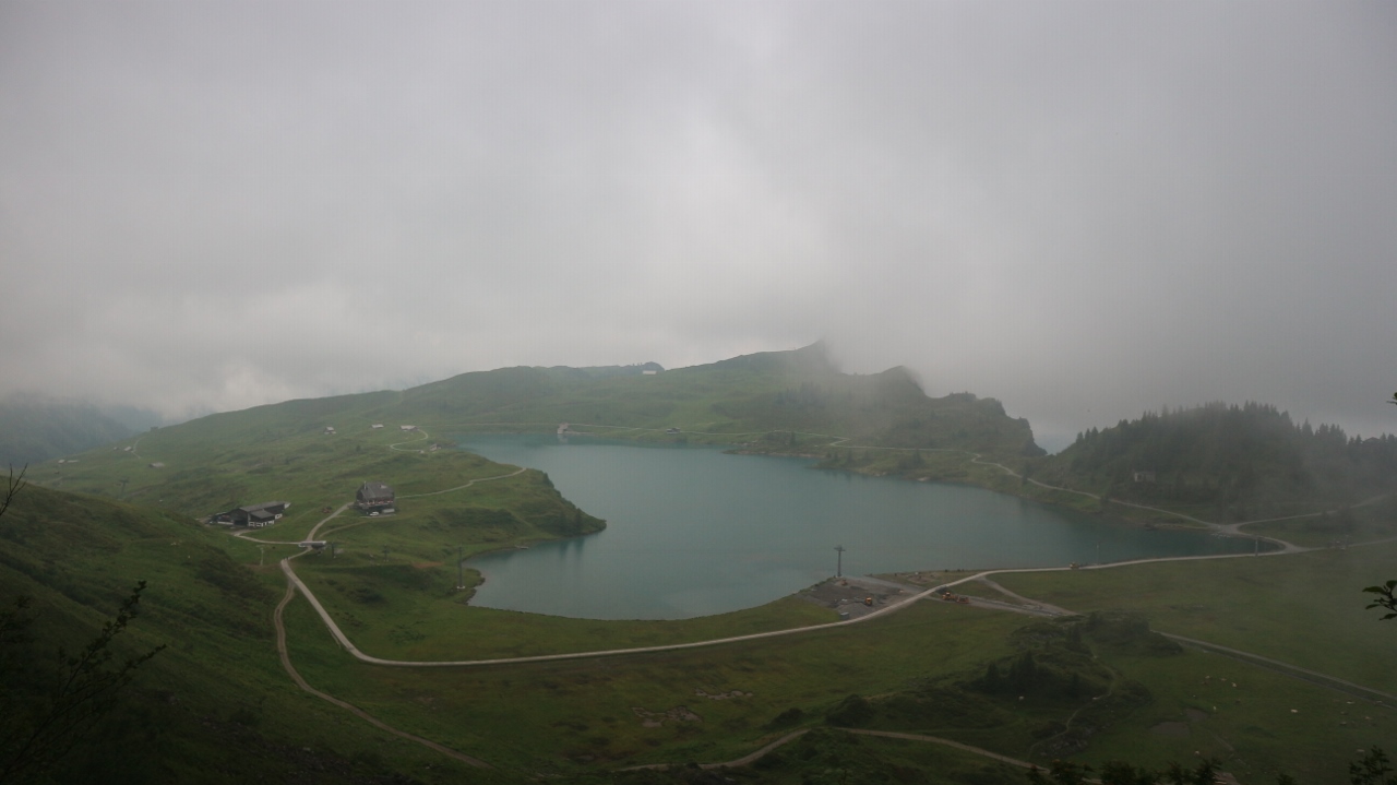
 |
| A misty but lovely Lake Geneva |
 |
| First views of the summit of Rochers de Naye |
 |
| Col de Chaude is on the right of the picture |
The trail follows a forestry road and contours gently up and around the shoulder of the mountain. At Creux a la Cierge the road ends and at this fine viewpoint there is a nice timber "refuge" where you can relax or hide from bad weather and where toilets and running water are also supplied. If a person was starting very late it might make a possible bivy spot for the night. Anyway from here I followed a steeper trail up to the narrow crest of the mountain where the summit came into view. The views widened out so I took a moment to enjoy them before I set off up the zig zag path that led to the busy saddle below the summit. The cog train I used earlier actually goes all the way to this saddle and a restaurant/hotel and an assortment of permanent camping pods give more accommodation options. There were quite a few people milling about when I arrived but I turned left and climbed the 70 or so metres to the 2040 metre summit where I enjoyed a nice rest. It was still before 17.30 so I had made decent time and I was now confident of reaching Col de Chaude on my first day. Back down to the saddle and I set off along the narrow trail. There were some patches of snow on the steep slope and in the effort of avoiding one I slipped on the newly exposed damp grassy patches and took a short slide to the trail below and I confess it knocked my confidence a bit as well as giving the knuckles on my left hand a fair old bang. Not the best of beginnings but after this it was a simple mostly downhill jaunt to reach the col which it at 1619 metres. I was now enjoying complete solitude again and as I neared the col I kept my eyes open for a possible spot for my tent and where I could find some water. Disappointingly there was neither flat ground or a water supply nearby so I ventured down along the road towards Chaude. Where the road curves around to the left there looked to be a likely spot in the glen on the right and I went down to investigate. Some good flat areas were to be found and with some big snow patches nearby I looked to be all set. After taking a walk over to inspect the snow it was a bummer to see how dirty it was so I decided to venture on further in search of a home. This was obviously cattle country and the slopes all around rang with the cacophonous clamour. I passed by a large dairy and after another couple of kilometres I reached an old barn at La Vuichoude d-en Haut which was deserted of animals ( and people), had a lovely level grassy area nearby and a good water supply just outside. I was sorted. It was just 19.30 so it felt as though I had had a reasonable outing and it was a pure pleasure to while away the evening and enjoy being in my new surroundings.
I had covered almost 15 kilometres and climbed nearly 1100 mtrs with 750 mtrs of descent thrown in for good measure. All in just less than 4.5 hours. I slept well.
 |
| Home for night 1 |
Day 2...Saturday June 16th;
 |
| Warm sun, wild garden and mountains...whats not to like |
I woke to a perfect alpine morning. Any clouds that had formed last evening were long gone and there wasn't a puff of breeze stirring the air. Today I planned on getting as far as Chateau d'Oex which was a place I'd been in during a 6 day hike on the Vaud Alps at the end of October 2016. It would make for a decent first full day effort and in these conditions I was looking forward to it. I was packed up and on the move by 8.15 and immediately was once again enjoying the riot of glorious colour on display as I descended through meadows to the quiet pastoral valley below. Once in the valley I was now faced with a climb up through more grassland to reach the col at Linderry at 1669 mtrs. About half way up I had my first problem as I couldn't find the continuation of the trail in the middle of a heavily animal tracked pasture. I kept returning to the last marker I had seen and then followed likely tracks that petered out before finally chancing upon the right one and resuming my journey. Once past Linderry I was treated to new vistas of sharp rocky peaks stretching ahead and the turquoise waters of Lac de l'Hongrin filled the valley below me on the right. Down a little bit before another gentle climb to Col de Sonlomont at 1503 mtrs and suddenly I had most of the climbing done for the day. It promised to be a straightforward end to the day as all that was left was to drop down to Rossiniere and then on to Chateau d'Oex. All went well until I reached a beautiful lush sunny meadow after going through some woods and there I again lost the markers. I found one near the start of the meadow and as the ground ahead dropped to the left and right I seemed to have options as to which way to go. I must have walked nearly every inch of that bloody meadow before eventually meeting a local guy on small tractor who pointed me in the right direction. Meadows can be the worst places to find your way, as when they are very lush with tall herbs and grasses the markers can be hidden and if they are heavily grazed then multiple tracks can make it a guessing game as well.
 |
| Last nights campsite on the hill opposite |
 |
| Vistas new |
 |
| Lac de l'Hongrin |
Anyway, once on the track again things went smoothly all the way to the hot and sunny valley floor. I sat in the glorious sunshine at a crossroads before the village and enjoyed a bite to eat. A guy who I had seen running with his dog a couple of hours earlier appeared along the lane and we had a brief chat. He had been going for five hours by now and was nearly finished which I thought was pretty impressive in the heat. I told him of my plans and he said he would love to do a traverse of the country some time. After lunch I set off towards Chateau but after a couple of kilometres the trail was closed (due to engineering works near the road) and I had to make a short detour into Les Moulins and follow the trail from there. I was now on familiar ground as when I did the Vaud Alps tour I had passed this way from Col des Mosses on a very wet day. No such weather problems today though and getting used to the baking sun was the only issue I had to deal with. Everywhere farmers were busy harvesting the hay and as it was lunchtime people were gathered outside their chalets enjoying each others company and some food. It was delightful to find that the people were so open and friendly and it was the norm, even in the town, for people to make eye contact, smile and say hello. After getting some supplies and money in the town I walked down to the campsite which was situated about a kilometre away down by the river. It was very busy and lots of people were going in to use the superb swimming pool on site. I was soon sorted and spent a lovely afternoon and evening of relaxation and sunbathing.
20 kilometres..850 climbing..1300 descent and just a bit with 6 hours.
 |
| Rossiniere |
 |
| Chateau d'Oex |
Day 3...Sunday June 17th;
It was a warm, dry and muggy morning and the extensive cloud cover overhead held the promise of rain. The destination for today was Gstaad via L'Evitaz which would make for a worthy effort without being too onerous. I had been through L'Evitaz before on my previous visit and that time I had gone there via Les Granges and over La Douvre pass which rose to over 2000mtrs. Today the route was all together gentler and crossed through farmland before entering Gorges du Pissot and following the Le Torneresse river as far as the sleepy little village. It was a very pleasant way to start the day and by then I had only covered 7.5 kilometres and climbed around 400 mtrs. From here the main climb of the day began. From the village the trail climbs steeply up into the woods where it turns right and rises more gently until you emerge once again from the forest into wonderful alpine pastures and easy walking leads you to Col de Jable at 1884 metres. The cloud of the morning was gradually burning off as the day progressed and while the tops were still predominantly in cloud I found myself walking in bright sunshine more often than not. I enjoyed a nice bite to eat here as I looked out at new views and set off on the last section of today's outing.

 |
| Just a couple would do for lunch..big boy |
 |
| The lovely little church in L'Evitez |
After the col there follows (after a short descent) a rising traverse of the upper meadows under the impressive rock towers of Gumfluh until you reach the Trittlisattel. This is a gnarly narrow crest that stretches a little ways east and offers spectacular views to the nearby rock towers and of course other peaks further afield. Once here I had also crossed from the French speaking part of Switzerland into the German speaking area..I hoped they had some English as I hadn't a word of German. At this juncture I should perhaps point out that instead of bringing paper maps with me (which would involve buying quite a few to cover the entire route) I paid a subscription to "SchweizMobile" which allowed me to download maps onto my little 7" tablet and I was able to use that for the duration of the trip. It is an excellent service and saved in both weight and money. The previous evening I had checked into a hostel in Saanen ( which is about two kilometres from Gstaad) and after checking the map I saw it was an easy thing to follow a separate trail that went in that direction instead. The descent went smoothly and I entered the quiet well manicured village in bright sunshine. After asking directions (thankfully they can mostly speak English) I set off for my lodgings. On the way there I noticed a sign for a campsite which I didn't know was there and on a whim I set off for there instead. It was quite close by and I soon had my home up for the night..
26 kilometres...1450 climbing...1300 descent in 7.5 hours
 |
| Approaching Col de Jable |
 |
| Another wonderful meadow |
 |
| Some Saanen locals |
 |
| Strange minds at work |
Day 4... Monday June 18th;
It was a bright warm sunny morning and I was looking forward to getting started on the next leg of the trip to Lenk. First I had to reach, then leave Gstaad. A nice walk along the river brought me into the exclusive resort. You know you aren't in a working class town when the first shop you see is a Louis Vuitton store. Nothing too gaudy or glitzy you understand. All understated and elegantly clean kind of sums up the town. That and the gates and security cameras on the villas on the hill out. It not being quite my comfort zone, I was glad to leave and enter more natural territory again. That is until, suspecting I had taken a wrong turn, I checked my map and discovered I was about 100 mtrs too high up and on the wrong trail. Luckily I didn't have to retrace my steps back into town and instead I cut down across open meadows and rejoined the correct track with minimal ado. The trail rose very gradually up through the hamlet of Thurbach before it turned south into the wilder surrounds of the valley that leads to the Trutlisbergpass at 2100 metres. Some cloud clung stubbornly to the tops but it was warm and sunny for the most part and again little or no breeze. On the way up I passed a couple who were busy making piles of stones in a high meadow. This is a fairly common practice as I guess it creates small clearings in stony ground where the grass can be more easily grazed and I guess over time real improvements can be made.

 |
| Heading for the Trutlisbergpass |
 |
| Looking back |
 |
| New vistas |
One of the things I really like about this type of trek is that at each pass you are treated to wonderful new landscapes that welcome and offer the promise of new adventures. This pass was I thought particularly beautiful as snow clad peaks and glaciers stretched from left to right with the Wildstrubel massif most dominant. Thankfully there was little of the spoiling affects of the ski industry to be seen and I really enjoyed the descent to Lenk. The village was set in a wide flat valley floor and it had a nice vibe about it. Busy but not too touristy and prosperous without being stuffy. The campsite on the edge of town was very well appointed with excellent showers and a kitchen and relaxation area. By the time I reached it the tarmac was too hot to walk on in bare feet and it only got sunnier as the afternoon progressed. The view from my tent up to the mountains was one of the best of the entire trip.
27+kilometres..1400+ up and 1360 down...7.5 hours
 |
| Old avalanche debris..powerful stuff snow |
 |
| One of some excellent wood carvings on the way down near the village |
 |
| Imposing wee hills..the Wildstrubel Massif looms large |
Day 5... Tuesday June 19th;
I enjoyed a crystal clear morning and warm sunshine as I left Lenk and headed towards Adelboden. There was no messing today as the trail climbed quite steeply right from the start up through pastures and patches of woodland. It made for a warm start to the day. About 500mtrs are gained this way before things ease off a bit and open sweeping land leads you towards the Hahneninmoospass at 1950 mtrs. You are back in skiing country again here with lifts going in all directions but the glorious mountain backdrop is ample compensation. As I headed towards the pass I could hear a curious racket ahead. When I got nearer it was revealed to be caused by a newly released group of about 20 cattle who sported the biggest bells of all I had seen on the trip. Their size made for a different sound (not altogether melodious) and their hunger for this new pasture meant the bells were getting a vigorous workout. The owners of the cattle were gathered in a family group admiring them and seemed proud of the cacophonous spectacle they made.
 |
| Morning glory |
 |
| A wee bit askew |
 |
| Leaving Lenk |
 |
| It aint half hot mum |
 |
| Big bells |
Again, wonderful new sights and mountain panoramas were revealed once the pass was reached. More 3000 metre plus peaks framed the way ahead and beckoned me on with promised adventures new, but first I had to reach the valley far below. The descent was quite nice and again went through the usual sequence of high Alpine pastures, then woodland and meadows populated by cattle (and their bells) before following the course of a cascading river, emerging into pastoral ground and then entering the town. Adelbolden was perched on the western side of the valley and I took some time to get some pastries and sat in the shade and enjoyed a bite of lunch. It seemed a very pleasant, bustling place but it was still early and I was feeling good so I decided to continue towards the next pass (the Bunderchrind 2384 metres) and hopefully find somewhere good to pitch my tent later.
 |
| Add caption |
 |
| Move along folks..nothing to see here :) |
From the town centre it was another 100 metres drop to the valley floor before the climbing started again. It was a delightful climb up through the usual mixed landscape but this time there were no ski lifts to marr the views. The gnarly rocky massif ahead was properly Alpine and for the rock jocks I guess would offer many superb days out. As I got higher I became more hopeful that I would find a suitable campsite. The preferred prerequisites being, away from cattle and homes and have a water supply. The pass was a wide notch in the rocky ridge, below which a huge bowl of scree curved around what appeared to be (from my viewpoint) a reasonably level area that was well above domestic interferences. It was a fairly long slog the reach the spot and it was a delight to find exactly what I had hoped in the area. Level grassy areas and a gushing water source meant I had found my home for the night. It was at a spot called Bunderchumi and was at 2108 metres. Once set up I had a long enjoyable evening as I watched the clouds form and fade and the light play on this wild place. Chamois were on the scree and snow slopes under the rock walls and stonefall occasionally echoed around coum. Cloud won the day by nightfall and sunset was mostly hidden. A few drops of rain sent me into my tent at dusk and a quiet night followed.
21 kilometres...1900 metres climbing...900 metres down in 7.5 hours
 |
| Heading for the pass..hoping to camp up higher |
Day 6... Wednesday June 20th;
The mist and cloud of the previous night had given way to crystal clear blue skies again. There are very few things to match emerging into a morning like this, in an environment like this and enjoying a quiet breakfast before packing up and setting off on my way again. The way to the pass was almost entirely snow free and I hoped that the far side would prove as amenable. Once again it was a thill to reach the crest. Stunning alpine peaks stretched out beyond the valley with that most famous of triumvirates, the Eiger, Monch and Jungfrau, peering over the others in the distance. This was a truly awesome landscape and what most caught my eye was the deep deep valley (Gesteretal) that cuts under the impressive Balmore and Doldenhorn. Other peaks over 3600 metres also soared nearby and it was a joy to rest and little bit and soak things up.
 |
| Now the clouds have gone the views are glorious |
 |
| Gesteretal valley..amazing |
 |
| The biggies appear |

The far side of the pass was also mostly snow free but the descent was initially quite steep and tricky as the winter snows had compressed and scoured the ground free of any vestiges of a path and the scree was hard and tightly bound. Still it was only for a little while and afterwards a good path went down via a long traverse to reach the pastoral ground below. Once down the going was straightforward all the was into the pretty village of Kandersteg. On the way there I met a guy who was similarly laden to myself. I asked him where he had come from and he told me he was doing the Via Alpina but that my next two passes were closed due to snow cover. I had feared as much but I decided the ask in the tourist office before proceeding further. The girl there said that for anyone confident on snow it would be okay but perhaps it would be better to ask in the Blumisalphutte to get better information. I decided that I would stay up there tonight and see what tomorrow would bring.
To reach the hut I had almost 1700 metres of climbing ahead of me so I wasted no time in setting off. It was warm and sunny leaving the village and initially the going is easy as you rise gradually up by the river which is fed by spectacular waterfalls. The scenery is truly breathtaking and it promised to get even better as the climb went on. The first target was to reach the alpine lake Oeschinensee at 1578 metres. This was supposed to be one of the most beautiful mountain lakes in all of the Alps and I was really looking forward to seeing it. It didn't disappoint. Despite being a very busy spot, the spectacle of the large turquoise lake sitting under cliffs, glaciers and 3600 metre plus snowy mountains was stunning. What a wonderful place to rest and while and relax It was easy to understand why the place was so popular and on a day such as this there would be few finer ways to spend time with friends or family than to picnic or barbecue the afternoon away in this stunning place.


 |
| A lovely traditional chalet in Kandersteg |
 |
| Gravity has got to win eventually |
 |
| Oeschinensee |


After a rest I headed off on the next section of the climb to the hut, still some time 1300 metres above. Around the northern side of the lake you go before the track rises up through some overhanging cliffs and then reaches alpine pastures full of noisy grazing cattle. At over 1900 metres trails diverge and the one to the hut heads due east as it crosses ever wilder terrain towards to the Hohturli pass at 2778 mtrs. The going was steady but never difficult and height is gained without too much strain. Soon the pastures give way to rockier ground before finally you enter the high Alpine basin under the pass. Some snowfields have to be crossed now but the ground isn't too steep and there was a good track in the snow. I reach the pass and after trying (unsuccessfully) to see what the obviously steep slope down the far side is like I turned and headed for the nearby hut. I entered the hut at 16.15 which meant I had been on the move for seven and a half hours. It had taken me just four to climb from Kandersteg without pushing it and I was feeling strong. The traditional style hut was warm and welcoming and also surprisingly busy. A large group of British military were on a training jolly so it promised to be a busy evening. Thankfully they weren't too laddish and I suspect they were drawn from the officer ranks. Anyway the very pleasant hut staff were adamant that this pass and the next one were unsafe and closed so I decided to return to Kandersteg in the morning. Clouds had built up steadily all afternoon and an hour of heavy rain washed the slopes after dinner. Things never cleared completely but a wonderful sunset was enjoyed before a good nights sleep.
21 kilometres today with 1300 metres descent and 2000 metres ascent 7.5 hours
 |
| Towards Grisalp |
 |
| Blumenalp |
Day 7... Thursday June 21st;
I guess nothing ever runs completely smoothly and I confess to disappointment as I left the hut at 8am on another beautiful weather morning. Disappointment on two fronts, first because I was retracing my steps but second because I felt I might have been braver and just gone over the pass anyway (it's not like I'm inexperienced on snow), especially since I had brought crampons with me. Not that the snow would have been hard but I hadn't brought any axe and I didn't fancy trying to halt a slide on a 40°+ slope with just a walking pole. Anyway the decision was made and it was easy to raise my spirits by enjoying my wonderful surroundings. I was feeling very strong and refreshed and easily reached Kandersteg in less than three hours. On the descent I saw several Alpine Salamanders who struck an aggressive pose whenever I got nearer them. Ugly little buggers but I was delighted to have seen something I'd not seen before. The girl in the hut had looked up train times from Kandersteg to Lauterbrunnen for me and with the usual Swiss effective service I was able to connect three short train trips and I alighted in a very busy, touristy village at 1pm. My first impression was wow☺ this is pretty (even by Swiss standards ) but then I saw the waterfall. The Stubbach waterfall drops almost 1000 feet to the deep cut valley and as most of this is freefall the water at times turns to mist before again hitting rock. It is understandably a big draw and it was at times comical to witness the battle between tourists and cars as the perfect pose or selfie was sought after. I stayed at the excellent Jungfrau campsite that evening which is very close the the falls. Clouds obscured the views into the evening but it was undeniably a gorgeous place to be.
11 kilometres and 1700 metres descent. 3 hours
 |
| The snow slope towards Grisalp was quite steep |
 |
| Beauty everywhere |
 |
| Spoilt view |
 |
| Unspoilt view :) |
 |
| Lauterbrunnen |
 |
| Campsite views |
 |
| Quiet corner..ver ver nice |
Day 8... Friday June 22nd;
After yesterday's short outing it felt good to return to normal business and get back on track. Grindlewald was the target for today and I was really looking forward to seeing the world famous trilogy of The Monch, Jungfrau and Eiger. Not that things were looking too hopeful on that front as the cloud of the previous evening had produced some rain overnight and while it was dry now, a layer of cloud shrouded the valley tops so views were limited. First order of business was finding the trail. I returned to the train station and found the indicators. I managed to do a short loop walk befor I ended back where I started. After much map checking, I figured out that the first arrow in the station was pointing in the wrong direction and pointed left instead of right. I eventually found the correct route and set off towards the first target of the day, Wengen, a village some 500 metres higher up the slope. The well made path rises in a series of switchbacks up through the woods and height is gained quite quickly. It never ceases to amaze and delight me when I see people of all ages out and about in the Alps and enjoying the wonderful environment. Today was no exception ( I guess it might have been the cooler morning) and I met several quite elderly people coming down against me. About three hundred metres above Lauterbrunnen I met an old man coming down quite carefully towards me whilst holding on to the adjacent railing. It was clear that his legs weren't the best but he gave me a big smile and continued on down. A couple of turns higher up I looked down at him and saw him take a tumble at a turn. Immediately I started to go down to aid him before halting and watching how he got on. I wanted to give him a chance to maintain his precious independence. It was a bit of a struggle but he righted himself and once upright he continued on down. I watched him awhile and he continued okay and I decided to let him be. I was filled by a sense of admiration for him and his indomitable spirit and sadness at the witnessing of perhaps one of his last independent outings on a route such as this. Getting old is a bitch and I was grateful for my still relative youth and strength.

 |
| Leaving Wengen |
 |
| Well impressed..my smile matched his |
 |
| Now who lives in a house like this ??? |
I was surprised to at just how busy Wengen was. It is a quite large place with plenty of hotels and all the tourist paraphernalia that comes in a tourist resort. I later discovered that it is a car free resort and is serviced by the cog railway that rises from Lauterbrunnen towards Kleine Scheidegg, the world famous pass under the Eiger from where you can take the Hyper Expensive train through the mountain to reach the Jungfraujoch. I quickly departed and left the hordes and after walking up through the outskirts of the town I was soon into more peaceful surroundings as the trail rose gently along a forest road. After a while the track split and offered two choices. After a cursory look at the map I chose the right hand one and, while I was able to get to Kleine Scheidegg all right it went there via Biglenlp which added considerably to distance and climbing. Not that that was necessarily a bad thing as the weather was picking up and the views into the Lauterbrunnen valley and later into the Biglen valley was getting better and better. The Jungfrau rose across the valley and although the cloud tried to clear, it never quite managed to but I did get glimpses of glaciers and snowy crests high up above.
 |
| Weather and views improving |
 |
| Kleine Scheidegg |

I eventually reached the very developed mountain pass where hotels and railways meet. Clouds had thickened again by now and the Eiger was hidden behind a misty veil. With nothing to see I didn't delay and set off for Grindlewald which I could see in the valley far below. This trail follows forest/piste roads down for the most part and isn't the most enjoyable of sections. That said I didn't have the majesty of the Eiger north face to distract me so perhaps if I had it would have been more fun. The cloud clung to the mountain but by now I was yet again walking in warm sunshine. By the time I reached the outskirts of the town it was hot and I was keen to get to the campsite. This was situated on the far side of course and a few extra kilometres of walking followed before I finally got settled. A quick visit to the very busy town with its underground shopping centre and I was back whiling the evening away at the campsite. The highlight of which was when what was visible of the Eiger lit up in flaming red at sunset.
27 kilometres...1600 metres ascent...1400 down...7 hours
 |
| The impressive Wetterhorn |
 |
| Eiger |
Day 9... Saturday June 23rd;
A crystal clear, blue sky morning greeted me when I emerged from the tent. I had to pause a while to gaze in wonder at the awesome piece of mountain architecture that is the Eiger. Not that that was necessarily the only attraction. Behind the nearby valley, the Fiescherhorn rose in an icy landscape to over 4000 metres but for me the star of the show was the Wetterhorn, 3704 metres, which loomed hugely to the east and from here it dominated the skyline. Today's destination was Meiringen which was in the next valley but first I had to go over the Gross Scheidegg pass which was at 1962 metres. It was warm and sunny at the start but after a while I was in the shadow of the Wetterhorn and it became quite chilly. The trail rises near, and frequently crosses the narrow road that connects the two towns. An obviously frequent bus service uses it and I liked that on the occasions they blew the hooter it was a musical four notes that sounded. The Wetterhorn dominates the ascent and its huge vertical north face is both beautiful and intimidating.


The pass was quite busy with model airplane enthusiasts doing their thing and lots of cyclists and hikers resting. After a brief stop and I was on my way again. The descent was very pleasant, with a nice mix of pastures and woodland. Whenever I was near the road it became clear that it is a popular route for cyclists. There are several discreet lifts from where a biker could start an ascent but if you began in the valley floor it would be a huge climb. Eventually you reach the Reichenbach Falls which is where Sherlock Holmes and Professor Moriarty had their final showdown. After that the trail descends steeply into the pretty town. The campsite at Balm was of course, a couple of kilometres on the far side of the town, but it was a nice cool wooded one with excellent facilities.
27 kilometres...1200 metres up and 1500 down. 7.75 hours
 |
| Always a delight to reach the pass |
 |
| Reichenbach Falls |
 |
| Excellent artwork in Meiringen |
Day 10... Sunday June 24th;
Where had the days gone. Already on day 10 and the end was getting near. With a view to getting transport back to Geneva on Tuesday evening for my return home on Wednesday morning I had settled on Altdorf as my journeys end. I now had two days to reach Engelberg so I decided that today I would go as far as Engstlenalp (1843 metres) where there was a hotel-hostel. It's boring I know but yet again it was a beautiful sunny morning. I walked into town and found the trail readily enough and soon I was climbing steadily up through the woods. Eventually I reached the village of Haslemere Ruiti at nearly 1100 metres, where, just to tempt or tease you the trail actually enters a lift station before exiting and climbing up through pastures again. It is a little bit of a bummer to climb beside or under a lift. It would feel a bit like cheating to take one but I felt the pitying looks of the occupants as they glided effortlessly upwards. Thankfully after a while our paths diverged and I was once again enjoying a quieter hike. After a long stretch of solitude I reached a busy road head at Gummenalp where I watched enchanted as a couple played the Alpine Horn to a herd of cows. It was a beautiful sound.


 |
| Excellent kiddies maze |
 |
| A wonderful sound |
I had climbed 1000 metres by now but I still had a long way to go to reach Planplatten which at 2245 metres was still 600 metres higher up. Some more stunning alpine floral meadows eventually gave way to wilder ground the higher I got. The views back towards the Wetterhorn and the other giants of the Bernese Oberland was always amazing but as the heat of the day grew so did the cloud. By the time I reached the busy summit (its where the lift ends) the clouds were more prevalent but I still had lots to see as I enjoyed my lunch. Most (but not all) of the climbing was done for today and I was really looking forward to the next section which stuck to the undulating ridge as it headed towards the lake at Tannensee. Almost all of this was above 2100 metres. After passing through the large lift station the trail skirts the cliffs of Rote Nollen before dropping a little and then climbing to Balmeregghorn. The going is easy and the views spectacular, especially across to the glaciated peaks beyond the Gadmertal valley and as I progressed the rock bastions of the Wendenstocke speared out of the Gental valley. Alas the cloud continued to build and by the time I neared my destination it was getting dull and I even felt a drop or two of rain. I arrived dry though and after a short wait at the hotel reception I was admitted to the dormitory (in a separate building ) that was my home for the night. It was very basic with no showers or hot water but I had it to myself and I was content. Light rain arrived near sunset but tomorrow promised more sunshine.
24 kilometres...2000 metres up and 700 down...8 hours
 |
| Curious rainbow? |
 |
| Looking east |
 |
| Waterfalls coming out of the mountain |
 |
| Home for the night..in the barn on the right |
Day 11... Monday June 25th;
Today was a short day so I wasn't in any hurry to set off for two reasons, first...I was enjoying the excellent breakfast provided by the hotel and second...it was chilly and cloudy with occasional patchy drizzle about. I was super optimistic when I left in my shorts and T-shirt but cold and drizzle meant my waterproofs had to be put on before long. The climb up to the Jochpass 2207 metres was an atmospheric affair as I was enveloped in the mist shortly after passing the Engstlensee lake but after the wonderful weather I had enjoyed up till now I couldn't complain. The pass had the usual lift station but all that was soon left behind as I started down towards Engelberg. There was quite a bit of snow on this side of the pass and in the mist some care had to be taken in following the trail but soon that was behind me and I descended to Truebsee, a lake which sat just below the mist at 1764 metres. Shortly before reaching the lake there had been a landslip on the path and a few precarious steps were required to get beyond to get beyond it. Truebsee didn't do anything for me as it was really over developed. Zip lines, lifts going is several directions and restaurants and lift stations were the order of the day and as an alpine lake it left much to be desired. I didn't hang about and I set off on the long descent to Engelberg without delay. This drops steeply in a continuous series of switchbacks that initially run adjacent to the lift up from the valley until it thankfully drifts away to the right and continues down through the woods before a mix of pastures and woods delivers you to the town below. From above Engleberg looks quite different from your typical alpine resort and it is dominated by a huge abbey and church. I went into the centre and enquired about accommodation but in the end I opted to stay in the excellent (but pricey) campsite at Eienwaldi about two kilometres outside the town. Once again the weather had cleared up and it was sunny and warm for the most part although cloud persisted on the mountain tops. After I was settled in the campsite I took the opportunits to return to the town and explored the abbey and the town centre. It is actually a lovely spot full of varied architecture and well worth a visit. Unlike everywhere I had stayed so far the campsite was on the side of town that tomorrows hike went so I would save myself a couple of kilometres then. Excellent wifi allowed me to watch Deadpool 2 that evening and I think the neighbours must have thought me a lunatic as I guffawed often at the excellent movie.
Just 15 kilometres...500 metres up and 1300 metres down...3.5 hours
Day 12... Tuesday June 26th;
Guess what?, it was another crystal clear, blue sky morning. A short walk from the campsite and I was on the trail that ran along the valley floor until after a few kilometres it reached the hamlet of Herrenruti, where some lifts (what else) and a cafe were accompanied by a curious construct of a temporary stand with "wild west" paraphernalia strewn about only added to the mystery. After this the trail turns and enters the deep Surenen valley which extends for 7 kilometres to Blacken where a huge triumvirate of coums end at the Surenenpass at 2291 metres. I must say that this valley was I think my favourite of the whole trip. The impressive rock bastion of Titlis that soars to the 3238 metres had me in danger of pulling a neck muscle as I constantly turned to my right to admire it. As if that wasn't enough ahead to the right the almost Dolomite like rocky peaks of Chli Spannort 3140 metres--Gross Spannort 3198 metres and Schlossberg Schloss 3133 metres were another delightful sight. On top of all that there was a wonderful couple of kilometres through a deciduous wood that was bursting with birdsong and colour. Waterfalls cascaded down at various points and when you combine everything it was a truly magical place. After leaving the wood the trail rises past some alpine farmsteads until after a stiff pull up past a waterfall the valley plateaus and widens to reach Blacken at 1773 metres with its curious tiny little chapel.


Here the landscape is wide and open but an impressive series of coums that stretched from the west to the north side make for a spectacular backstop. Blackenalp with its rocky runnels soaring into the clouds was particularly striking but alas it was being increasingly obscured but clouds. Up here the views back were even better and it was pure pleasure to sit and enjoy lunch in the sun and try and take in all that surrounded me. The climb up to the Surenenpass is pretty straightforward and as you near the pass there is a fine bivouac hut which would make an excellent place to stay. The pass was almost in the mist by the time I reached it and it was quite busy as a group of hikers relaxed. The far (northeast) side had extensive snow cover but it wasn't steep and I made easy progress for the next couple of kilometres until I reached Angistock where I was then on a ridge and so was snow free. From here I could see Lake Luscerne glistening turquoise far below and I knew I was nearing the end of my trek. The ridge was very pleasant but after a while I dropped into woodland and the descent started in earnest. Occasionally I could get views of the valley floor where the towns of Altdorf and Attinghausen merged to make it a busy looking area. Add to this the train lines and motorway and it was definitely a bustling Vale. Travelling in the direction I was the rigours of the route weren't bad but if you were coming up from Altdorf then it would be a long tough climb to gain the ridge 1300 metres above. I passed a couple of heavily laden young guys coming up against me and I didn't envy them the next 1000 metres of the climb. Eventually I left the mountain and walked the few kilometres to the train station. I wasn't over impressed with what I saw of the town but while I waited, I visited the old town and this was quite charming.
30 kilometres 1500 metres climbing and 2000 metres descent 8.5 hours
 |
| William Tell |
So another trek ended for me and I have to say I really enjoyed it. The weather was great and the scenery was amazing . The people were friendly and helpful and my total lack of language skills wasn't really a problem. Switzerland is expensive but with a little care it is very doable on a budget as well. Camping is well provided for but when the need arises, I have never had a problem with discreet wild camping. One thing that rankles a bit it the amount of skiing development and paraphernalia that is to be found in almost every valley. It can be a bit intrusive and definitely detracts from the experience. At some stage Switzerland must reach the point of overdevelopment. Still though...those views.........