
They say a lot can happen in a few years and boy are they right. Little did I imagine that when I did the first half of the GR 5 in June 2019, that a world wide pandemic would happen, and that it would take until 2022 before things returned to something approaching normal.
As someone who used to go on several trips a year, this trip would be my first in over thirty months. It's fair to say that I had gotten over the travel bug and I was finding it hard to motivate myself. Things weren't helped by contracting COVID (for the first time) just a month before departure. I was okay but the effects were still lingering as I left.
So, on the 15th of October I headed for Dublin for an afternoon flight to Geneva. My hope was to follow the GR 5 from Modane and get as close as possible to Nice in the 12 days I had available to me. I wasn't overly confident as I hadn't been very active over the previous couple of months and I had put on a bit of extra poundage. Ah well, I would give it a go. My lack of travel practice became evident when I boarded the wrong train in Geneva and wasn't able to reach my starting point of until midday October 16th. Oh dear.
Sunday October 16th;

I got off the train on a sleepy sunny Sunday lunchtime. Now that I had finally arrived I was keen to get underway. I had downloaded and subscribed to the Iphigenie app and this is what I would use for all my mapping needs. The target for today was to reach the Mont Thabor refuge, which lay some 1400 metres higher-up. I stowed everything away in my rucksack and set off. I soon found the trail and before too long I had left the town behind. Once I had climbed up above the motorway and became enveloped in the woods, it was like putting on a comfortable old jumper. I was back in a familiar world. That's not to say it was comfortable. Previous lack of training, extra weight and especially the after effects of COVID, all made it pretty tough going.


I managed to keep up a slow and steady pace and, as is usually the way, height is steadily gained. The trail is initially fairly steep but after around 300 metres of height gain, things ease back and a very enjoyable section follows until you reach the ski town of Valfréjus. Now the trail follows a track gently uphill. The weather was perfect. Sunny and calm and warm enough to hike in a tee shirt. Mind you, my earlier misgivings about my fitness were proving well founded. It was becoming clear that I was far from over the effects of COVID. My breathing was laboured and I was coughing and clearing regularly. I just hoped that things would improve as the days passed. Once I passed the imposing Fort du Lavoir I entered open mountain pastures and the more expansive scenery was a joy. The relatively easy going continued but my struggles remained. At one stage my vision became quite blurry and I was forced to stop and take a break. Ten minutes and some food and water helped, and it was okay once I set out again.


 Onward and ever upward was the only way and before too long I was wandering through wilder, less pastoral ground. Eventually the pass and the refuge came into view and I knew that I didn't have far to go. Up here at 2500 metres it was starting to feel quite chilly but I decided to press on to the refuge before stopping. Finally I reached the Col de la Valee Edroite and I turned and followed the track that headed for the nearby refuge. After a final climb I finally dropped the rucksack on the covered porch of the quite large imposing timber building. The guardian was finished for the season so accommodation was limited to the winter room. There was a few others milling about, but it transpired that they had earlier climbed Mont Thabor, and soon left. In the end there was just one other person besides myself staying. There was a plentiful supply of chopped wood in the refuge and we soon had a good fire going in the stove. This was very welcome. I hadn't been able to get gas on the journey but now I was able to cook my dinner on the hot plate. It made for a warm comfortable evening and was well worth the 12euro fee. I whiled away some time outside soaking in the views before retiring to bed.


All in all it had been a good day. Great weather, 15 kilometres and a substantial 1500 metres of climbing in four and a half hours. Welcome to the Alps.
Monday October 17th;
I didn't sleep well. In fact I didn't sleep at all. I don't know if it was the altitude or the chest infection but I tossed and turned and generally my breathing felt tight all night. That said I wasn't feeling bad this morning and I was looking forward to seeing what today would bring. It promised to be another fine weather day, and it was mostly blue skies when I exited the refuge. There was some cloud drifting over the nearby col but I didn't mind as I expected that to burn off quickly. Once moving I could certainly feel yesterday's exertions in my legs. Thankfully today wasn't going to be an overly big day and there wasn't a lot of climbing. Choices lay ahead for later today and tomorrow. For the hike to Briancon I wanted to take the GR 5 C variant, so I wanted to get to Nevache today. I was also toying with the idea of including Mont Thabor in the day. At 3178 metres it is a big old lump, and it would add over 700 metres climbing to the day. I reckoned that once I was unencumbered with the big bag, I could fit it in okay. I was thinking that I could get to the summit and back in two and a half hours. Alas, once I reached the Col, I saw the signpost pointing to the mountain suggested that the summit was four hours away. That would suggest (being optimistic) that it would entail a five hour round trip, and I just didn't have that sort of time and added up to an eleven hour day. I reluctantly turned away from it and stuck to the GR 5.

Once down at the Col, I entered the cloud, which filled the Vallee de la Edroite. Basically, I was then in the mist until I got below 2000 metres. However it was easy and gentle going. Despite the lack of views I was loving the trek. Open grassy pastures gave way to sparse spruce woodland before finally, where the trail dropped sharply to the right into a deep wooded valley I emerged under the cloud. It was a lovely sight as the spruce trees were aglow in their autumn finery. This valley was, until after the second world war, part of Italy and the signposts and names were still in Italian. Once I got down to the down to the hamlet that contained the refugios i Re Magi and Terzo Alpini the only meaningful climbing of the day lay ahead. Oh boy did my legs protest when I started climbing. The trail cuts straight up the slope across pastures until, when it enters the forest it goes on a rising traverse through the trees. I coped a little better after a bit, and before too long I reached the gentle Col des Thures at 2194 metres. I stopped for a little rest here and also took delight in the fact that finally the cloud seemed to be burning off and some sunshine appeared. By the time I was finished my rest it was a mostly blue sky day, and once again I was treated to glorious scenery.


Easy walking, gently downhill, follows, until you reach the solitary Cabane Pastoral des Thures at 2080 metres. Here the path splits. The right hand one takes a more or less direct line to the valley floor and Nevache, while the left hand one climbs two hundred metres, crosses the shoulder of l'Aguille Rouge, before dropping down towards the Col de l'Echelle. I took the left hand one and almost immediately was struggling on the uphill section. The views however were ample compensation for any fatigue I felt, and it was great to be once again enjoying a sunny day. Once over the shoulder the trail dropped through the woods towards the Col. I somehow managed to contrive to follow the GR 57 at the Col, and this led directly down towards Pamplinet. The proper route goes left at the col and turns north before going around and over the Roches de la Sueur, briefly entering Italy, and returning to Pamplinet from the northeast. It was just as well I didn't do that section as I fear it would have been brutal on me, given my ever increasing fatigue. It would have meant an extra 8 kilometres and over 500 metres extra ascent. Anyway, I arrived into the sleepy little village of Pamplinet and decided to continue as far as Nevache which was the logical starting point for tomorrows hike. It was quite warm and I rested and enjoyed a long drink from the fountain before heading along the good trail that leads gently over the next few kilometres to Roubion, a place where there was a restaurant and a shop. Needless to say all were closed and so was the nearby campsite. As there was an easy water supply and seating and benches in the field near the facilities I decided to camp there anyway. It was a huge relief to drop the bag and get the tent up. I wasted no time in getting into my sleeping bag and I crashed for a couple of hours.


It had taken me just shy of seven hours to cover the 23 kilometres with a modest 700 metres of ascent.

Tuesday October 18th;
I must confess I was somewhat nervous about today. It promised to be the biggest day so far, and involved a fair bit of climbing. I was pretty sure that I would struggle, given my unfit state. It was all a question of how much.
Where I was camping was right beside the river Le Claree. As the valley was pretty flat here there were some nice slow pools, in which some ducks had made there home. I emerged at dawn from the tent to a calm, clear, chilly morning. About nine campervans had also made the campground their home for the night. As I set about readying myself for the day, I was surprised to see a few walk past in shorts and with towels etc. I thought they had been using the showers of the campsite (which were locked up yesterday) but a few moments later I saw them gingerly immerse themselves in the river. Now that would certainly get rid of any morning sleepiness. As I had no gas to make tea or coffee, breakfast was a brief affair and I was all packed up and on the move by 8am. When confidence is low then take it slow. Well that is what I told myself.

A very easy first kilometre allowed me to enjoy walking alongside the river, until I reached a footbridge. Now the GR turns and headed once again for the woods. On these hikes this is a recurring theme. From a valley base the normal sequence is to climb up through the woods until you reach open alpine pastures, then cross over a col, before repeating the process in reverse. Today was no different. I steady climb up through the forest, saw me gain 600 metres before I emerged into lovely open ground that rose gently towards the first col of the day Porte de Cristol at 2531 metres. I won't say that I wasn't struggling once again, but overall I was pleased that I was able to make steady progress. Once up at the wild col the views opened up even further. I got my first glimpses of the glorious snow and ice capped Ecrins massif. What a treat it was to see these giants that rise to over 4000 metres. I could also see in the distant hazy valley floor, my destination for today, Briancon.


By now I had climbed almost 1000 metres, but the next section is an almost level traverse of the mountainside on a good track to reach first, Col de Granon (2404 metres), and then Col de Barteaux (2382 metres), almost five kilometres away. I enjoyed this section and it was lovely to see the Ecrins reveal themselves more and more as I progressed. The highlight of todays walk was to be a traverse of the Crete de Peyrolle. This was supposed to give an airy, exhilarating hike, along the ridge between a few 2600 metre tops before a steep descent to Briancon. I was debating whether to do this section or not, as I had the choice of bypassing it and staying on a lower path. Despite my fatigue, I found myself spurning the easier option and heading for the base of the climb. The climb itself gained 200 metres, and I was delighted to find it wasn't as bad as I feared. Soon I found myself enjoying easy walking and I reached the first top, Le Croix de la Cime at 2606 metres. The views were wonderful and I was so glad I decided to take this option. The next two and a half kilometres promised to be special. The path actually bypasses the highest top Le Grand Peyrolle at 2645 metres, but it still visits the ridge line and gives some airy views of the spectacular cliffs on the north-eastern side of the mountain. Further along, the trail sticks faithfully to the crest, and in a couple of places it requires a little care and concentration. All the while, the view across to the Ecrins was particularly spectacular.
 |
| Heading for Crete de Peyrolle |

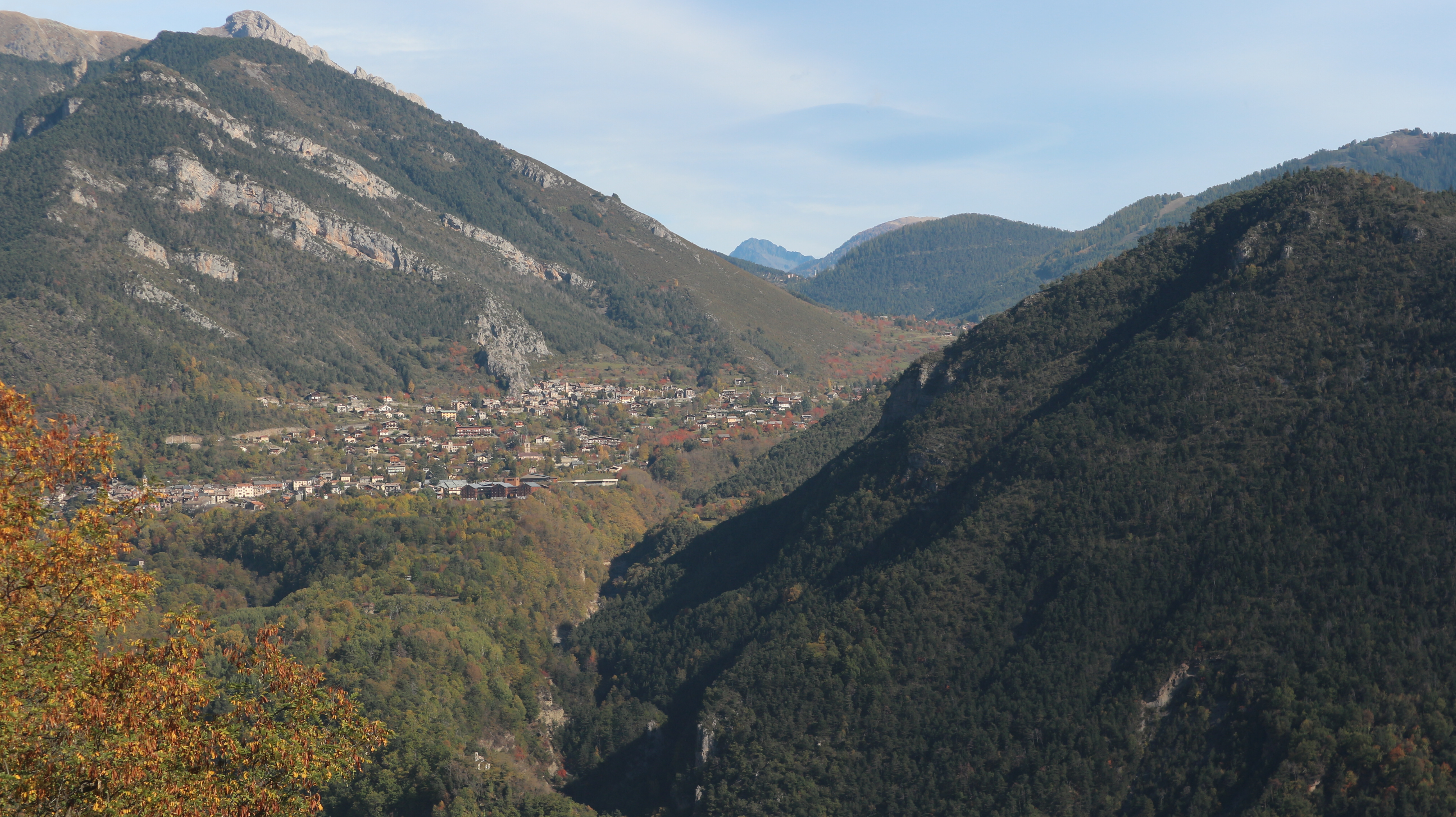
All good things come to an end, and eventually I reached the end of the crest and began the descent. Once again a little care is needed as the trail twists and winds its way down the steep mountainside until you reach the woods and an old military fort, spectacularly situated at l'Enrouye. The going is pretty straightforward from now on and the trail twists and turns until you reach a road at the Croix de Toulouse. Now the trail drops steeply through the woods, and before too long you reach an old fort, (one of several) guarding the narrows of the valley floor. Soon after, you enter the spectacular walled old town, which looked delightful. My hotel was situated about a kilometre from the old town, further down in the valley. I wasted no time in heading for it and to say I was looking forward to a long shower would be an understatement. Once I was checked in and refreshed I went about trying to get some gas so that I could cook for the rest of the trip. I was a little disappointed to discover that the nearest place I could get some was a Decathlon store which was nearly three kilometres away on the edge of town. Ah well, needs must, and I set off. On the plus side I also managed to get a couple of dehydrated dinners and breakfasts and these would prove necessary on the following days.


It had been a good day. 25 kilometres, 1500 metres ascent, 1800 metres descent in 8.5 hours.
Wednesday October 19th;
The weather was once again excellent today but bad weather was promised for the following couple of days before an improvement was due to arrive once again. I was in good spirits this morning. While I still felt tired, I was now becoming more confident that I could manage a relatively big outing and hopefully get my fitness back. Not that I planned a very big day today and it was gone 09.30 when I set off. The plan was to reach Brunissard, some twenty two kilometres away and this would mean climbing over fourteen hundred metres.

Using the Iphigeni app I had no difficulty in finding my way out of town and before long I was walking along the quiet lane above Villar St Pancrace. It was nice to pause and look back at the town and the mountains of yesterday before I once again entered the woods and climbed towards places new. After gaining a nice bit of height on the forest trail I once again reached a forestry roadway and this is followed easily for about four kilometres, until you reach the hamlet at Chalets des Ayes. Here the air was filled with the noise of cow bells. I was also up at over 1700 metres so a nice bit of height had been gained already. The trail once again entered the woods and more or less ran alongside the stream that foamed in the glen floor. It was never too steep, but it gained height steadily, until I reached a track near the junction of the treeline and open alpine pastures. By now I had cover over ten kilometres and gained over eight hundred metres so it was nice to rest a while and enjoy a cool drink in the sun.


Soon I passed the few alpages at Chalets de vers le Col and I could see the trail headed easily up to the col on the left side of the valley. I waited until I was a long way towards the col before dropping to the fledgling stream in the beginnings of a gully, so I could replenish my water. I waited until now because there were still a lot of cattle grazing up here. Before too long I reached the col and I rested a while and enjoyed wonderful new vistas. I looked back and enjoyed my last views of the Ecrin Massif. Ahead lay new horizons and wonderful mountains stretched into the distant haze. I was particularly smitten by the stunning landscape that draped the slopes of Pic de Balart, Pic de la Rousse and Pic du Cros. They weren't particularly high, or even particularly jagged, but there was something about the entire juxtaposition of rocky mountain, undulating pastures and colourful forest that had me thinking of it as somewhere from a Tolkien novel. After I was rested, I headed down into the beautiful valley below. The descent went well and before long I was over the worst and reached easier ground near some chalets. The trail now rounds the shoulder of the southern spur of Pic de Deaudouis and what was was a steep scree slope, becomes an impressive cliff face, that is a rock climbing site. A track winds down to the flat valley floor and then the GR more or less follows the road, until, after passing a campsite (closed) you reach the village of Brunissard. With no obvious place to camp nearby I continued until I reached la Chalp just a kilometre further on. A few people were chatting outside a restaurant and I tentatively asked if they knew of a good spot to pitch my tent for the evening. They were very nice, and, while they said they didn't know, they went into the restaurant and asked the owner. He, very kindly said I could pitch up in the paddock alongside his place and I readily agreed. It didn't take long to set up camp on the nice level ground and I whiled away a nice couple of hours in the afternoon sun.


About 20 kilometres and 1300 metres climbing in just six hours.
Thursday October 20th,
I exited the tent in the dawn light to another calm dry morning. Some rain was due to arrive in the afternoon and already there was quite a bit of cloud in the skies. Indeed as I was starting to get some breakfast ready at the nearby seating area, I was spattered by a sudden spit of rain that led to a hasty retreat back into my tent. Thankfully it was short lived and I was able to get packed up in the dry. Away to the south the impressive collection of snow clad peaks called Pics De La Font Sancte, which rose to over 3400 metres, looked moody and already some rain had arrived there. I made sure to put my rain gear within easy reach and I set off at 08.20.


The going is pretty easy as the trail follows a track up along the hillside after La Chalp. After about five kilometres I arrived at the Lac de Roue which would actually have made an ideal camping spot the previous evening. Lots of picnic tables, a good water source and plenty of shelter make it a great place to camp. Ah well, I had enjoyed the previous evening too much for regrets. The day couldn't make up its mind whether to rain or not. Whenever it decided to start I would quickly don the waterproofs and it would stop almost immediately. I didn't complain though, it could be worse. The trail dropped through the woods and soon reached Chateau Queyras where an impressive fort sits atop a rock outcrop that guards the narrow valley. The fort originally dated back over 1000 years. It was quite spectacular. Another spectacular sight was the large articulated truck that was firmly stuck on a sharp bend in the narrow lane that led to the lower village. The main road was blocked by roadworks and the driver obviously thought that he could use this road. A decision he deeply regretted I'm guessing. How he extricated himself I will never know.

I climbed around the truck and soon reached the trail that headed for the main pass of the day, the rather curiously named, Col de Fromage, which was still about eight kilometres away. The weather was becoming wetter and the clouds started to become lower and the day became more atmospheric. The trail itself was never very steep and overall the going was easy. Once up at around 1800 metres the valley opened out and the spruce trees became sparse and the spectacular twin peaks of Roche de Clot and Point de la Selle were framed at the head of the valley. Eventually I crossed over the shoulder of Point de la Selle and a long easy traverse of the mountain follows until the col is reached. One oddity was when I passed what appeared to be a place where gypsum was mined and below this a steep white ravine dropped for several hundred metres to the right. At the col I was delighted to see some blue skies appear and an eagle soared over the nearby Crete des Chambrettes some 300 metres higher up. I made the mistake of following a trail that was signposted for Ceillac which was my destination for today. It climbed up towards the ridge but after a while I noticed the lack of red and white markers so I retraced my steps to the col and thankfully discovered that the GR took a more directly downhill route.


The descent went nicely and before too long I reached a lane at le Villard. It was an easy couple of kilometres to reach the compact village but, as I was learning to expect on this trip, most everything seemed to be closed. I had resigned myself to staying in my tent once again, so it was a pleasant surprise to see the door to the Gite open and a light on in the office. My delight was short lived however when I was informed that they were closed. They did tell me that the Refuge de Melezet was open and that it was about four kilometres further up the valley. I decided to head for it. I walked alongside the river but had to climb one hundred and fifty metres to reach the little collection of houses in which the old refuge stood. As I arrived a woman was getting into her car. She asked if I wanted the refuge, but when I said I did she informed me that since I hadn't booked she was closing for the evening so I couldn't stay. I was a bit pissed off but I had no choice but to turn around and head back down to the river. I found a spot for my tent near a ski lift and settled down for the night. The weather continued to disimprove through the evening into the night. I could have really used a long shower and comfy bed but thems the breaks.


It had been a fairly taxing day. 27 kilometres covered with over 1400 metres climbed in 8 hours.
Friday October 21st;
It had rain all night and at times it was quite heavy. I hadn't slept well at all and I spent much of the night having something of a crisis of confidence. At one stage I spent some time looking at possible ways to abandon the trip. I had visions of flooded trails, rockfall and hardship and all without the safety net of somewhere other than the tent to stay.
This morning there was no debate as to whether to put on the waterproofs from the get go. It was raining steadily and it didn't look likely to stop anytime soon. That said, I was pleased to find that the trail was not flooded and the wind was quite light. I have often been out in a lot worse. My spirits were improving. As is often the case, once I was on the move things seemed better. I had camped quite close to where the GR climbs up into the forest and begins its journey for Col Girardin, which at just a metre short of 2700 metres is one of the highest on the entire route. I actually like walking in the rain. The world becomes a little smaller and quieter and the woods adopt a mysterious hue. So it was this morning, and it was just the ticket to re establish my commitment to the trip. Starting at 1700 metres meant that it wasn't too long before I started to leave the shelter of the trees at around the 2100 metre mark. Now the nature of the outing began to change. Here the rain was being blown by a stiff wind and it began to feel like a wet day on Carrauntoohil. As I got higher things only got worse. When I reached Chappelle Ste-Anne, which stood above the azure Lac Ste Anne, I was very glad to avail of some shelter and try and warm up a bit. Here at 2400 metres the rain was turning to hail and I had to guard my face from its sting.


Despite everything, I was enjoying myself. One of my biggest fears had been that all the rain would have fallen as snow up this high, but thankfully that wasn't the case and the pass remained clear. Another joy was the snow clad rugged mountains that formed the backdrop of the hike. The Pics de la Font Sancte, which had seemed so distant just yesterday morning, now loomed large and moody above me and in a way only looked better in these conditions. The path twisted it way up a scree slope and eventually I stood in the col. Not that I lingered, as the weather was foul. The path zig zags steeply down the slope on the other side but before too long a flat grassy area is reached. Thankfully the wind seemed less strong on this side and the rain started to ease as well. The trail splits at around 2350 metres. One branch goes directly down to Maljasset while the one I wanted traverses airely above a cliff before it begins to descend towards Le Barge. The long deep valley made a spectacular sight, backed as it was by jagged 3000 metre peaks on the other side.


I had decided to try and get as far as Fouillouse today so I still had a long way to go. Once I was down in the valley the trail spent the next seven or more kilometres in either sheltered woodlands or for short periods on the quiet road. I stopped about half way along the valley for a bite to eat and I found myself standing and shivering while I ate. Once I had put some fuel in me things got better. When I passed a little place called St Antoine I could see the river pass through a deep cleft in the rock with what appeared to be a bridge crossing it. It looked spectacular. Another thing that looked equally spectacular was the stunning autumnal colour on display in the valley beyond. Eventually I passed the cleft and I was delighted to find that the way to Fouillouse actually went over the bridge. Wowzer, what a spectacular place to stand. Looking over the walls of the bridge at the 300 ft drop to the torrent below certainly got the heart racing. It was a lovely bonus. Shortly after this the trail leaves the road and climbs up through the woods again. All in all you climb over 300 metres before a gradual descent arrives and you reach Fouillouse. I had hoped that the gite in this curious village would be open but alas it would be the tent again tonight. Mind you things weren't all bad. The weather was actually showing signs of improvement and by the time I reached a spot where I could camp about 500 metres beyond the village it was dry. Fouillouse itself was an odd collection of chalets and farm buildings with mostly tin roofs and a mucky dirt track serving as the street through it. That said it was in a beautiful setting.

23 kilometres covered today with once again 1400 metres of climbing in 7 hours 40 minutes.
Saturday October 22nd;
There had been some rain overnight but it had dried up and it was quite a pleasant morning when I emerged from my tent. I enjoyed a nice breakfast and it was good to be able to pack up in dry weather. I was hopeful that the rain was behind me. Today the plan was to cross, first the Col du Vallonet at 2524 metres, before next crossing Col de Mallemort at 2558 metres, and then descending to Larche. After that I would play it by ear.
The trail rose quite gradually along a track and was never steep. That said, I was struggling a lot this morning, and I felt like I had regressed a few days in fitness. I had thought that I was over the lingering effects of Covid but my chest and breathing was tight, even on easy gradients, I found the going tough. Before long I reached Fort de Plat Lombarde. This was a quite large buried fortification with only the gunwales showing above ground. Here the trail splits, with one heading up to the Refuge du Chambeyron and the GR 5 continueing towards the col, which could be seen a few kilometres further on. There was still a fair bit of cloud about but the views were still wonderful and despite my fatigue I was enjoying the day. Once I reached the col the trail descends gently as it heads towards the valley that rises to Col de Mallemort. Around two hundred metres are lost until you reach an old military road that rises towards the col. The cloud started to clear and by the time I was up at the col the impressive rocky ramparts of the surrounding tops could be seen. An impressive ruined barracks stood just below the col and there were two further fortifications on the tops of the peaks either side. Further evidence of the turbulent past of the area.


The views were excellent from the col and I rested a while and enjoyed a bite to eat. It was a little disappointing to see that across the valley some rain was once again falling. The descent takes a fairly direct line towards the little village of Larche. It was quite straightforward and before too long I reached it. As I said it is a small place and once again everything was closed. I didn't linger and I set off along the lane that stretched for five kilometres to a parking area. Just two hundred metres of height is gained on this stretch so the going is easy. The rain had arrived once again but I was hopeful that it would clear. When I reached the end of the lane at a large parking area, I had reached Val Fourane and the Mercantour National Park. Alongside the empty carpark, there was a timber building which was open. I reckoned that it would make a good spot to stay for the night, so I dropped my bag and relaxed. The rain had stopped however and the valley ahead looked tempting, so I decided to continue for another bit. After a further kilometre up the valley I spied an ideal place to pitch the tent that was too good to pass, so I had found my home for the night. I whiled away the remaining daylight in quiet relaxation and pondered what the coming days would bring. My crisis of confidence was over and I was really looking forward to discovering what lay ahead.


It hadn't been an overly taxing day..20 kilometres covered and 1100 metres ascent in 7 hours.
Sunday October 23rd;
Thankfully the fatigue of yesterday was absent this morning and so was the rain. I was really looking forward to entering once again the Mercantour Park. It is renowned as one of the wildest, most unspoiled areas of the western alps. One thing that I was becoming concerned about was the fact that this would be my fifth day wild camping after Briancon and my phone and battery pack, not to mention food, needed to be topped up. I was using wipes to refresh myself but it is fair to say that a shower would have been welcome. The next town of any consequence I would reach was Saint Etienne de Tinee which was still a fair way off. I kind of hoped that I might reach it today but it would be a big effort and I would just see what developed. The view to the north from the tent looked at the Tete de Moise and other peaks that formed the border between France and Italy. The sky looked menacing and some rain was misting the peaks. To the south, my direction of travel, the sky looked much clearer and I hoped that blue skies would win the day. The Pas de la Cavale at 2671 metres could be seen in the distance and it was flanked by wild and rocky peaks. It all looked very inviting.

 |
| What a lovely morning. |
Once packed up and on the move, I followed the track until it became a trail and climbed towards Lac de Lauzanier at 2284 metres, which wasn't too much of a climb, as I had camped at 1950 metres. I was delighted by the wildness of the scenery when I got up to the lake, and things only got better as I headed for the col. I guess it is no coincidence that the wildness of the place was matched by the wildlife. This morning I saw deer, male Ibex butted heads and eagles soared. I was also feeling fairly strong and I hoped the finally I was getting over the chest infection. What a delightful view greeted me at the wild pass. The fledgling Tinee Valley began below me and it basically ran all the way to the Mediterranean. Not that I could see the sea from here, it was still a long way away, but there was much to delight the eye. The trail drops steeply through the brittle rocky headwall, before easier ground is reached. A rather chaotic melange of rock strata sweeps away to the west, with the most spectacular being the huge band of black shale called Les Roubines Negres. Lower down the trail descends easily across grass slopes before crossing a wide rubbly, avalanche or water scoured stream bed. A refuge/bothy is passed, before another 200 metre climb, sees you reach the altogether tamer Col des Fourches at 2261 metres. Here there are some more gunwales guarding the valley below.


 |
| North from Pas de la Cavale |
 |
| Looking South |
As I neared the col the air was filled with the sound of high powered cars screaming up a roadway. After leaving the col I soon reached the road that rises to the Col de la Bonette which is the highest road pass in western Europe. Alas I missed seeing the type of cars that had caused the earlier racket and instead I saw a few, lets just say less skilled and less powerful stragglers as they spluttered and slid up the slopes. A short walk on the road follows before you reach the nearby Camp de Fourches. Now the trail dropped through the grassy slopes and headed for the hamlet of Bousieyas at 1900 metres. The weather was turning out very nice and I was really enjoying my day. I enjoyed a long cool drink and bite to eat at the deserted hamlet, before beginning the next climb to the Col de la Colombiere at 2237 metres. The trail followed a vehicle track, so it was never steep but it did add another 400 metres ascent to the day. Once up here I rested and since I had a good phone signal I went online and searched for somewhere to stay in Saint Etienne. Miraculously there was one property available, a studio apartment, and I immediately booked myself in for that night. Now all I had to do was get there.


The trail crossed some steep slopes as it headed towards Vallon de St Dalmas. Here I noticed a marked difference in the flora on this side of the col. Now, things had a much more arid, scrubby feel and look. The Mediterranean clearly had a big influence here. The trail dropped and contoured around some deep ravines, before eventually, the village of St Dalmas le Selvage came into view not too far away. The compact cluster of houses, arranged in a somewhat chaotic jumble of narrow alleys was a shabby delight. Ordinarily I would have delighted in spending a little time wandering and exploring, but I was struck by shower fever. I wanted to reach Saint Etienne as soon a possible. It was also a surprise to fine that the Gite in the village was actually open. Once I was down below the pretty painted church, I began the final climb of the day and headed for Col d'Anelle which at 1731 was another 200 metres higher up. Before too long I reached the pass, and after a traverse through the woods, I finally began the steep descent to Saint Etienne, which nestled in the valley below. The surrounding woods were a riot of colour, and now that I knew I would reach the town in reasonable time, I relaxed and enjoyed the descent. I was also very pleased with how my body had held up to the rigours of a long day. It was an enormous relief to finally reach the town and find my accommodation. Once settled in, I wasted no time in enjoying a long hot soothing shower. Bliss. It being a Sunday evening I wasn't hopeful of finding anywhere open for a bite to eat, so it was a particular delight to find a pizza place open. I enjoyed a delicious pizza and some wine for dinner. A great end to a great day.


31 kilometres with 1600 metres ascent, 2100 metres descent, in 9 hours 30 minutes. I slept well.
Monday October 24th;
It had rained yesterday evening but the forecast for the reminder of the trip was great. Considering that yesterday had been a pretty big day I was pleased with how good I felt this morning. Having spent some time studying the reminder of the route, it was clear to me that a big effort would be required to get anywhere near Nice in the four days I had left. Well I suppose I could have done a short day on Friday morning, as my flight wasn't until 15.30, but I didn't really want to be under too much pressure on that day. I would just see how things developed.
I had been looking forward to getting some nice fresh baguettes in the bakery before setting off, but I was to be disappointed, as it was closed on Mondays. The little shop didn't stock any bread, so I had to make do with brioche and some biscuits. The trail followed a quiet road out of the town until after a couple of kilometres it started to climb. As I left the town the hillside opposite echoed with the bellows of stags. A small flock of sheep in a roadside paddock were all fixated by the sound, and silently stared in that direction. Soon the main road is reach and after a couple of hundred metres walk along it, you climb up through the forest until you reach the ski town of Auron. This sits at 1650 metres, so already nearly 500 metres of climbing was done. Auron is quite large and to my eyes quite charmless. It consists of a jumble of large, no doubt expensive, chalets and apartments with the usual collection of restaurants and ski stores. Everything was closed now, but during the season, I guess there would be a buzz. Anyway, I was glad to leave it behind and once I was across the valley with it's car parks and ski runs, I once again entered the woods, and the trail headed for Col de Blainon at 2008 metres. Once I reached the Col I had done 1000 metres of climbing and the day was still young.
 |
| Leaving St Etienne..those colours |


Next comes the pleasant descent to the little hamlet of Roya. The trail crosses open pastures and I was struck by the unusual proliferation of timber and stone barns that were in varying states of disrepair and ruin. Very few were still being used and I found the area looked little eerie. Roya itself had something of an old timeless feel. It was an interesting section of the hike. I stopped for some lunch by the river in the valley floor, before I began the long climb to Col de Crousette at 2480 metres. After an initial steep section the trail rises gently through the Vallon de la Mairis. Once through a narrows where the trail is menaced by a crumbling overhanging cliff, things open up. You cross the river and rise up through open, ever wilder ground. At the end of Vallon de Sallevieille the climbs steeply up through some rocky ground before reaching another surprisingly large valley at Les Laces. It was yet another demonstration of the scale of these mountains. A further two kilometres and two hundred metres of climbing saw me reach the wild col. There was a stiff breeze up here and it was decidedly chilly, especially since I was still just in my tee shirt. I was looking forward to losing height and reaching a more sheltered position. I was surprised to see the trail continued to climb to the left until it reached the crest of Le Petite Mounier. All in all a further one hundred metres is climbed before the trail heads for Mont Demant. I had to give in, and stop and don some clothes, but once that was done I was toasty warm and able to enjoy the next absolutely delightful section as I headed for Col des Moulines.


I had been on the move for a long time now and finding somewhere to camp for the night was the next priority. There was no chance before the col, as the trail went along the broad crest of Mont Démant all the way to the col. After the col the route dropped steeply into the wide valley under Mont Mounier, and even from a distance, I could see that camping opportunities would be found there. Once I reached the stream in the floor of the valley, a likely spot was available just nearby. I dropped my bag and spent some time scouting around for the best spot. I spotted another place a couple of hundred metres further on, and once I gave had a look, it was clearly an even better spot, so I opted for there. It is well worth spending a little time deciding on the best spot for the tent as small differences can make for a much more comfortable night. I whiled away the remaining daylight in the calm pleasant evening in solitude and quiet. It had been a good day.


27 kilometres covered, 2200 metres of ascent, 1600 metres descent, in 9 hours. A long rest was most welcome.
Tuesday October 25th;
Today I hoped to reach the village of Saint Dalmas de Valdeblore. It would be another pretty big day so I was packed up and on the move by 8am. It was a lovely morning and the weather promised to be great all the way to Nice. A nice easy start was just the ticket and the trail contoured around the hillside before entering a ravine above the hamlet of Vignols. The ravine was quite spectacular as it was overlooked by a a spectacular hillside covered in outcrops and spires of crumbly rock. An added bonus was the sudden appearance of two eagles between two nearby spires who were being chased off by an angry crow. Lovely. Next up comes the near 200 metre climb up and through the Portes des Lognon. Once through the gap I entered a beautiful, wide, alpine meadowed valley, and delightful easy walking ensued until you reach the vacherie and refuge nearly three kilometres further on. Now the nature of the outing changed as the trail dropped into the forest and dropped steeply until you reach a forest road. This is followed gently downhill most of the way to the delightful hilltop village of Roure.


One thing that happened on the steep section not long after passing the Refuge de Lognon, was when I felt an odd sensation in the sole of my right boot. I had literally been thinking just how excellent they were, and how I hadn't had a blister or even a sore spot for the entire hike. Anyway, it felt like something had gotten stuck in the sole but after a few steps it seemed to literally click back into place. I began to get a horrible suspicion that the sole was after splitting and I wondered if they would last the day, never mind the rest of the trek. I continued on without checking, as I reckoned that there wasn't much I could do about it anyway. I was glad to discover that things weren't getting any worse. There was also a definite sensation of leaving the high mountains behind as I headed inexorably towards the coast.
 |
| Roure |
Roure sits on a rocky outcrop at an elevation of over 1000 metres some 500 metres above the Tinee Valley floor. It was sunny and quite warm and promised to get warmer still as I progressed. Down down into the deep valley until I reached the village of St Sauveur sur Tinee. It didn't take long to pass through it and another 500 metre climb awaited as I headed for the still hidden village of Rimplas. The climb was mostly on a forest road and wasn't too taxing. Some delightful views were offered back to Roure and Mont Munier, which now looked a long way back, and the deep forested valleys offered delightful interest nearby. At the 860 metre contour I could finally see Rimplas ahead at the end of a long traverse of the Ravine de l'Esclose. I had now covered twenty three kilometres but there was still a fair way to go so I didn't delay before leaving the undoubtedly pretty village. After Rimplas, height is gradually lost and I could see the twin villages of La Bolline and La Roche some four kilometres ahead. I had feared that the trail would drop right down to the valley floor on the right but thankfully it only dropped a couple of hundred metres, which left a 250 metre drag to reach them. The trail actually skirts each village and passes through lanes that were home to lots of modern homes. The wild remote feel to the villages was gradually being lost the nearer I got to the coast.
 |
| La Bolline |
The climb up through the woods to Bolline went okay and thereafter the trail follows a series of lanes that skirted most of the houses. I pushed on and before long I was out in the open countryside and heading for St Dalmas and todays end. It wasn't as long as I feared to reach the village and there wasn't much of a climb either. That said I was mightily relieved to reach the shop in the village and get some bread fresh from the oven. It was glorious later on. I walked the extra kilometre to the quite busy campsite and before long I was settled for the evening.


I had been another substantial day with 32 kilometres covered, 1500 metres ascent, 1800 metres descent, in almost nine hours.
Wednesday October 26th;
It was another lovely weather morning as I left a sleepy St Dalmas. I went down to the shop to stock up on more bread and another couple of bits but was disappointed to find it was closed until 12.00. They do like their time off in this neck of the world. I was a bit peeved but I still had enough for dinner and breakfast tomorrow so all was okay. Still, that fresh baked baguette would have been nice. I soon found the trail out of the village and began the climb towards Col des Deux Claire's which at over 1900 metres gave a 700 metre climb to start the day. It was never steep and I guess it is fair to say that I had gained some fitness over the course of the trek so it is no surprise that I felt good. Once up at the Col I had my first encounter with one of the guard dogs that protect flocks of sheep or goats from predators. It didn't come very close to me but let me know it was watching me and followed me along the trail until I was well away from its charges.
 |
| Once again up at around 2000 metres. The flock of sheep at the col |
The trail stayed just below the mountain crest and instead traversed the grassy slopes from col to col. It continued in this way for five or six kilometres, giving excellent views. Eventually near Col du Fort the trail dropped into the woods. Three hundred metres lower I reached les Granges de la Brasque where cattle grazed an old army barracks and a ruined church clustered by a road. The trail followed the road horizontally for another few kilometres before at Col d'Andrion it dropped through the woods again until it reached Col des Fournes at 1350 metres. It undulated its way through the forest as it headed towards the rocky limestone outcrop called le Brec d'Utelle. One thing of note was the amount of rooting that wild boar had done. Large areas either side of the trail had been ploughed up, most of it looked recently done too. I began to pay more attention to the scrubby undergrowth either side of the trail and I fully expected to see some boar. As it transpired I didn't and I was just as glad.
 |
| The Med is away there somewhere |
 |
| Mont Mounier. Hard to believe I camped under it only yesterday. Making progress |
 |
| Towards Vesubie and the 3000 metre tops of the French Italian border |

Once I reached the quite spectacular Brec they trail climbed its narrow flank before crossing to the other side where a superb well constructed track contoured through the steep rocky ramparts of the mountain. Eventually,after reaching the Col du Castle Gineste the trail enters the woods again and drops gradually towards the hilltop village of Utelle. As I entered the village I spotted a possible spot to pitch my tent but I continued into the village as there a gite there that might be open. I entered the pretty square where there was a water source and some seating and dropped the bag. The gite was in the square but it was indeed closed. I relaxed a while in the warm sunshine and chatted to the man, who had excellent English and was originally from Belgium. After a while I went to look at the rather large church for such a small place and when I went to a higher area just beyond it I was delighted to discover a small grassy viewing platform that wasn't overlooked by anything. I had found my home for the night.
 |
| A great spot for the tent |


It had been another good day. 28 kilometres covered, 1200 metres ascent, 1700 metres descent, in 8 hours.
Thursday October 27th;
Day twelve had arrived and journeys end was near. Well not really that near as it was well over thirty kilometres to Nice. I had a decision to make later, whether to stop at the final village before Nice, Aspremont, or try and reach Nice itself. It was another glorious morning and I was feeling good as I left the still sleeping village. Utelle sits at around 800 metres and overlooks the Gorges de Vesubie. The route descends and crosses the river in the valley floor way down at 190 metres so a lot of height is lost. The trail leaves the village and contours the Vallon de l'Aclap, descending gently all the while. A delightful little chapel and refuge is reached called called Chapelle St Antoine. Inside there is a little bench, a table and chair, a wood burner and some religious iconography and a little altar. It felt like a magical little spot. Further on the trail contours under the rocky ramparts of Crete de la Pallu before it starts to descend in earnest to the valley floor. It passed through the cluster of houses at le Cros d'Utelle and soon after the busy road and the river are reached.

 |
| Leaving Utelle |

 |
| And the villages become towns |
After crossing the fine stone footbridge you climb once again towards the next village, Levens, which lay almost 400 metres higher up. After passing the Canal de Vesubie, which was built to provide Nice with a more reliable supply of water, the climb rises through the woods once again. It was really quite warm and when I reached the large village/town the sunshine made it feel like a really good summers day at home. The old village could be seen on the right but the trail skirted this along some busy modern streets before it eventually reached a large area of parkland. As I had covered fourteen kilometres and been on the move for four hours, I rested awhile and enjoyed some of the last of my supplies. Just beyond the park the urban setting was left behind and the trail once again entered the woods. It seemed that the easiest way to guage progress today would be by ticking off the villages en route. Next up was Ste Claire. After a steep drop where 100 metres was swiftly lost, I feared that I would be facing another stiff climb to reach the village. Thankfully the trail levelled out and only a one hundred metres of ascent was needed. It was very noticeable how much more developed all the hillsides now were. Before it seemed like everywhere was virgin woodland and only the occasional hamlet or village was to be found. Now the hillsides were liberally sprinkled with villas and the sound of traffic began to intrude. In truth I was glad that the hike was ending.
 |
| Aspremont |
A long walk on a quiet lane followed before I reached Colla Partida. Here the trail contoured under a rocky outcrop and then began a long contour under Mont Cima. Eventually I reached another roadway and before long I was walking down into Aspremont. I kinda debated with myself as to call it a day here or push on to Nice. It really was an easy choice. It wouldn't seem right to stop here. There was a stiff climb out of the village and before long a stoney scrubby trail was contouring under the final mountain of the trek, Mont Chauve d'Aspremont. Having reached a high point at about the 700 metre contour, a long almost level stretch followed along Crete de Graus. Suddenly the metropolis of Nice could be seen ahead. It made a fine sight in the hazey sunshine. Indeed it was so hazey that the Mediterranean could only barely be seen. In the valley floor to the right a huge flat expanse of ground was covered in industrial and residential areas. Now there was a constant buzz from the motorway that ran through it.
 |
| Nearing Nice |
Finally the increasingly busy trail dropped into the woods and very shortly thereafter I reached the paved streets of Gairaut, which basically marked the start of the urban area. Walking downhill for a long time on tarmac isn't my favourite thing, but any misgivings were overshadowed by the fact that I had reached journeys end. All in all about 300 metres was lost while descending the increasingly busy streets so it was a relief, not long after crossing over a motorway, to finally reach St Maurice on the northern side of the city centre. Now I know that the route goes all the way to the Promenade des Anglais but I was completely satisfied to end my hike here. The rather dubious delights of another three kilometres through the busy streets wasn't for me. I made my way to the tram line and after a short ride I alighted by the train station. I checked into my hotel and enjoyed the evening in comfort and quiet reflection.


 |
| Nice morning for a swim |
So the final day totalled 34 kilometres, with 1300 metres ascent, 1900 metres descent, in just nine hours.
Overall I was very pleased. A tough start had made it all sweeter to feel stronger in the latter stages and it is fair to say that by the final few days I was in as good a hiking fettle as I have ever been. It was also nice to finally complete the GR. I couldn't decide whether it was more enjoyable to do it in summer or late autumn. In the summer the days are long, the wildflowers cover the meadows, and everywhere bursts with life. Every possible type of accommodation is open and you have much more choice about how far you go, what to eat and where to stay. In the autumn, almost everything outside of the towns is closed and this definitely presents difficulties. I had to stay in my tent most nights, and during the long hours of darkness this can become a bit trying. I had to ensure I carried enough food to see me through several days. After Briancon I had enough food for six days and I needed it all. On the plus side, the trail is super quiet, almost totally empty in fact. This might not suit everyone but to me it is a big plus. Also there is the colour. I know that in the summer you have the flowers, but my oh my, the landscape in a wonder at this time of year. The spruce trees were a variety of golden yellows, depending on the light, and they set the mountainsides afire. Lower down, especially further south, deciduous shrubs and trees set the valleys alight in a cacophony of colour. But it was the reddish amber of the naked hillsides, whose every hump and hollow was laid bare in the soft light, that captured my heart. At times the landscape took on a mystical look, that seemed to be straight out of a Tolkien novel, and seemed the stuff of fairy tales. It is fair to say I was smitten.
In total I had over 300 kilometres and climbed almost 17000 metres in twelve days. There is a little life left in the old dog yet.