
Tuesday November 7th;
Connemara is always a joy to visit. The stunning mix of sea, bog, lake and mountain is ever changing and interesting and everywhere you look is a wonder to behold. It is fair to say that I was looking forward to returning. I had booked myself into the Leenane hotel for a few nights and so all I needed way some decent weather. The west of Ireland weather can be poor at any time of year but in winter it is certainly a lottery whether the outdoors can be fully enjoyed. I was therefore reasonably pleased that the forecast was for a good start to the trip and Friday was to be good as well. Two out of four is a pretty good result. I was pleased to see that things were indeed pretty good as I drove the long journey northwest. I started out quite early 06.50 and despite heavy traffic getting through Galway I found myself entering the wonderful wilds not long after 10 am. I wasn't sure what exactly I would do today (what else is new) but when I reached Maam Cross I turned right and decided that I would repeat a walk I had done once before on the westernmost section of The Maumturks. That time I walked from the high point on the road between Maum Cross and Maum and went out and back to Binn Mhór in the cloud. Today with clear tops and mostly blue skies I reckoned it would be a whole new experience.

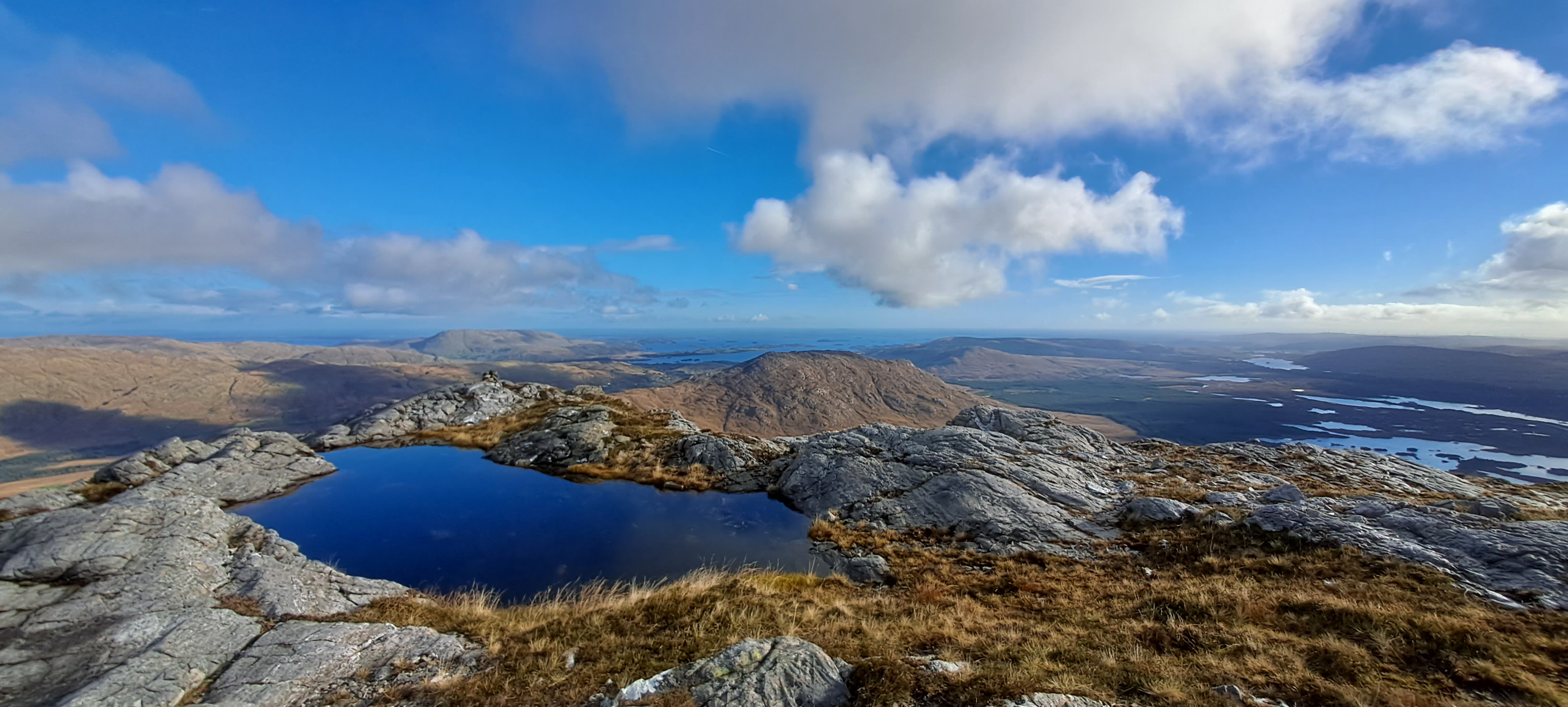

While it was sunny, I wasn't in any doubt what time of year it was as a chilly brisk breeze had me don my jacket right at the start. I left the car at 10.40 and started off across the bog towards Corcogemore, which at 610 metres meant that a 530 metre climb loomed. And loom it certainly did as before long the ground rises steeply. I wasn't too subtle in trying to find a way up. I simply avoided the rock ramparts and took as direct a line as possible. It was at times quite steep and had some wet bog scrambling but height was gained quickly. It remains steep up until the 550 metre contour and then it eases back and a series of humps are cleared before finally the summit cairn appears. Wow, the views were stupendous. Everywhere, in every direction was a joy. Back to the east the bog stretched to Lough Corrib which faded into the distance. To the north, Joyce Country with its gentle rolling tops was a delightful mix of rusty reds and green. Ahead the rock strewn rugged ground of the Maumturks curved around to the north towards Leenane and to the south and west the sun glistened on the many many lakes of Carna and Roundstone bogs. I was in heaven.


After Corcogemore the ridge curves and descends to well below the 400 metre contour before another steep climb follows to reach Mullagh Glas at 621 metres. I have been less than diligent about my fitness recently and since the marathon in Dingle at the start of September I have been lazy and over self-indulgent. I was finding the going a bit tougher than I should. That said, I was loving my outing. After a short while the ridge drops again before another climb is needed to reach the east top of Binn Mhór at 631 metres. Over the next kilometre and a half the broad, hillocky, rocky ridge gradually rises until I found myself atop the rocky outcrop that is the summit of Binn Mhór 661mtrs. The views just got better and better. Now I was able to look down into the glorious Inagh Valley, beyond which the wonderful Twelve Bens rose. They are always an inspiring sight and it was lovely to relax for a little while and soak it all in. I didn't stand for too long as the wind was biting so I turned and made my way back over the tops I had already climbed. The return went well and I found myself back at my car just four and a half hours after setting off.


It had been a decent outing and I had covered 13 kilometres and climbed over 1200 metres.
Wednesday November 8th;
I had spent a couple of hours fishing from the pier near the hotel the previous evening but the crabs were cleaning the hooks after just a few minutes and only a few pin whiting were caught. The forecast for today was for a stiff breeze to bring frequent heavy showers with possible longer spells of rain. I planned to dig some bait up near Westport and climb Croagh Patrick after that. I would then do some fishing for the afternoon/evening. Heavy early morning rain had given way to mostly blue skies for the delightful drive to Westport. I drove out as far as Bertra beach where I spent over an hour and a hlaf digging for a scanty supply of lugworm. While digging I was hit by a couple of windswept heavy rain showers that looked to become more frequent in the ever darkening skies. Once finished digging I wasted no time in heading to the nearby car park at Murrisk and I set off for Croagh Patrick.
The shapely summit was visible throughout the morning but now as I started to climb the cloud rolled in and I was almost immediately assailed by heavy rain. I didn't mind though as I was well clothed against the elements. The well made track rises steadily up the flanks of Teeveenacroaghy until it reaches a saddle at around the 450 metre contour. Easy walking follows for the next 700 metres or so before the steep summit cone is reached. A long series of unrelenting steps follows so as to surmount the 260 metre climb. As I had been in cloud since the saddle there wasn't any reason to be stopping so I made swift progress both up and down. The rain thankfully stayed away after the initial onslaught and I actually got all the way back to the car in the dry. It had been a short outing, covering just over 7 kilometres, climbing 760 metres in two hours 20 minutes.
 |
| From the saddle looking down towards Clew Bay and the Nephin Wilderness beyond. |
I ended up fishing that afternoon at the departure point for the Killary cruise boat. It was deep water but there was a lot of weed out front and this made landing fish difficult. That said I spent an enjoyable couple of hours hauling out dogfish on every cast. Getting them through the weed was tough work and I reckon that a ray or bull huss would be almost impossible to land. I might try it again though.
Thursday November 9th;
Today was to be the worst weather day with strong winds and plenty of rain. It was too windy to head up onto the mountains so I decided that I would try and fish for a bit and go for a run in the afternoon. Well, I tried to do some fishing from the rocks into Little Killary but the wind made it uncomfortable and difficult. A couple of casts into the surf at Glassilaun beach proved enough as there was lots of weed. I had to retreat back to the hotel. Once back in my warm room and after a shower I got lazy and ended up napping the afternoon away. No run for me.
Friday November 10th;
All good things end and today I was to return home. Thankfully the weather for today was promised to be good so I was going to do a hike before starting on the long drive home. It was something of a surprise to see when I went down for breakfast heavy rain sweep across the waters of Killary. Thankfully it was just a passing squall and by the time I left the hotel it was mostly clear skies and sunshine. I debated whether to climb the nearby Devilsmother but I opted instead to drive towards Kylemore and when I reached the small chapel in the middle of the bog I stopped and headed for the Benchoona mountains. Well I always called them that, I see recently they are being called the North Bens. I'm not sure I agree with this as they are separated by a road and Kylemore lake which lies down below 100 metres. Anyway, I crossed the wet boggy ground until I reached the river near some invasive rhododendron bushes. The river was a little bigger than expected but I managed to cross with dry feet and now I was on the spur that rises to the highest top in the range, Garraun at 598 metres. The ridge is long and fairly gradual but height is steadily gained and the already expansive and wonderful views only get better and better.


Immediately below, nestled Lough Fee and beyond Killary Lough cut inland. Mweelrea soared just across the water and the rest of the mountains above Delphi looked great. Looking back towards the car, the Maumturks and the Twelve Bens rose up either side of the stunning Inagh Valley. Wow. Once I reached the broad top I headed for the nearby Benchoona East top and continued along the rough ground to the main summit at 561 metres. I paused here to soak up the coastal views below before turning and heading across towards Altnagaigera at 549 metres. This was really just a westward spur of Garraun South Top which I headed to next. After this, I followed the broad spur that descended easily, almost parallel to the spur I climbed up, towards the road. Gradually the ground got wetter but it wasn't too long before I reached the road. I found a spot where I could easily surmount the wire fence and ditch beyond and shortly after that I reached the car. It had taken just under 4 hours to cover the 13 kilometres and climb 750 metres. It was especially nice to get finished and changed just before a nasty rain shower arrived. Now all that was left was to drive the 270 kilometres home.


Connemara always delivers.