Friday 29 October 2021

Cycling The Best of the Dingle Peninsula.


On Sunday October 24th I packed up my stuff after work and headed west to the stunningly beautiful Cloghane village, which nestles on the shore under the shadow of Mount Brandon. I had Monday and Tuesday to play with so I hoped to get some cycling, fishing and hiking done. Monday was forecast to be a good day but Tuesday looked less promising so I decided that I would try and pack as much into Monday as possible.

Cycling first. I stayed in the excellent Mount Brandon Hostel and after a good sleep and tasty breakfast I emerged into a beautiful clear morning. There was a little more in the way of a breeze than I would have preferred but it was mostly clear skies and dry. In October that passes for a great day. I left the village at 08.45 and headed along the shore towards Fermoyle. OMG, what a glorious sight the mountains made as they bathed in the reddish hues of the post dawn sun. Their gullies and cliffs were riven with shadows and light and it was wonderful to see. This moment alone made the trip worthwhile. I suppose I should have stopped and fished out my phone to take pictures but when I'm on the bike I prefer to keep going. The first six kilometres went quickly and soon I reached the road to Dingle. Next up comes the long climb to the Connor Pass. Now the mountains become even more of a joy as they seem to envelop you in an embrace as you begin to gradually rise towards the pass. To the left, Slieveanea soars and to the right the wonderful wall of mountain architecture that is the Mount Brandon massif takes the breath away. Not that I had much of it to spare, as I was finding the going quite tough at times as I pedaled a low gear up the slope. A brief shower of rain gave me a bit of a soaking but the stunning rainbow, framed under Brandon Peak, was ample compensation.

Eventually I crested the pass and now I had an easy 6 kilometre descent to look forward to and to hopefully recover. The road is good, and as I was into the breeze, I could just let the bike freewheel all the way to Dingle. After the bit of rain I found it chilly on the descent, but once down in the town I decided to cycle the bypass, so this meant a steep 40 metre climb as I skirted the town. This soon warmed me up, and by the time I turned right at the roundabout I was nice and comfortable again. I now that the justifiably famous cycle route, the Slea Head Cycle in store. I had decided to do the cycle in an anticlockwise direction as this would hopefully mean the breeze would be at my back for the latter stages and the return to Cloghane. This meant I was cycling inland on this stretch. It isn't too taxing for the first few kilometres and then a short easy hill is crested before you begin to head towards Brandon Creek. Now the wonderful coastline of this area is revealed. The Three Sisters, Smerwick Harbour, Ballydavid Head and more is a joy to behold and I was looking forward to seeing them all as I went along. I turned left and passed below Ballydavid Head and also turned into the breeze. I didn't mind though as it wasn't too strong and the scenery was wonderful. I cycled around the bay and through Ballyferriter and headed to the viewpoint near Clogher Head. The sea was quite rough and large waves could be seen crashing into the cliffs. You could taste the salty spray in the air.


The next few kilometres are simply divine. Mountains rise to the left and the road cuts through bog and rock, at times high above the ocean. The Blasket Islands rise from the deep and further afield the glories of the Everagh Peninsula were softened by a few spots of misty rain. Once I was passed the narrow spectacular section near Dunquin I had the breeze to my back and things became easier. Through Ventry I went and soon I was back in Dingle. A steep climb up the bypass road I found tough on tiring legs and I was fearing the worst for the return climb to the Connor Pass. I kept it to a low gear (like I had a choice) all the way but I still struggled at times. The kilometres were slow in passing but I managed it. The 8 or so kilometres back to the hostel were almost all downhill and flew by. It was a relief to get off the bike and remove the sweaty layers. A long hot shower was a great luxury and went a long way to revive me. I was feeling tired but elated at having been immersed in such wonderful scenery. 

It was a substantial outing for me....over 95 kilometres and over 1400mtrs of ascent in 4 hours 13 minutes. I hadn't set any records but I was very pleased with the day.


 I completed my day by fishing for bass at Fermoyle beach. After spending a long time digging bait I spent four hours fishing. I caught a small bass on my first cast and I was sure it would a great session. Alas it was to be my only fish of the day. I was a tired boy when I returned to my lodgings at 20.30. I slept well.

Monday 18 October 2021

A Circuit Of The Gap of Dunloe


It's been a while since I put anything new on my blog. It isn't that I haven't being doing anything, far from it, but I guess that there has been something of a seismic shift in peoples lives these days and habits changed. I have been doing less on the hills for sure. A new bike arrived last February and I have definitely been enjoying doing more cycling. I have also gotten into sea fishing again and this has also taken up a chunk of my time. I have of course been visiting the hills, but it has been more piecemeal in nature, as I have tried to fit other things into each trip I have done. Yesterday I decided to devote the day entirely to the mountains so I headed back to Kerry early doors.

The weather looked very promising. Clouds clung to the tops as I drove back but I was hopeful that things would clear as the sun gained strength. I intended to go to the Reeks and do a big old circuit. As I drove through Fossa my eyes were drawn to beautiful light glowing on the flanks of Tomies and on a sudden whim I decided to head to Kate Kearneys and climb Tomies and Purple mountain instead. I left the car at 09.35 and headed back the road until I reached the track that would lead to the gentle spur of Tomies north top. There was just a gentle breeze and the air was mild and with mostly blue skies to be seen. I was immediately in my element. It simply felt wonderful to be out. The spur allows you to gain height gently but eventually the 200 metre, hard pull to the broad top, has to be faced. As I gained height the breeze became a wind and suddenly I was left in no doubt that summer had well and truly left us. Being in just a baselayer I had a good incentive to keep moving. Across the yawning valley the shoulder of Strickeen formed the other side but once I was climbing the steeper ground I could suddenly see over it and the might Reeks looked majestic. I was momentarily regretting my decision to give them a miss but then I reckoned that if I had gone there I would have missed this view. 


Once on the broad north top I was seriously tempted to stop and put on another layer but I reasoned that the steep 150 metre climb to Tomies would keep me warm enough. It didn't really, and when I reached the top I wasted no time in adding clothes. Next comes a delightful kilometre of easy walking with stunning views. The biggest danger here is tripping on a rock as you look around you. Cloud was skimming the ground ahead, and once I was heading towards Purple, it was a magical mix of hazy views and fogbows. I didn't delay on the summit and headed down on the long descent towards the head of the gap. Around half way down I stopped for a bite of lunch and enjoyed the wonderful views of the Black Valley, the Upper Lake and of course the soaring Reeks. One thing that was evident was how denuded the slopes of the mountain were of heather. Clearly this whole side of the mountain had been burned during the terrible wild fire earlier in the year. The remainder of the descent went well and as I was feeling good I decided to climb Drishana and completed the circuit via Cnoc na Bhraca and Strickeen. I won't lie to you, I found the 200 metre climb to Drishana quite tough but once that is done the remainder of the climbing isn't too steep. Cloud became more extensive as I approached Cnoc na dTarbh and I was enveloped in mist until I emerged into the sunshine again as I descended towards the long boggy spur that stretched to Strickeen. I was feeling great and I made good progress as I followed the fence across the bog. I enjoyed a brief rest on the excellent viewpoint that is Strickeen before descending the fine track back to the valley floor and my car. 


It had been a superb outing. 19 kilometres, 1500 metres ascent in a blissful 5 hours 45mins.

Monday 2 August 2021

Hot weather for a climb on the Galtees


 Hot weather for several days, would have, I hoped, done its job and dried out the normally boggy Galtees. So, on July 18th, I set off on a beautiful sunny morning, full of anticipation, for Kings Yard.

The weather is so settled I didn't even bring rain gear or extra clothes. It was a pure, shorts and tee-shirt kinda day. I was also just using my trail runners but I was determined to enjoy a walk today and not break into a run. It was too hot. Leaving the car, I strode up along the lovely track until I reached the open mountainside. I was feeling energized and strong, so I was determined to do a substantial outing. I love walking into the valley on the east side of Monabrack. It's pleasant V shape, backed by the main Galtee ridge, added to the river (anemic today) flowing in the base, give a lovely somewhat remote feel. I crossed the little bridge and took a deep breath before starting up the 300 metre climb to the summit of Monabrack. This is a long, steep drag, but height is gained quickly. I was delighted with how strong my legs felt and I pushed out a good pace all the way up. Once I reached the broad summit I paused to enjoy a long drink and enjoy the great views. The Knockmealdowns rose across the wide agricultural valley to the south and further west, the Comeraghs stood proud. Of course, the big hulking mass of Galtymore looked great as did all the tops of the western half of the range.


I had to resist the impulse to break into a run while I descended to the next valley under Knockaterriff. Once down in the bottom I was again faced with a long steep climb. Still feeling good, I pushed on and once I reached the broad summit, I was once again  able to enjoy a delicious breeze, which was most welcome after the almost 400 metre climb. If felt simply wonderful to be out. I haven't been doing enough hill walking this year, and who wouldn't enjoy it on a day like today. I could have extended the  day and crossed the boggy saddle to Templehill but I decided to leave it out and headed to Lyreacappul instead. Once I reached this delightful summit, I was on the main ridge and most of the climbing had been done for the day. A rest here and a bite to eat was just the ticket and then I was able to enjoy a lovely walk all the way to Galtymore. Where normally I would have to twist and turn to try and avoid boggy and wet areas, today I was able to walk straight on through. It was a delight. Galtymore was fairly busy but I didn't linger before I headed straight down to the delightful spot where three streams meet in the base of the valley. It was hot down below, and the absence of a breeze meant that the doctor flies were out in force. The streams were very low but there was still plenty of water in the pools below the cascades for me to enjoy a cooling dip. 


It was just a few kilometres from there back to Kings Yard which soon passed. A long drink of water back at the car and soon I was heading for home. It had been a lovely outing. 16 kilometres, 1200 metres ascent in a little over 4 hours. Still got it.


Thursday 3 June 2021

Traversing the Dingle Peninsula...Cloghane to Tralee


 I've been on my travels again. With the promise of a good weather window and with a bus traveling to Cloghane on Friday morning, I decided to do a traverse of the wonderful Dingle Peninsula over three days.

Friday May 28th; 

After a train to Tralee, I got on the 9am bus which deposited me in a quiet,sunny and beautiful Cloghane at  09.50. So, backpack loaded with all the necessary equipment and food, I strode along quiet lanes until I reached the roads end at  Brandon Point. Now, normally I'm not a great fan walking on the road, but with the hedgerows blooming, and the scenery so beautiful, it was easy to forgive the intrusion of the odd car. It took over an hour to reach the point, and since breakfast was back at 6am, I enjoyed a bite to eat at this wonderful vantage point. Blue sea, warm sun and no breeze made for a wonderful rest. I relaxed and watched the gannets flying below me and enjoyed the spectacle of them diving for fish. I had a long journey ahead of me, so I almost reluctantly left the spot, and began to climb towards An Sas.


An Sas and Masatiompán beyond


Looking up at the main ridge

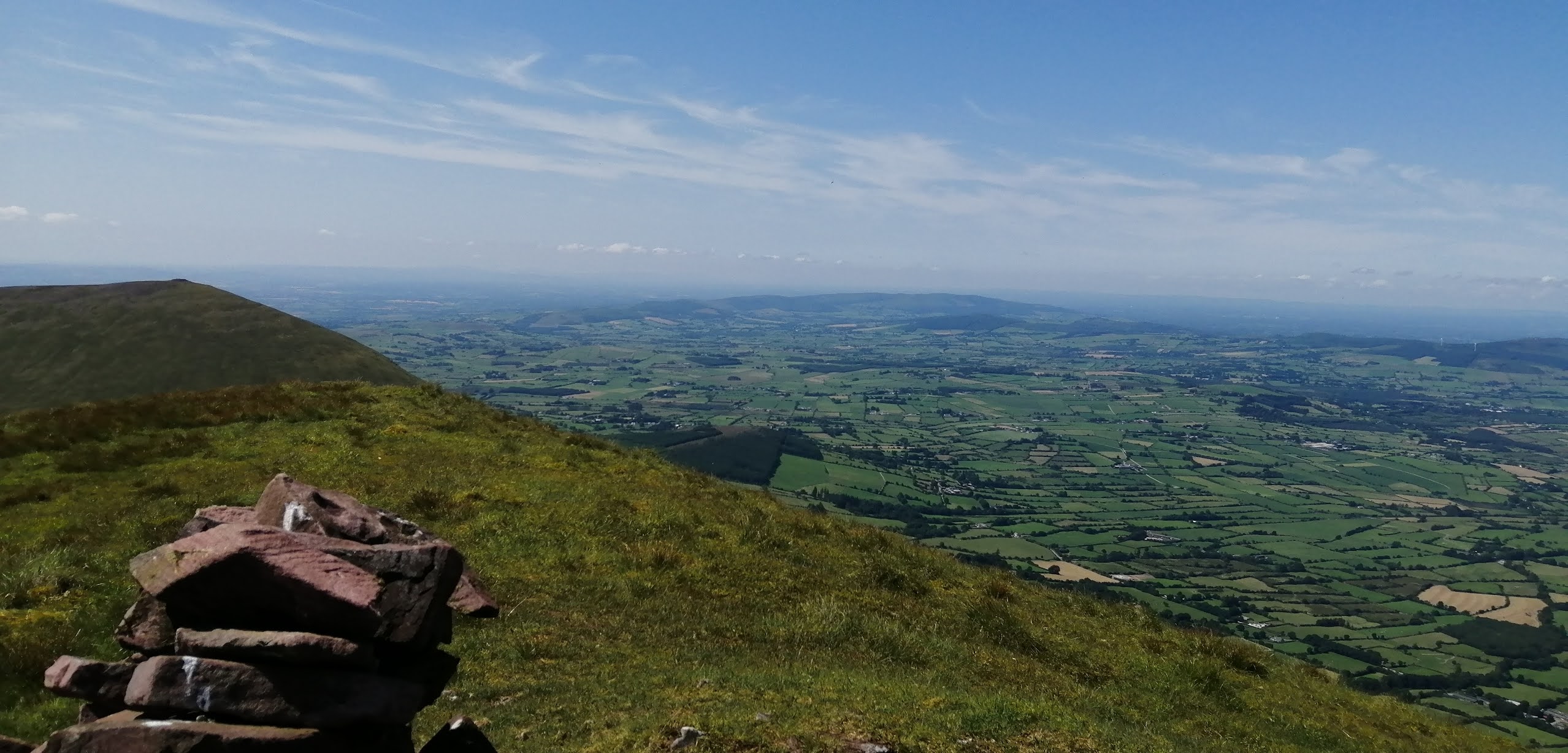
View to Brandon Creek and the Three Sisters
This section, in weather such as this, is simply divine. The views to the sea and back to Cloghane and beyond open up, and are wonderful, but the gnarly skyline of the main ridge of Mount Brandon is truly special. It thrills and excites, but first I had to get there. The glory of the spectacular sunken coum of An Sas is always special, but up next comes the near 500mtr climb to Masatiompán. It is a brute with the heavy bag, but it does pass. The rewards, in terms of views, are more than ample compensation. On top of all that, there before you, you now can gaze down to that majestic juxtaposition  of hills, coastline and islands, that is famous the world over. Not that all the climbing is over. Far from it, but the worst bit is done. There follows several wonderful kilometres as you approach and pass Brandon itself. After the big pull up to Brandon Peak, I could begin to think about reaching Ballysitteragh, where I hoped to camp for the night. I filled my water bottles from a young watercource near the boggy flat below Gerhane. Now, laden with the extra few kilos, all that was left was the 200mtr climb to the broad summit. Once there, I found that right beside the cairn was perfect for camping. It was a delight to drop the bag and I wasted no time in setting up my home for the night. Dinner soon followed and a delightful evening was enjoyed. It had been a very worthy start to the trek. 25 kilometres covered, 1900mtrs of climbing in 8 hours. I slept well. 


Looking at Ballysitteragh and that final 200 metre pull to the top.


The rough glory of the ridge as you approach Brandon

Saturday May 29th;

Nice view to wake up to.

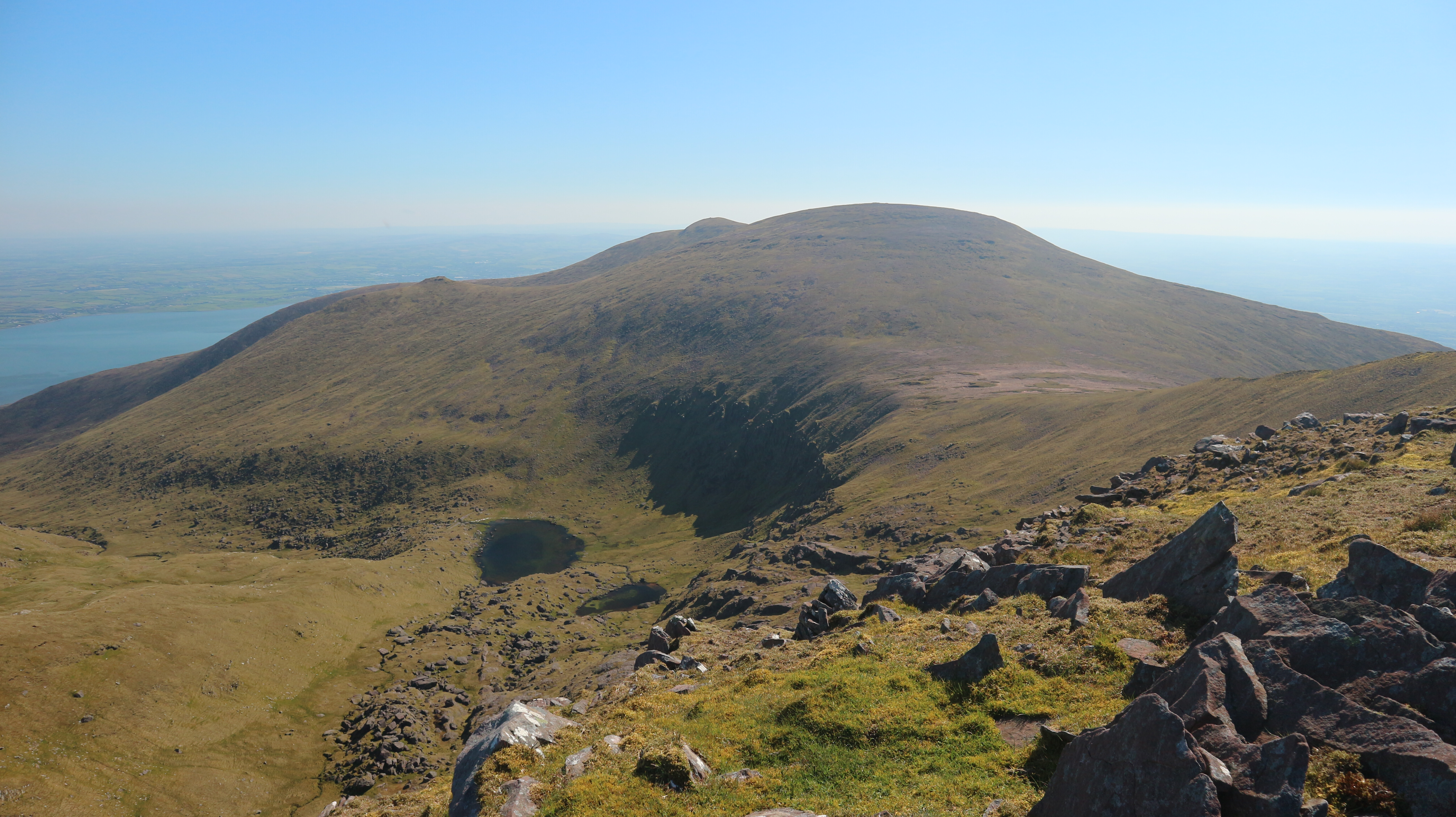
I was feeling tired this morning. It was an easy thing to snuggle in my warm sleeping bag and idle away some time. It was after 8am when I finally persuaded myself to get up. I emerged into another beautiful weather day. There was a little bit more cloud about and some extra breeze, but it was still near perfect. The plan for today was simple. Just head east. Once I passed the Conor Pass I had a choice to make. I could head for the line of hills that run on the southern edge of the broad bogland that stretches to Annascaul lake, or I could climb Slieveanea and Benoskee on the northern side. I chose the first option, as it gave, what seemed, the most logical and linear route. Neither option is easy. The southern option gives an easier route for the hills but entails a long, rising, semi circular traverse of trackless rough ground before you can continue over Dromavally Mountain. A good track rises from the Conor Pass and offers easy access to the first top of the line at Croaghskerda. This involves a short out and back but it is a superb viewpoint. Next comes An Cnapan Mor with its wonky summit cross. All nice and easy so far, but there is a considerable climb to reach Cnoc na Banoige. The final top of the ridge is Knockmulanane, after which a steep drop is needed to reach the aforementioned expanse of bog.

View as I near the Conor pass

On the ridge heading towards Anascaul


There is no easy way to get across this, but perseverance eventually pays, and I started the gradual climb to Dromavally. My legs were tired starting out this morning and they really didn't improve. I persevered but it felt hard. Boggy ground really saps the energy so it was a relief to reach the crest where easier ground was to be found. The huge megalithic cairn and standing stones were a lovely reminder of the ancient history of the place. I enjoyed a brief rest on the summit before setting off on the next leg of the journey. Even though the next section is the lowest of the traverse, it certainly isn't the easiest. For the next several kilometres the ground is wet and constantly crossed with peat banks, and the inevitable sodden holes between. The time was shoving on and I began to look for somewhere to camp for the night. Eventually, after I passed Knockbeg, I spotted a likely gully where I dropped down and filled my water bottles again.  Shortly thereafter, I spotted a dry grassy knoll and I headed for it. I once again had my home for the night. The evening wasn't as idyllic as last night, as just after dinner, the midges emerged in force, so I had to retreat into my tent. It had been another worthy effort with 28 kilometres covered, 1200 metres climbed in 8.5 hours. The rest was most welcome. 

Towards Benoskee. A big traverse of the bog needed to avoid the gap above Anascaul Lake

Still a log way to reach Caherconree

Brandon being left behind.

Ancient cairn and looking back the ridge I'd travelled

The next hills are lower but not any easier to cross. The Slieve Mish beyond


Day 1 map

Day 2 map

Sunday May 30th;

I didn't sleep as well last night but, strangely, I felt better rested. I got up at 6am so as to ensure sufficient time for the walk to Tralee. It was yet another wonderful morning. A nice breeze ensured that the beasties allowed me to breakfast in peace, and I felt in great form as I set off on the final leg of this trip at 7am. The couple of kilometres to the crossing point of the busy Dingle road soon passed, and after another easy couple of kilometres on a quiet lanes and forest track, I reached the first climb of the day. Nothing too desperate, but the 150mtr pull got the blood pumping, before a rough boggy descent saw me reach the road under Caherconree. This beautiful mountain looks its best from here. It rises impressively to the ridge high above, before rising to the lovely viewpoint and ringfort not far below the summit. There were several cars at the trailhead and I could see a couple of groups up ahead. I wasn't really looking forward to the 600 metre climb, but I consoled myself with the knowledge that after it was done, so was most of the climbing for the day.

Approaching the first climb of the day


Caherconree nearing and looking great

As is often the way, once you manage to keep putting one foot in front of the other and keep plodding along, ground is steadily gained, and I soon passed the groups when they stopped for a rest. One group, Indonesian or some such, actually had one person carrying a music player, so that for some time before and after I passed I had to endure its intrusion. I left them in no doubt about my displeasure. Anyway, to better things. As I got higher things only got more spectacular. The glories of the Iveragh Peninsula become more apparent and of course the immediate surroundings aren't bad either. Once I reached the remains of the ring fort, high on the shoulder of the mountain, the wind became quite strong and when I shortly thereafter reached the summit, I had to put on my jacket against the chill. Next up came Baurtregaum, which at 851mtrs, would be the high point of the day. The 150 metre climb is gradual enough and soon passed and I stood on the broad stony summit.  From there I headed for Glanbrack mountain where I rested and enjoyed a nice early lunch.


Looking way way back to the start.

Next up Baurtregaum

Being a couple of hundred metres lower than Baurtregaum, it was now less breezy and quite warm. The next few kilometres give easy walking, as you gently progress along the broad serpentine ridge. Since I had made good progress after the early start, I was confident that I would reach Tralee in good time for my train home. I could have descended towards Blennerville from several spots along the ridge, but I wanted to stay on the mountains for as long as possible. With that in mind I didn't turn from the ridge until after I reached the col beyond Baranageehy. The descent along the eastern side of the stream was initially pleasant enough, but the second half was a horrible, rough, super boggy, trackless mess, that had me regretting not choosing an earlier spur. Eventually I reached the Dingle Way trail and a blessedly easy descent followed to the road. Down here it was really warm, but the end was in sight and I was looking forward to coffee and cake in Tralee. A nasty kilometre on the busy main road soon passed, and then I was able to enjoy the remaining few kilometres into town alongside the canal. I reached the station at 14.45 so I had timed it pretty perfectly for the 15.10 train. It had been another substantial day. 28.5 kilometres covered, 1100 metres climbed in 7 hours 45 minutes. The coffee went down a treat.

Easy walking beyond Baurtregaum

The Killarney mountains ans the Reeks look great

A fair way to go but the end (Tralee) in sight

In Blennerville..Looking at the distant start

Overall I had covered 82 kilometres with just over 4000 metres of ascent in the 3 days. Stunning weather surely helped to make it a memorable experience. The sound of the cuckoo and the ever present delight of the song of the skylark was wonderful. I had been tired at times but overall the body is still strong. When it was all over I certainly felt a good sense of satisfaction and accomplishment.  And it was so nice to relax on the train. Perfect. 


Day 3 map.