
A fine weather window and a long weekend off work coincided and I took the opportunity to head west for a few days. The excellent Mannix Point campsite in Cahersiveen was booked for a few nights and I set off on a sunny Saturday morning. I was looking forward to today as I intended to do the Coomloughra Horseshoe. This is without doubt one of the finest hillwalks in the country and when I thought about it I was astonished to realise that I hadn't done it in a long time, I intended to put that right today.
Saturday July 27th;
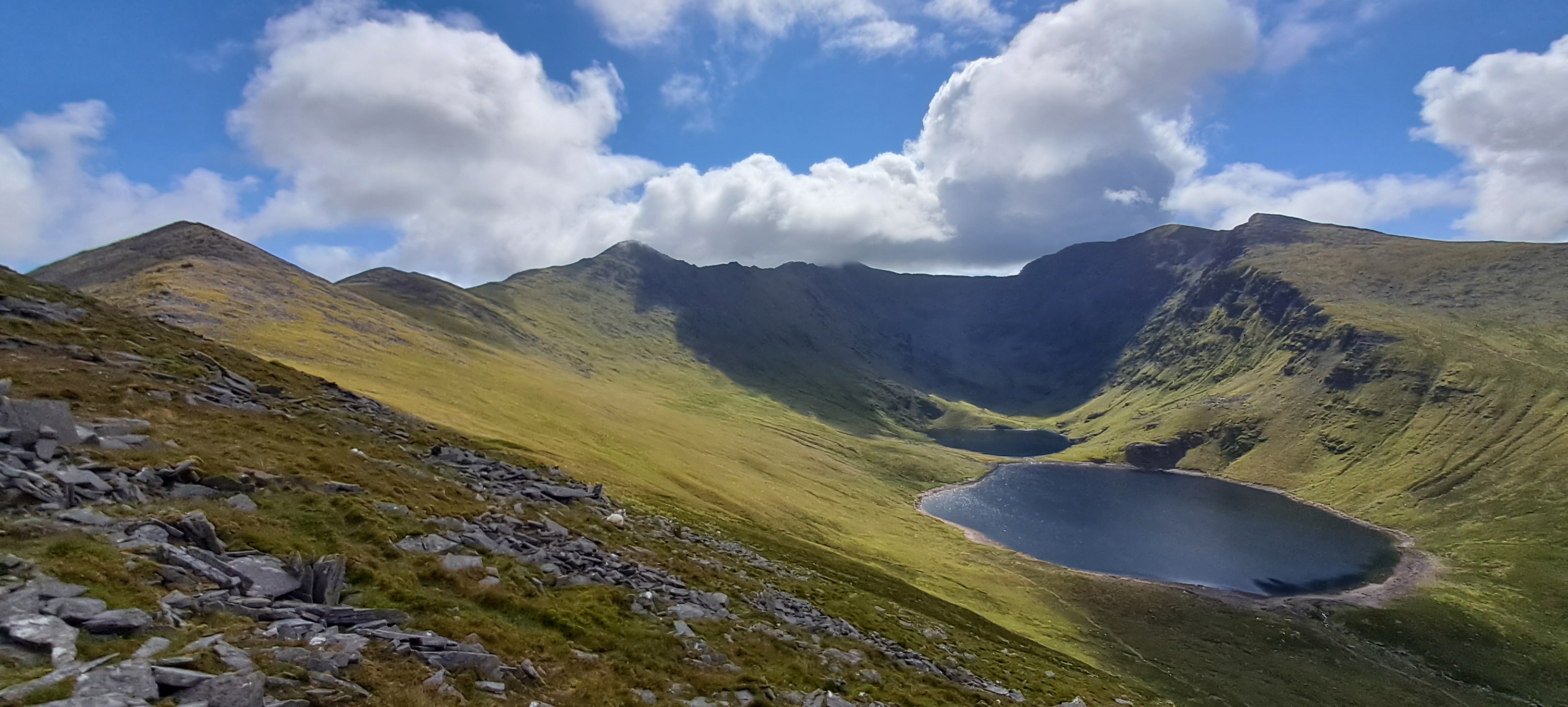
It was a beautiful morning when I left the car at 10.30 and it promised to remain so for the day. There was some cloud clinging to the mountain tops but I was confident I would be able to enjoy great views all day. As I walked up the "Hydro Road" I felt strong. It was lovely to be so unencumbered and just carrying a light bag. I thought back to all those years ago when I was starting out on my mountaineering journey and what a challenge this section presented to my overweight, unfit self. It used to be a major challenge to be able to keep walking without constantly stopping for a breather. Nowadays no such stops are necessary thankfully and I was able to keep a good pace up the steep track. The views open up as you rise and there is much to attract the eye as near and far everything is a delight. After the initial steep section the track turns right and the gradient eases and it is lovely to look west towards the mountains near Glenbeigh and across Dingle Bay the glories of the mountains of the Dingle Peninsula look wonderful. At the end of the "road" the full glory of Coomloughra is revealed and the three highest mountains in the country loom above you and present a picture of mountain perfection. From here a choice presents itself. You can go right and climb Caher first (this I think presents the easier option) or you can go left and climb Skregmore first, which presents a stiffer climb but offers an easier descent at the end of the day. I chose Skregmore.

 |
| Over Lough Acoose towards Glenbeigh |
Cnoc Iochtar (743 metres) looms above you at the start and looks steep but it isn't too bad and height is gained quickly on the trail. Once I was able to reach the sharp crest I enjoyed a little scrambling for a while until it peters out. Now I followed the crest to the top. Wonderful views are all about both near and far and it was great to pause and look about in wonder. After Cnoc Iochtar ( which simply means lower top or peak) there is a short drop before the 150 metre pull to the top of Skregmore (848 metres). I was loving my outing and before long I was approaching the summit of Beenkeragh (1009 metres) where I decided to stop for a bite to eat. The relative solitude that I had enjoyed so far today was now a thing of the past as I was soon joined by a couple of groups who arrived to the summit from the Hags Glen side. Across the void the summit of Carrauntoohil looked very busy. Up next is one of the highlights of the day, the exciting Beenkeragh Ridge. In truth it is very straightforward until the final section which is quite narrow and gives an airy scramble if you stick to the crest. I enjoyed this section and before long I reached the saddle at the top of O'Sheas Gully. A large group had just arrived here and I could see plenty more making their way up the final slopes to the summit of Carrauntoohil. I pushed on and climbed the final 100 metres to the roof of Ireland. Lordy me but the top was busy. Dozens of people milled about so I quickly left the hubbub behind and headed towards Caher. Thankfully the crowds were soon left behind and I enjoyed the delightful section that leads to the top of Irelands third highest top. From the airy top I looked towards Carrauntoohil and lines of people could be seen approaching the top. It was as busy as I had ever seen it. I enjoyed the straightforward descent and once I reached the "Hydro Road" I made swift progress to my car. I was very pleased with how I felt and I had covered the 13 kilometres and climbed the 1300 metres in four and a half hours.


It felt really warm down here but I felt great once I had changed into fresh clothes. The 40 kilometre drive over the stunning Bealagh Óisín was wonderful and not too busy and before long I was settled in the busy campsite. A bite of dinner and a few hours fishing for Bull Huss at Reenard closed out the day. It had been a good one.
Sunday and Monday 28th&29th July;
It was a beautiful weather morning and I was looking forward to "enjoying" a long run today. The marathon in Dingle is fast approaching so I really need to get some miles under the belt. With that in mind I planned to do a circuit of Valentia island, which would be around 21 kilometres. To get there I would take the ferry from Reenard to Knightstown. I decided to run to Reenard as well. That would give a total of 29 kilometres running. It went very well. Warm sun and wonderful views made it a joy to be out. I was pretty tired by the time I got back but all in all I was very pleased. Valentia island is always a pleasure to visit.
 |
| The view from the slate quarry. Worth pausing and taking it in. |
I could really feel yesterdays outing in the legs today. A pain in the groin area made me cautious about overdoing it. I really didn't need a muscle tear at this stage. With that in mind I decided to do the Beentee Loop. I set off from the tent and walked up the lane to reach the higher road above the town. I continued to the right and went up the spur above Letter to reach the summit. I should say that the weather was less glorious today and cloud veiled the tops and a stiff wind banished any memory of yesterdays warmth. The climb up the spur is steep in places but I was pleased that the legs loosened out and I made good progress. Once on the summit I followed the trail in an anti-clockwise direction back to the town. This is one of the best trails around and it goes along green tracks and trails all the way back to the town. I actually ran most of the way back and again I was pleased with how the legs felt. I was back in the tent by 13.30. A modest outing it may be but it was just the job after yesterday...13 kilometres and nearly 600 metres ascent.

Monday July 30th;
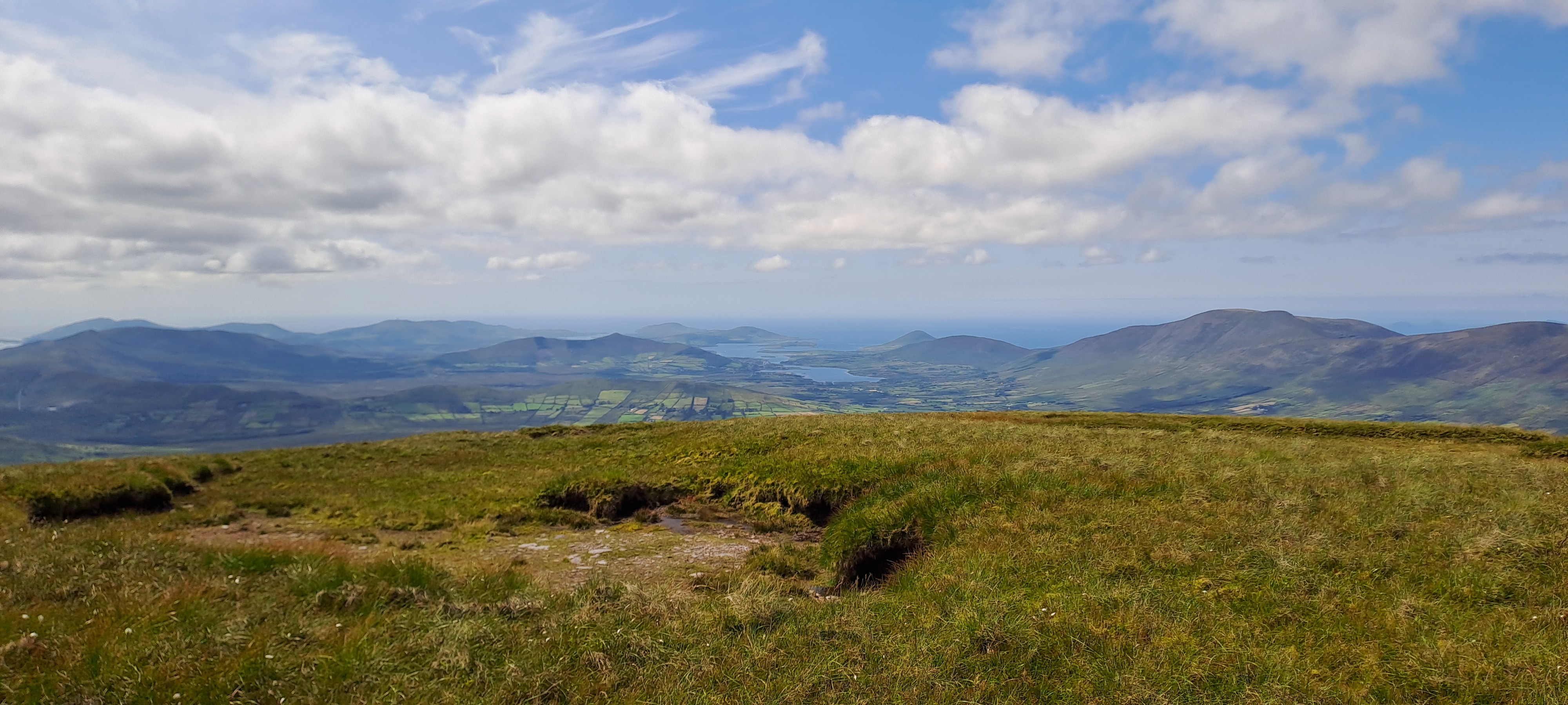
The dull misty weather of yesterday was thankfully just a blip and this morning was glorious. It was calm and sunny and was to stay that way for the day. I was looking forward to today. I planned to do a good hike on the Glenbeigh mountains above Lough Coomasaharn. Back in the Spring I had enjoyed a lovely outing when I climbed Been Hill and went around to Teermoyle and returned to the car. That outing had been the first time in a while when I was able to breath freely without the restrictions of asthma. Today I planned to extend that outing and follow the Kerry Way all the way to the shoulder of Drung Hill and include that mountain in the outing.


After the easy day yesterday I felt great this morning. I drove up to the road to near Kells and followed the lane down to where it meets the Kerry Way. I parked there and set off. I wasn't sure what the "Way" would be like but it was a delight for the entire six kilometres I was on it. It contoured under Been Hill and later under Drung Hill and it felt wild and remote. It would make a delightful section for a trail run. I left the trail where it contoured around a hump on the western spur of Drung Hill and headed up across the wet boggy ground to a saddle where an Ogham Stone stood. The views back towards Cahersiveen were especially lovely but everywhere was a delight. After a good drink of water I turned and tackled the steep 260 metre pull to the summit of Drung Hill. It went on a while but soon enough I reached the top. What a delightful viewpoint this place is. To the west the delights of the Dingle Peninsula are laid out across the blue waters of Dingle Bay and to the east the mighty Reeks look amazing. There is much much more but suffice to say that it provides one of the best places to relax and soak in the views in the country.
 |
| Teermoyle in the centre |
 |
| Towards Dingle and the Blaskets |
 |
| 20 kilometres away but the Reeks still look special |
Unfortunately my arrival coincided with the arrival of a group of boisterous teenagers who somewhat spoiled my reverie so I didn't delay and continued on the easy ridge to Beenmore where I enjoyed a bite to eat in splendid quiet and isolation. The views across the series of coums and lakes is truly spectacular. After my rest I descended easily to the saddle before the pull up to Been Hill. Then you go across the bog and peat hags to Mullaghnarakill, before another drop and climb towards Teermoyle. If the views up to now have been spectacular, then when you finally get to see the glories of the rugged coum that surround Coomasaharn Lake, the scenery is simply breath-taking. I was feeling great and enjoying everything that the day offered. Warm sun, no wind and epic views. I felt fortunate indeed to be able to experience it all. As an aside, once I left the young group behind I didn't see another soul on the hills. This truly is an undiscovered gem. Eventually I had to leave the edge of the coum behind and I walked to the wide featureless top of Teermoyle which at 760 metres would be the high point of the day. The long spur to the west makes for an easy and enjoyable descent and I was able to use a farm track to exit the mountain and reach the road. Now normally I'm not a great fan of road walking but the three and a half kilometres on these quiet lanes was a delight. The verges were a riot of colour with fuchsia, meadowsweet, loosestrife, wild roses and more vying for the most beautiful award.
 |
| Looking down on Coomasaharn |
 |
| Looking west towards Cahersiveen and Valentia |
 |
| A wild garden |
I arrived a very happy bunny at the car five and a half hours after setting off. The hike had covered 21.5 kilometres and had 1100 metres of ascent. All that remained was the drive home where the views just kept on coming. Kerry delivered yet again.
No comments:
Post a Comment