Saturday 26 November 2022

Leenane November 22


I was a flutter of indecision for days before I finally decided to return to the Leenane Hotel for a three night stay. My reasons for hesitation was the, frankly shite weather we were having and the forecast only promised more. That is until a couple of days beforehand things seemed to improve, so I bit the bullet and headed up.

Wednesday November 16th,

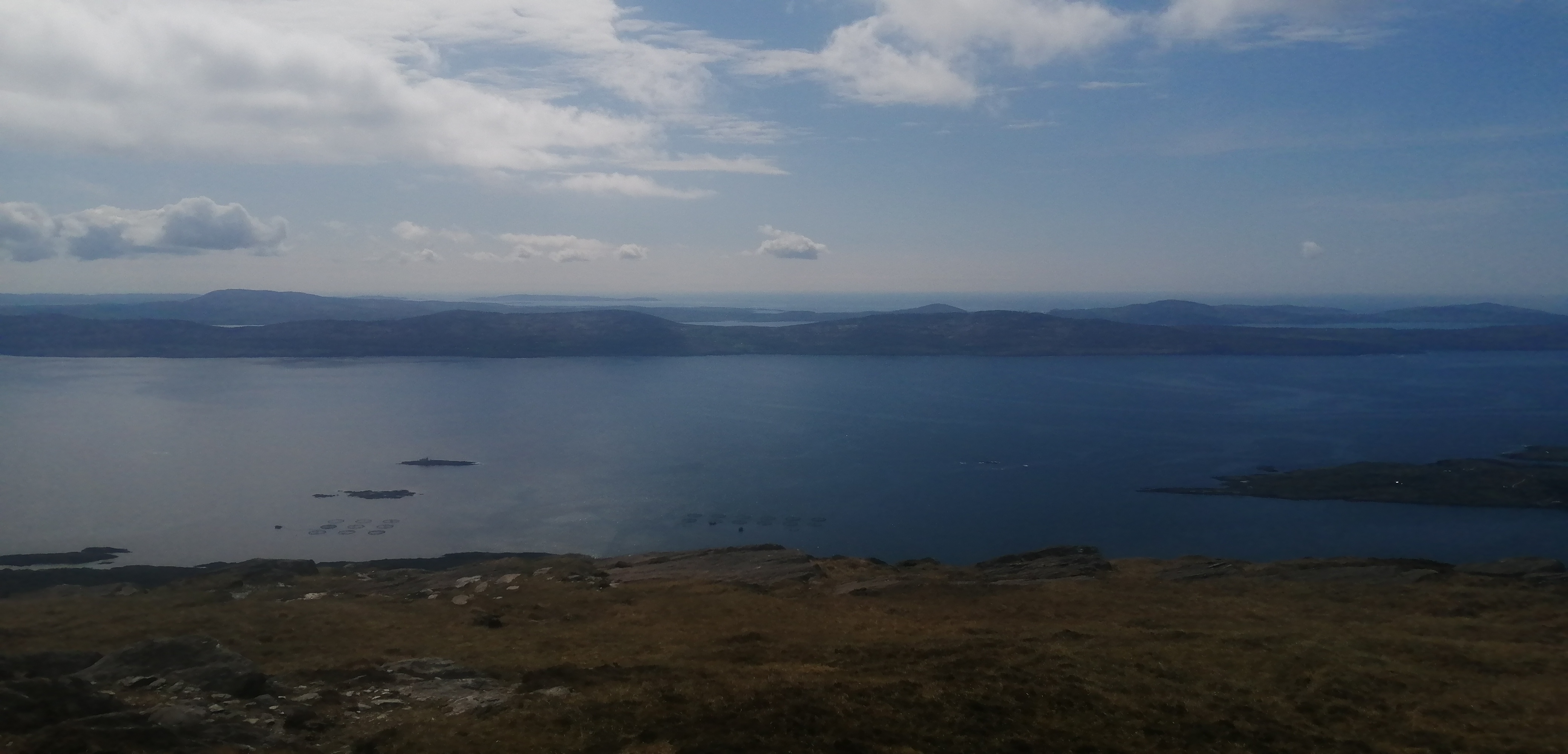
It was a chilly showery morning as I left home and faced into the 260 kilometre drive. The forecast was for it to improve throughout the day and that is what transpired. As is usual, when I got beyond Oughterard, I entered one of the most beautiful places in Ireland. Some clouds clung to the mountain tops and the odd shower could be seen, but overall the glory of Connemara was laid out before me and my anticipation for the trip grew. As it is such a long drive I had decided that I would "enjoy" a run today and keep the hillwalks for the following days. I opted to do a route I had done before, which ran along the shore of Killary Harbour, before returning via the quiet road that cuts under the Bencoonagh Mountains. This would offer either a 16 or 20 kilometre circuit, depending on which route I took at the far end. I drove past the hotel and parked the car down in the valley near the end of Lough Fee.

It was just about 12.20 when I started so I had lots of time. At least that was my excuse for the leisurely pace I set. I was determined to enjoy it. After a short time on the main road I turned onto the lane that heads for Bunowen. This delightful lane leads right to the water's edge and is a joy to trundle along. Add into the mix the glory of the mountains of the Mweelrea massif, plus the wild ground on the left and it is a heady mix. After perhaps four kilometres you pass a shellfish processing plant ( the harbour is a big producer ) and then the lane becomes a green road before finally dwindling to a rough track. I was quite pleased with how I was doing as I haven't been doing much running, but as I said, I was taking it steady. A delightful stretch followed until I reached Rosroe pier where once again I reached a tarred road. This runs alongside Little Killary before you reach a stiff climb at the waters end. I was feeling pretty good so I opted for the longer option and I turned right and headed to Glassilaun. 

Looking west along Killary

Looking inland

Back at the car

Wonderful views to ease the pain

As is sometimes the way, not long after deciding on the longer option I started to feel quite tired. By now I had thirteen kilometres done but seven more remained. I did enjoy the wonderful scenery all way back to the car, but it is fair to say that the final few kilometres became increasingly tough. By the time I reached the car I was wrecked. I wasted no time in changing into warm clothes and I had a bite to eat. Thankfully the drive to the hotel was short and check in seamless, so before long I was enjoying a wonderful long hot shower. Bliss. I chilled in the room until six pm when I went and enjoyed an excellent dinner. I then drove back to Glassilaun beach where I enjoyed a few delightful hours fishing. The fish were obliging and the time flew by. A good nights sleep followed a pretty full on day.

Thursday November 17th,

I was looking forward to today. After eating too much for breakfast I left the hotel and began my hike at 9am. It was mostly clear skies and it was forecast to be sunny and calm until dark. It came as a bit of a shock to see rain drifting over the mountain across the water and before long it reached me. Just as I reached for my waterproofs it stopped so I walked happily on. Today I planned to walking along the Western Way until I reached Letterbrecaun and then climb it and follow the ridge back and over Leenane Hill to reach the village. I had done this hike once before almost two years before. That time it was a wet and cloudy all day with nothing in the way of views. 

A fabulous section of the Western Way nearing Letterbrecaun


Today I was hopeful for better things. Despite the early spit of rain the morning was looking really good and the mountain tops were mostly clear. After a few hundred metres on the main road, the trail heads left and contours around the hillside through wild and wonderful ground. Everywhere is a delight for the eye. After a few kilometres you enter forestry land and the wilderness feel is lost, but the views remain great. As you progress through the woods you are reaching the glorious Inagh Valley. The splendour of the Twelve Bens is revealed more and more as you get nearer, but what looms ever larger is the wonderfully shapely ridge that drops steeply from Letterbrecaun into the valley. Once you leave the woods the trail heads directly towards the base of the climb.


Across the Inagh Valley towards the Twelve Bens


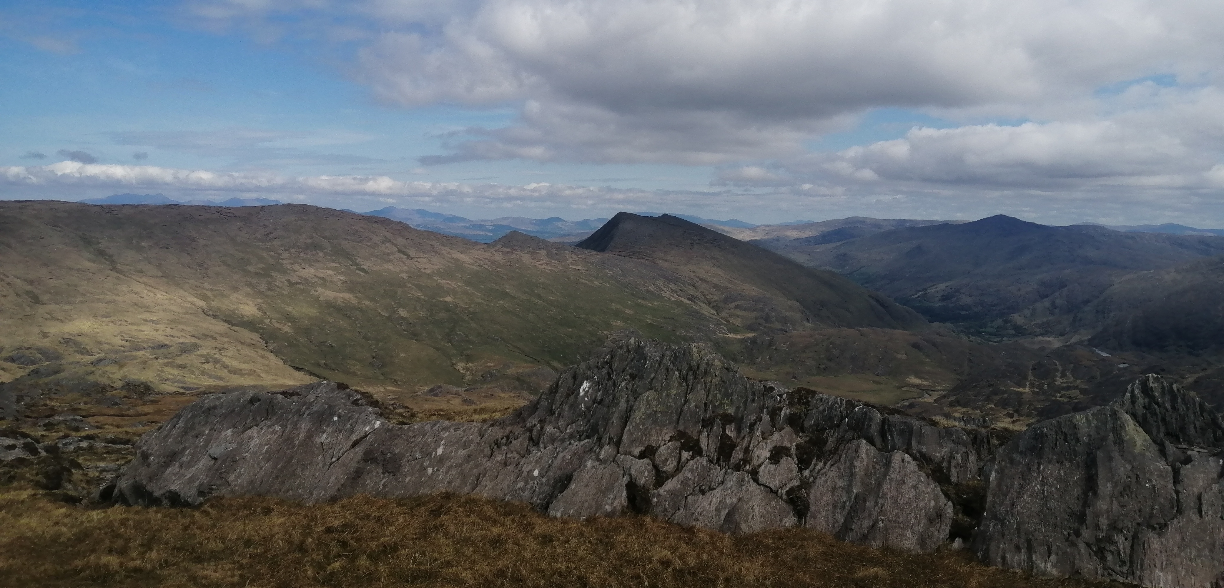
It is a full twelve kilometres to reach Letterbrecaun. By the time I reached it the weather was perfect. I wasted no time in starting up. That's not to say I rushed. I took it slow and steady and once you manage to keep going, height is gained quickly. The middle section is the steepest and offers some scrambling of varying difficulty. By keeping mostly to the left difficulties can be avoided. The 600 metre climb went well. I'd love to say that it flew by, but the final section seems to just go on and on. Still, the reward of standing on the deserted rocky summit, with those incredible views, soon had me forgetting the effort to get there. I rested for a little while before starting along the ridge for the return journey.

Mountain water and sunny days

The broken rocky nature of the ground makes good concentration a must as you head towards the northeast top. After the descent from there, the ground becomes turfy and grassy and easier. That said, the descent into the gap under Binn Bhan is steep and requires care. The views in all directions were a constant delight and I found myself taking more pictures than I had in ages. It was only a few weeks before that I was hiking through the Alps, and I truly felt that the scenery today was a match for any I saw during that hike. The serpentine ridge eventually drops to just 250 metres below the final climb to Leenane Hill. This meant a long 350 pull to reach the broad boggy top. On the way up I could see some rain coming in from the sea. Miraculously the rain entered the valley on either side of the mountain and I stayed dry all the way back to the hotel. It had been a great outing that I had enjoyed immensely.

Almost back in Leenane

The Mweelrea Massif


Looking east towards Maam and Lough Corrib covered in cloud

The Bencoonaghs

 25.5 kilometres, 1400 metres ascent in just shy of 7 hours. That shower was put to good use again.

Friday November 18th;

The forecast for today was very good again so I decided tha another hill walk was just the job. I was feeling surprisingly good after yesterday's outing and I toyed with the idea of doing Mweelrea today. That would mean another big outing and would leave little time for anything else. As I wanted to do some more fishing I opted instead to head to Murrisk near Westport and climb, one of the most famous mountains in the country, Croagh Patrick. I had never climbed it and this seemed too good an opportunity to miss. It was a beautiful morning and I really enjoyed the scenic drive. I was parked and on the move for 09.30.


The lovely conical summit beckons

Clare island

It was very quiet, with only a few cars in the large car park. I carried an almost empty rucksack and had just trail runners on my feet as I knew that there would be a good track most of the way. I set off at a good pace and soon I was climbing steadily up through the mountainside and enjoying wonderful views. Croagh Patrick is a very shapely mountain. The summit is a pleasing cone shape and as it rises from the sea shore it is big and imposing and dominates the landscape for miles around. At 764 metres it is not the highest mountain in the area but every metre is climbed so as to reach the top. It is basically an l shaped climb. The whole mountain is basically one long ridge that runs east to west, with the main summit rising over 200 metres from this. The climb is an l shape, running pretty straight south until it reached the crest of the ridge at the 500 metre mark. It then traverses easily west until you reach the base of the cone and begin the final part of the climb. This being a so called "holy mountain" it attracts many thousands of people who come as pilgrims to climb it each year. Indeed, on the last Sunday of July, as many as 25000 people turn up to climb it, and this is a major logistical event for the various rescue and civil bodies. Thankfully today it was quiet and felt more like a normal outing.
Clew Bay

South from the ridge

Towards Mweelrea and the Sheefry Hills

Initially the going is easy, but up at around the 300 metre mark the track is rough and eroded and steepens to about 25 degrees. It is however wide enough that you can zig zag if you wish. I passed a few women who were having a fine old time, if the chat and banter was anything to go by, and once I reached the ridge I basically had the mountain to myself. A delightful kilometre passed on the ridge and here I was able to enjoy views to both the north and the south. Some showers of rain misted across the expanse of bog to the south and lit by the sunshine the whole effect was lovely. The views were as delightful as I hoped and everywhere I looked was a joy. At the base of the cone the trail steepened and an excellent path is built most of the way to the top. It didn't take too long to reach the top, "adorned" as it is by a church and "St Patricks Grave" which is strewn with tokens of memory and superstition. Some cloud and sleet arrived and tried to spoil the views and this coupled with the stiff cold wind meant I didn't linger and headed back down. It didn't take long to reach the again and here I met more people, including a couple of young men who were doing the climb barefoot. I was back down at the car in less that two and a half hours. It had been a short but very pleasant outing of less than 8 kilometres and 750 metres ascent.

Summit oratory


I went to a nearby beach to try my hand at a spot of fishing. It was windy and the rain showers became more frequent. I did catch a whopper of a flounder but also lost five rigs, so it was an easy decision to cut the session short and head back towards Leenane. I returned to the hotel via the Louisburg/ Doo Lough road and it was once again a joy. The section that approaches and passes Doo Lough is, in my humble opinion, the most beautiful drive in the country. I didn't stop to take pictures, but instead drove very slowly along the deserted road and savoured the experience. Everywhere in that neck of the woods is truly beautiful.

Saturday November 19th;

All good things must end and today I had to head back home. The good weather was also to end, with rain and wind the offering for the day. It was forecast to arrive at around 10am so I was hoping to get a swift hillwalk in before heading home. Check out was up until midday so I wasted no time in setting off after a swift breakfast. I decided that the nearby Devilsmother would make a suitable outing. I was on the move by 08.30 and it was a pleasant morning. The sky was cloudy but the tops were clear, and while there was a stiff breeze, it remained dry. All and all not a bad start to the day.

After a kilometre and a half on the road I made my way onto the open mountain. The going is initially steep but after a while the gradient eases back when you gain the crest of the long broad ridge. Up at the 230 metre contour there is a nice 1.5 kilometre flat stretch which I jogged along. I was conscious that time was limited and that I needed to be fairly swift if I wanted to have a shower etc before heading home. It is four kilometres from the road before you reach the saddle under the climb to the summit, so todays outing is a fair bit longer than yesterdays. I needed to be finished in three hours. With that in mind I put in a good effort on the 300 metre climb to the 645 metre summit. Mind you I recieved some help from the strong wind which pushed at my back on the way up. It was also threatening rain and this duly arrived just before the top. I was still below the cloud and the land looked wild and windswept. It made me appreciate all the more the good weather of the previous days. The descent is initially quite steep and some care was needed to keep control as I jogged downhill. Sodden ground and a buffetting wind ensured I kept maximum concentration. The steep ground gives way to a broad easy ridge that descends steadily to the road at the innermost reaches of Killary. I kept up a steady trot the whole way down and soon I was once again on the road. I now had nearly four kilometres back to the hotel so I kept up a gentle trot all the way back and I arrived drenched, tired but equally delighted into the hotel at just 11.10am.

Even on a dull morning Joyce Country looks great

Lough Finny and Lough Mask beyond

Starting up the hill..the hotel nestling under Leenane Hill

It had been a  near 14 kilometre hike with almost 700 metres ascent, and I was very pleased to have done it in just 2 hours 36 minutes  It was great to enter the room and get out of the wet gear before a final shower and change into clean dry clobber. I even had time to enjoy a coffee and cake before checking out and beginning the long drive home. Hotel life is without doubt a very civilised way to enjoy the mountains.


Wednesday 11 May 2022

Back to the Beara. Cycling and Hiking.


 I had a week off work and I wanted to head away for three or four days but I struggled with my usual indecision on where to go. After much mulling things over I headed back to Castletownbere and decided to sample the delights of the Beara Peninsula once again. 

Sunday May 1st;

I'm not a huge fan of heading away on bank holiday weekends, as I tend to prefer the quieter less busy times, but needs must and the good weather that was forecast was too god to miss. Not only do I struggle with making the decision about where to head, but I also struggle with the choice of what to do when I get there. I kept nearly all my options open and packed up my hiking, cycling and fishing gear and set off west. The forecast for today was less than stellar, with light rain promised for much of the afternoon. I had kinda decided to fish for the day, but on the way down the day was actually quite nice so I decided that a bike ride around the beautiful Sheeps Head would be just the thing. Decision made , I was now looking forward to it. Alas as I neared Bantry dark low clouds filled the skies an it started to rain. It was however a brief affair. I drove to the far side of town and donned my cycling gear and readied for the off. Once again some rain made an appearance but I was ready now so I set off anyway. The route starts off nice and easy and undulates along a quiet road on the northern shores of the peninsula. Even in the gloomy conditions it was lovely and, as the rain had once again stopped I was thoroughly enjoying the trip. The first major difficulty is when a steep climb of the hill before Kilcrohane needs to be surmounted. It is not over long but at times it is in double digits in gradient, plus it was into the breeze. My heart was certainly pumping as I gratefully reached the crest.

If the ascent was tough, the descent was rapid. Perhaps a little too much so as the back of the bike fishtailed while braking when I met a car on the narrow road. No harm done however and once I reached Kilcrohane I turned right and headed along the ever more wild and beautiful road as it headed for the western extremity of the peninsula. Soon the landscape and the seascape become wild and even more delightful. By the time you surmount the steep short climbs to reach the roads end at Ballyroon you definitely feel that you have reached a special place. Today though I was relying on my memory for the sea views as here, the cloud had descended and all was enveloped in mist. Strangely it was none the less special because of that. A short rest and drink of water and I turned and headed back along the way I'd come. Now I was with the breeze and the road all the way to Durrus promised to be faster and easier. It was a very enjoyable return and it felt good not to have to struggle with the breeze. There are no hills on the route as you mostly follow the shoreline to the little village of Durrus which nestles at the eastern end of Dunmanus Bay. A steady climb from here followed before a fast return to Bantry and the car. Remarkably I had stayed dry the whole way and the rain returned once I had gotten changed. A total of 65 kilometres and 750 metres of ascent eased me into the holiday nicely. The Sheeps Head is wonderful.

I went and pitched my large tent in the little campsite on the golf course.The rain eased again in the evening and I spent a couple of hours of less than productive fishing at the adjacent pier but it had been a good first day.

Monday May 2nd;

The next few days were supposed to be very good weather wise and emerging from the tent to a calm sunny morning was certainly a good start. I decided that such weather merited another cycle. First up was a quick visit to the little lug bed in Castletownbere, where I spent an hour digging a good supply of bait. Once back at the tent I donned the old man in Lycra kit and headed off at 10.45. I decided to do a decently long cycle today and set off initially for Allihies. It is a nice easy start until the first climb at Gour, which got the heart pumping, but it was early doors and I was feeling pretty good. The weather was wonderful. Sunny, a light breeze and while not warm, it wasn't cold either. Add to this, absolutely stunning scenery and it's easy to understand why I was having a great time. Another climb to the gap before Allihies gave a good excuse for a little rest and drink while I took in one of my most favourite views. The road from here to the top of the climb out of Gortahig is narrow, twisting, undulating and equal parts wonderful and exhausting. It includes a couple of particularly tough climbs and once at the top of the final one, another rest was required.

Always worth a stop to look at Allihies

Next up is the long relatively easy stretch as far as Lauragh. Major roadworks had closed the road outside Eyeries but I ventured ahead anyway and with some care I was able to get through. Indeed, where they had finished the road offered an improved surface and the section before Ardgroom was it's usual gorgeous self. Not that the rest was too shabby. Views were wonderful all the way. As I neared Lauragh I was starting to feel a bit tired and the looming Healy Pass weighted heavy on the mind. I wasn't over confident of flying up it. I turned onto the narrow road and faced into the 5 kilometre climb. It started well enough and the first couple of K went pretty well. I knew however that I was beginning to struggle. Once I reached the higher section I was beginning to bonk, and let's just say cresting the final section was pretty awful. I didn't pause for a rest and instead tried to use the long descent to recover. I wasn't feeling too bad once I was down in Adrigole and I turned for the final 11 kilometres. The first few kilometres went reasonably well but the short hill at Derreny finally did for me and it was a pure struggle to complete the final stretch. Strangely, it was as much my arms and chest muscles that were spent as it was tired legs. I guess I stood on the pedals during the climbs too much. The hour digging probably hadn't helped either. A good feed and a warm snooze in my sleeping bag went a long way to restoring me.

All told it had been an 82 kilometre outing and included nearly 1200 metres of ascent in 3 hours 40 minutes.

I ventured to a new fishing spot for me in the afternoon, just a couple of hundred metres from where I dig the lugworm.. It was a short and unproductive session. It was still a delight to bask by the water and soak in the sunshine and the views.

Tuesday May 3rd;

It was once again a lovely weather morning and after my struggles yesterday on the bike I decided that a hillwalk would be just the ticket for today. The delights of Hungry Hill lie about 6 kilometres from the golf course and I mostly decide to drive to the base of the west ridge and begin my hikes from there. Today, I decided to start from the tent and this meant a three kilometre hike up a quiet narrow little lane to start the day. Normally I'm not a fan of walking on roads but I have to say, with the hedgerows bursting into life, wildflowers in profusion and an accompanying score of birdsong, I loved every step. The three kilometres is also all uphill so by the time I was able to join the Beara Way and turn towards Hungry Hill I had gained 200 metres. It was a joy to be out and I must say it felt so much more relaxing than yesterday. Three more kilometres followed along the way until I reached the base of the mountain. The view of this wild and rugged mountain always inspires. I decided to miss out on the bottom section of the ridge and joined it about one third of the way up where the largest cliff section is to be found. I picked my way up the steep ground and at times enjoyed some fine scrambles and other times avoiding the hardest bits. This is a route that offers something for everyone. After climbing up through a narrow chimney the hardest bits are all done and soon I reached the easy ground of the south top. This offers an incredible panoramic view and I basked a while in the sun and enjoyed a bite to eat. 

Heading for Hungry Hill

Summit views.


The main top is easily reached and then I turned towards the rough ground that leads to the next top of the day Knocknagree. In the past I have found this section harder than it should be as it is easy to get drawn too far to the left too soon. The way isn't always straightforward, but the secret to an easier traverse is to stay high on Hungry Hill for about 500 or so metres north of the summit and then begin to track west to the ridge from there. The recent dry spell had made the going considerably easier and it was possible to walk directly across areas that at times would be very wet. The 200 metre steep pull to Knocknagree is a good test but once up here then most of the hard climbing is over. I paused for a short while to again soak in the views before I headed for the final top of the day, Maulin. There is some steep ground to be negotiated before you reach the col under Maulin but again the secret is not to try and go down too soon. Walk easily northwest for around 500 metres and then it is much easier to reach the col. Once again I appreciated the dryer than normal underfoot conditions as I crossed to the slopes of Maulin. Now a straightforward 160 metre pull saw me reach the broad top. A really easy descent to reach a bog road that led easily back to the lane I started on. This I once again enjoyed strolling down and I arrived back to the tent a very content boy with my day.


A respectable total of 22 kilometres in 5 hours 45 minutes with over 1200 metres ascent.

Once again I went for a short fishing session before dinner. Once again I didn't catch anything for dinner. It was however a beautiful place to while some time away..


Wednesday May 4th;

You can't beat a sea voyage to start the day.


The weather was again excellent this morning and I got up a little earlier so as to catch the 8am ferry, from the jetty adjacent to the golf course, to Bere Island. A place I have long thought to visit. The very pleasant 20 minute trip saw us dock at sheltered Lawrence Cove on the eastern side of the island. I wasn't sure what to expect, but it seemed a little busier that I expected, with more cars about. Perhaps I overstate it a little but I was passed by six or seven cars in the first few minutes of my walk. I planned on doing a loop of the western end of the island and this meant I had to do the first couple of kilometres along the road. Not that this was a hardship, as once I was away from the village of Rerrin, all I had for company was birdsong and flowers. The road initially went through some shady scrubby woodland before climbing along the hillside until I arrived at a wide pass between two hills. I went up to my right to have a look at the impressive Martello Tower that sits atop the first hill. This old British fortification is one of five on the island that were built so as to guard the strategic Bantry Bay against a French invasion in the early 19th century. Indeed the whole island bears the marks of history, and old barracks and gun placements can be found at the extremes. From the tower I followed the Beara Way markers across the pass and climbed easily to the large cross that stands on Knockanallig (267mtrs), the highest hill on the island. I stopped a while and gazed across the sound and I could see my tent and car at the golf course, and above that lay the delightful vista of the ground I had hiked yesterday.

Looking across at yesterdays hike.

Looking East

Standing stone

Martello tower.

From here on things become ever wilder. I wasn't really sure what to expect, but I was a little surprised and delighted at the expanse of remote hilly ground that swept away to a series of bays and headlands. It invited me on and I didn't hesitate. I dropped towards the rather lovely Doonbed Head and then turned and crossed pathless ground towards the twin heads of Shee Head. It was so beautiful. With blue skies and seas, bathed in warm sunshine, and not another soul in sight, I was in heaven. I climbed up the hillside and joined the trail once again and followed this easily to the spectacular Arnnakinna lighthouse. I stopped here for a little while and gazed across the channel where the wild extremes of the Beara Peninsula stretch away to the west. There is a delightful green road from here that you follow towards Derrycreeveen and once again return to inhabited land. Now, after 8 wonderful and wild kilometres, I was once again on the road. It was about 7 kilometres back to the ferry so I decided that it would be as easy to run it as walk, so I set off at a very gentle jog. I felt good and enjoyed the return route and the road went across the northern side of the island. It went through a couple of little hamlets and was mostly shaded and lots of while and blue bluebells adorned the hedgerows and more. I arrived back in Lawrence Cove a comfortable 20 minutes before the ferry was due to depart and it felt great to sit and relax and dwell upon a delightful outing on a magical island. 

The wild and wonderful west


Shee Head and Doonbeg Head with the Sheeps Head and Mizen Head beyond


20.5 kilometres, 600metres ascent in 3 hours 45 mins.

Since I was back at my tent by lunchtime, I had plenty of time to once again do some fishing. This time I went to Dunboy, where I have had less than good success, and try my luck from there. It was great to relax and look across the water at the lighthouse where I had been a couple of hours earlier. This time I managed to catch some fish, the best being a beauty of a pollock which was almost 60 cms long. Great sport.


Thursday May 5th;

I was heading home today. The morning was cloudier that the previous few but it was dry and there was only a light breeze, so I decided that a cycle would finish off the trip nicely. After struggling so much near the end of the cycle on Monday I decided to take it a bit easier and do a shorter cycle. A circuit of the western end of the peninsula in the opposite direction to which I went Monday route of choice. Even though it is less than 50 kilometres in length, the hills were still as steep, so it wouldn't be a piece of cake.


An easy intro into Castletownbere to start, before a steady pull to the pass before Eyeries follows. The climb was interrupted when I came up behind a few stopped vehicles because a van had hit the ditch. It was only a minor shunt and after a few minutes the road was clear and I was able to continue on. The going is straightforward until you reach the climbs either side of Gortahig. The first one isn't too bad but the second, though only a kilometre in length, is pretty brutal and reaches a gradient of nearly 20% at one point. The remainder of the way to Allihies is not easy. Steeply up before steeply down and constant twists and turns meant that if I wasn't pumping up the hills I was hard on the brakes. The scenery is however gorgeous and helps to distract from the rigours. Another steep climb out of Allihies follows before a delightful section where I was able to relatively relax. Another climb, this time more gentle, to Gour and then it is straightforward all the way back to the tent. It was an ideal end to the trip. 

49 kilometres and 720 metres ascent.

I packed everything up before a shower of rain, good timing, and drove to the beach near Bantry for a final spot of fishing. It was once again not very productive but in enjoyable none the less. I drove home a happy chap.