Wednesday 13 April 2022

A Wonderful Couple of Days In Cloghane..Benoskee and Brandon


Saturday April 9th;

 Saturday finally arrived and after 11 days in a row at work I was very glad when a couple of days off, and I could head away. I couldn't make my mind up where to go and I had kinda decided that I would head to The Reeks and Rossbeigh, however as I drove back I decided to head to Cloghane instead and I booked myself into the excellent Brandon Hostel for the night.

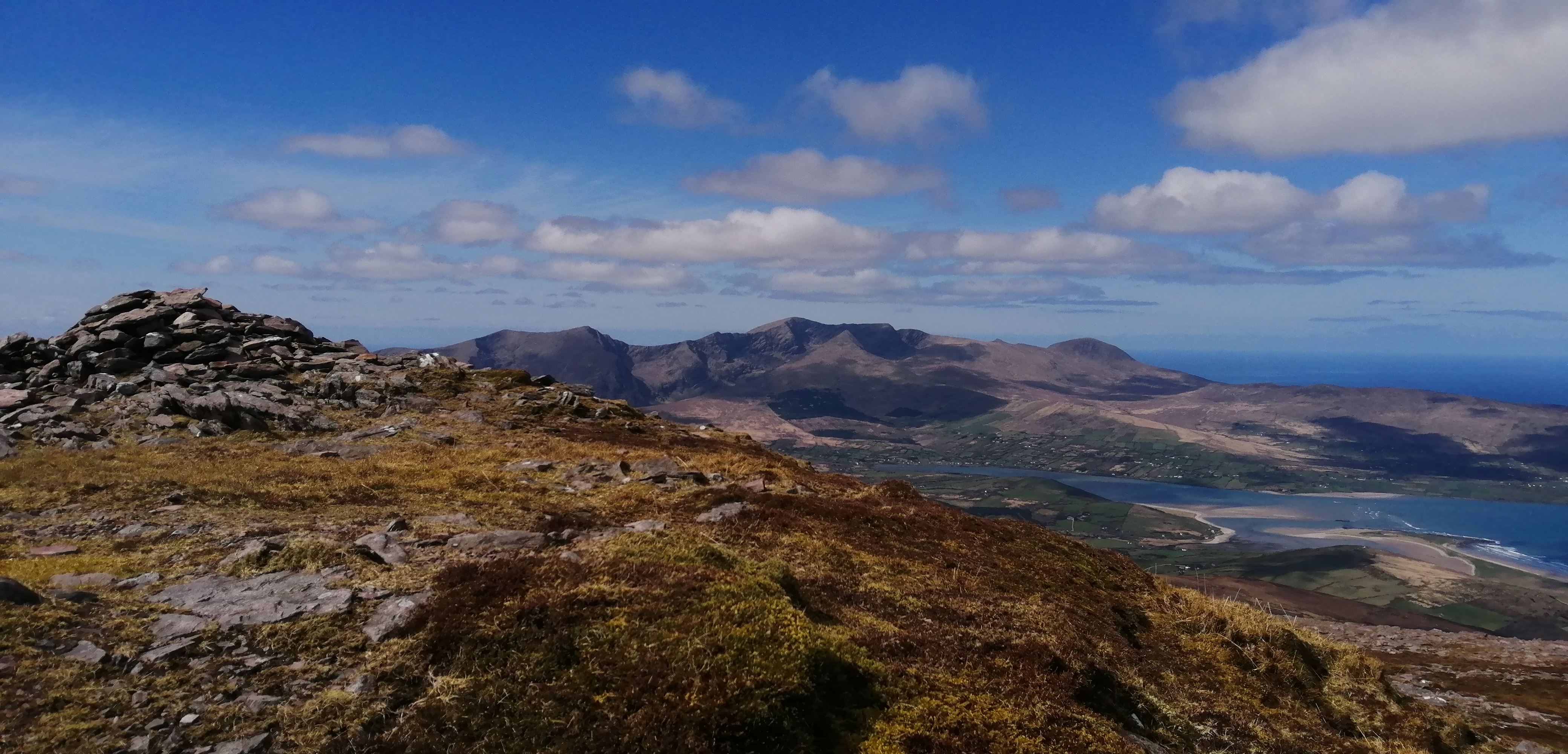
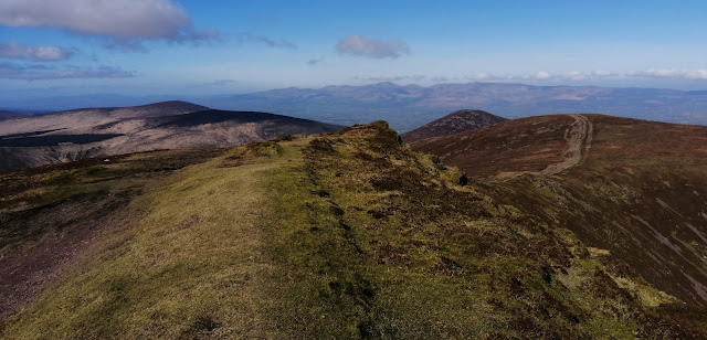
It was a beautiful morning and it promised to stay fine all day. Tomorrow was supposed to be windswept and rainy, so I was determined to make the most of today. As is usual the sight of the wonderful mountains in the Brandon area was breathtaking. I formulated a plan as I drove back and decided to do a hike up Benoskee first, check into the hostel in the afternoon, and once I had dug sufficient bait, to fish Fermoyle beach until after 10pm. It promised to be a full day. I parked at the junction for Cloghane and after a three kilometre walk along the road I was able to finally gain access to the beautiful valley on the western flanks of Beenatoor, an outlier of Benoskee itself. A good track enters the valley and in the sunshine everything looked wonderful and the nearby woodland was full of birdsong. I was immediately enchanted. The easy going didn't last for long before I turned and commenced the long, steep near 500 metre pull to the top of Beenator. This certainly got the blood pumping but I was feeling quite strong and I made good progress. The calm of the valley was replaced by a chill breeze as I got higher and this added incentive to keep moving. From the broad boggy top there is a gentle drop of 70 metres before a gentle climb of 90 metres saw me reach the next top Coombane at 610 metres. This offers a great place to relax a while and take in the super vistas on display around you. The Brandon massif looks stunning, jagged and spectacular as it rises from the blue shores of Brandon Bay. The Maherees stretch out into the deep to the north and of course the bulk of Benoskee looms large nearby. Next up came the 300 metre climb to the 820 metres summit.This is not too bad as it isn't too steep and the ground is pretty solid underfoot. The odd patch of snow and ice was to be found in shady nooks and that, coupled with the strong cold breeze, told that winter hadn't fully retreated just yet. I found a sheltered spot at the summit to have my lunch and savoured much more than the food. Up here the views were to be found in a full 360 panorama. Loop Head in Clare speared the ocean way beyond the Maherees in the north. Baurtregaum and Caherconree looked majestic as they buttressed the eastern side of the peninsula. The mountains of the Iveragh Peninsula were neatly arranged over Dingle Bay and I could even make out Mount Hillary away in the distance.


I have seldom enjoyed myself more on the mountains and it wasn't over yet. I now had over 950 metres ascent done, so the bulk of the climbing was done for the day, but there was still a few climbs in the offing as I planned to cross over each top that lay between me and Slievanea. The descent to reach the long boggy area between the hills that overlook dingle Bay and the tops I was doing that looked over Tralee Bay is straightforward. Down here, over 400 metres lower down, it was once again warm in the sunshine and the breeze was light. The recent good weather had dried somewhat the normally drenched ground, and it was easy enough to head towards the first top Beenbo at 477 metres. This offers a new perspective on the valley below and actually has some nice rock ridges if you climb from the valley. An easy drop and another rise saw me reach Slievenagower at 486 metres. The hills here drop spectacularly to the lakes in the valley floors and are proof positive that hills don't have to be super high to be mountains. Time was shoving on and if I wanted to avoid having to rush the remainder of my day I would have to forego Slievanea and descend from the next top, the beautiful Slievenalecka 458 metres. The initial 50 metres of descent from this airy top requires some care as it is quite steep. A fall here would be serious. The difficulties are soon past though, and the remainder of the descent is easy. I dropped to the track at the end of Lough Adoon and this actually led directly to the car. I arrived back after taking 5 hours 10 minutes to cover the nearly 19 kilometres and all in all had climbed over 1300 metres. I was delighted.


A short drive saw me reach Cloghane, where I checked into the hostel and collected the room key. I returned to the lagoon at the back of Fermoyle beach and dug lugworm for over an hour. Once I had sufficient, I drove the kilometre or so to the beach and readied myself for some beach fishing. I wasn't too hopeful given my recent rate of success, but it transpired to be a delightful session with plenty of small bass being caught and one fine specimen landed. The rod tips were hopping into the darkness and I was a happy chappie when I finally called time at nearly 22.30. It had been a simply great day.

Sunday April 10th;

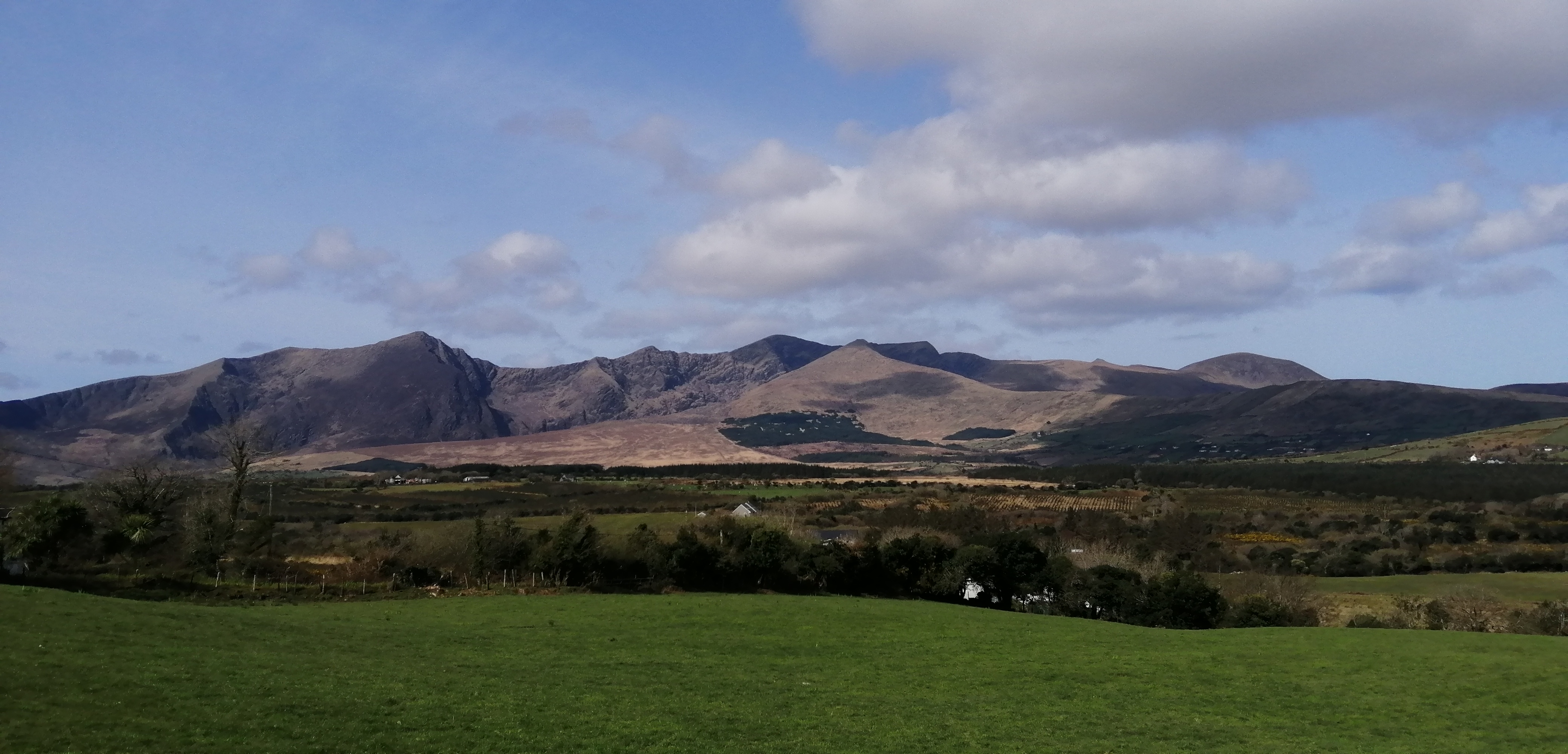
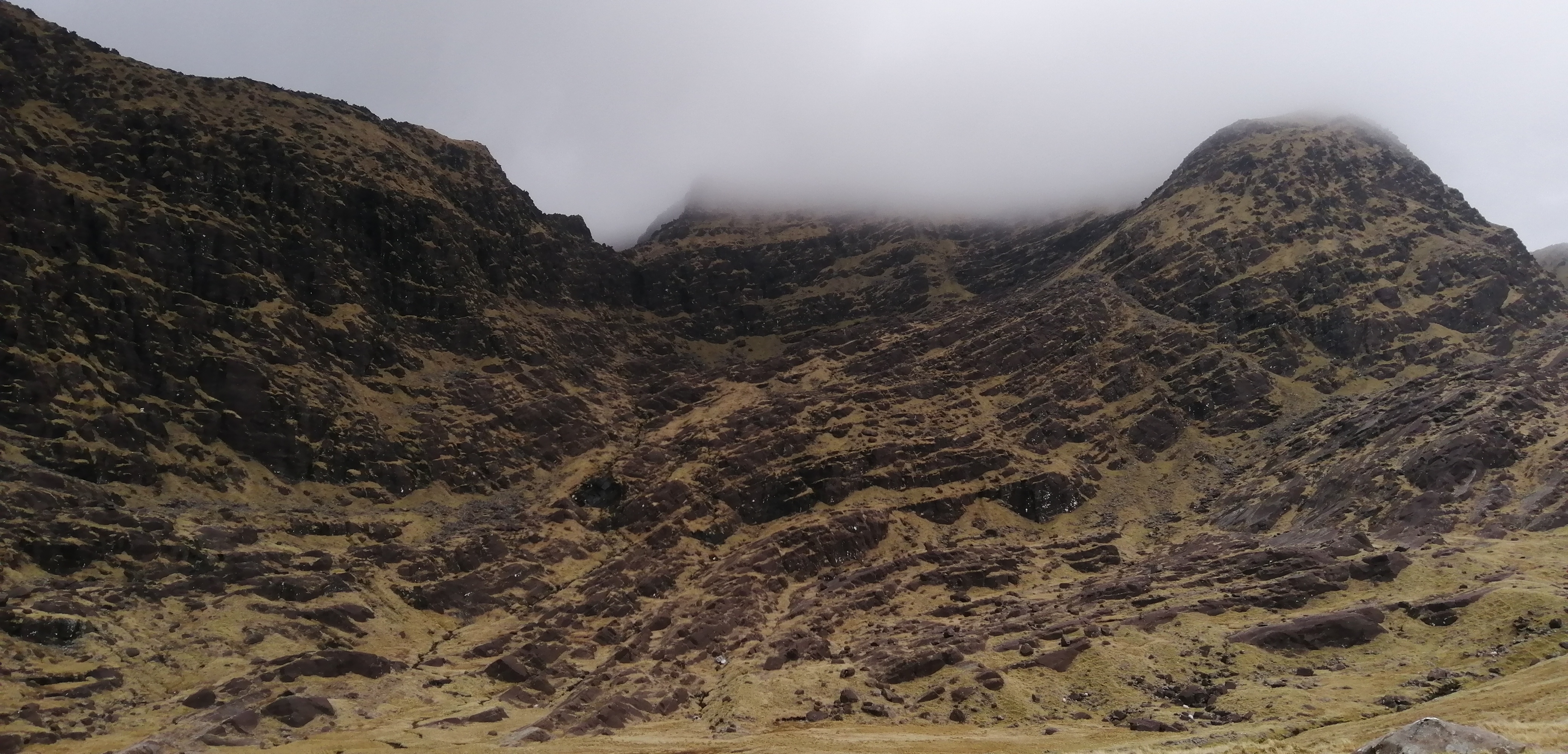
I wasn't expecting this morning to be anything other than wet and windy, so it was actually quite pleasing to find that, while the sun was hidden behind a layer of cloud, there was no rain and it was only the highest tops that were veiled in mist. I decided that I would go for a straight up and down Mount Brandon and that it would be a bonus outing for the trip. I left the car where it was and walked up from the village. The first kilometre follows the Dingle Way and is a delight as it rises from the village through grassy paddocks and alongside a stream before then joining a narrow road that rises to the car park near the grotto. The views are lovely and the elegant triangle of Brandon Peak is the star of the show. I also looked across the bay and admired the peaks I had been on yesterday. The breeze was quite stiff and it promised to be windy on top, but the bulk of the route is fairly sheltered. After the grotto the trail rises fairly gently on the flanks of the spur that rises towards Benagh and the Faha Ridge. I would have liked to do the ridge, but with the wind as it was, it would have been too dangerous. At around the 600 metre contour the trail rounds the shoulder of the mountain and heads into the back of the savage ground below the north face of Mt Brandon. This is always a spectacular place to be and as I walked in I reminisced on the time I walked in here in the fierce winter of 2010, when I needed crampons from just above the car park.


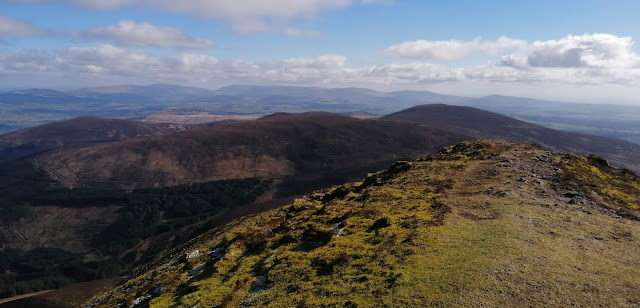
After completing the steep 150 metre climb to surmount the back wall of the coum, all that was left it the easy pull to the summit of Mt Brandon itself. I was now in the mist but fleeting breaks in the fog gave misty views towards the wonderful coastline near Ballyferriter and Slea Head. The wind was buffeting but not too bad so I decided to continue along the ridge as far as Parias Mor and descend towards Teer before crossing back over the spur of Benagh and returning to the main trail once again. It was a lovely addition to the day and allowed me to enjoy the superb views of the huge coum that rests on the north side of the ridge. Some rough ground has to be crossed to treach the crest of the ridge again but thereafter the descent is easy. Today had been a short day but it still gave me a lot of satisfaction and ended the trip nicely. 15 kilometres in 3 hours 40 mins and over 1000 metres climbed...nice


Saturday 2 April 2022

Mangerton Knocknadobar and Coomasaharn


 Last week I headed west for a few days camping, fishing, and hillwalking. Spring has well and truly sprung and the forecast promised blue skies each day. Normally I would have taken my bike as well but it was in for a service so that option was denied to me. 

Wednesday March 23rd;

I set off nice and early Wednesday morning and the weather was as promised. However, as I drove West I could see clouds still clung to the mountain tops. It was a little disappointing but I was still in good spirits as I left the car and headed for Mangerton. Low tide was about 14.00 and as I needed to dig some bait for fishing that evening I needed to be in Caherciveen by then. Since it was now just 9am I reckoned that I had time enough to include the Horses Glen in my hike. It had been a fair old while since I was last there so I was looking forward to rediscovering the area. As well as benign weather, I was also feeling really strong and I really enjoyed the walk across the rough ground before entering the Glen. Once at the shores of Lough Garagary the beauty of the entrance to the glen was revealed. Normally when I come in this way it is to avoid high winds and bad weather, so it was lovely to walk in on mostly dry ground and rock. I was simply loving being there.


Steep ground leading the Mangerton North
Looking down from the arret


The easy going ends when you reach the rocky ramp that climbs up into the inner part of the glen. Once above the ramp the glory of cliffs that form the northern face of the glen are fully revealed. It has a wild and remote feel. I turned right and faced into the near 400 metre climb to Mangerton North top. This is steep and unrelenting but it offers great views and allows height to be gained quickly. Some scrambling is also available early on if you wish. Once on the summit crest the wind was actually quite strong and definitely on the cold side of chilly but I was loving it. The cloud was doing it's best to clear and I was able to enjoy views down into the glen and away to the north the fertile lands of north Kerry stretched to the horizon. I wasted no time in heading across the arret and climbed the final pull of the day until I reached the spectacular ground of the summit plateau that rims the edge of both the Horses Glen and the bowl that holds the Devils Punchbowl.A little bit of mist still clung to the plateau but it was atmospheric and wonderful and the going was all now gently down hill. The remainder of the walk passed quickly and I was soon basking in warm sun and glorious views all the way down. I was back at the car just 3 hours 10 minutes after setting off. It had been a stunning start to the day and I was in great spirits as I headed west to Caherciveen. When I arrived there I went as far as the Kimego forest recreation area to check out what it would be like to pitch a tent there that night and I was pleased to find one spot that wasn't too rough where I could get the tent up. With that sorted I went and dug my bait and fished happily into the night.


Thursday March 24th;

The forecast for today was excellent so it was somewhat of a disappointment to emerge from the tent to a quite overcast morning. It was however dry and calm and that is acceptable any day. As I was again going to fish during the evening into darkness I had planned on doing a hillwalk once again this morning but there seemed little point if there would be no views. After breakfast I enjoyed a 40 minute walk around the Kimego Loop. At the start there is an old stone built tower that is all that remains of a peat briquette factory from the middle of the 19th century. It was something I had previously known nothing about and it was very interesting to learn about it. The walk was pleasant and passed a little time and afterwards I went to the nearby Cuascrom pier and wet a line for an hour or so. I then went into Caherciveen and got a bit of shopping before deciding to head to one of my favourite hills, Knocknadobar.

The tower from the peat factory

Disappointingly overcast but still a lovely view from the tent

The day had moved on nicely and it was just gone 1pm when I left the car. I had left the boots in the car and decided that today I would give running the pilgrim trail a go. It is a good well marked trail that is never steep and twists and turns it's way up the side of the mountain. I set a gentle pace and managed the first kilometre or so at a jog and for the rest of the way I ran when I could and walked when I had to. I didn't set any records but I was able to enjoy the experience and the views, which had thankfully started to really open up as the sun won the battle with the cloud. It was getting quite warm but I tried to drink enough water from the ladder in my running rucksack. Once on top I turned and ran the easy ground for the kilometre or so to the north top and then I turned and began the descent. I have to say that the views as you trundle down towards Coonanna harbour are simply world class. On a day like today with little breeze and now warm sunshine, a simply stunning vista is laid out before you. Blue sea, cliffs, wild hills and fairly easy ground underfoot make it a delightful descent. I took my time and trundle along and savoured the entire experience. Lower down I descended to the northern (seaward) side of the spur and returned to the road along the spectacular shoreline. It is then a simple matter of jogging back the final couple of kilometres on the pretty lane. I arrived back at the car just 1 hour 43 mins after setting off and I was delighted with my outing.

10 kilometres, 720mtrs ascent in 1hour 43 minutes.

A relaxing evening at Kells Bay followed and that night I camped near Rossbeigh beach.


Nice view while fishing at Kells Bay

Friday March 25th;

This morning the forecast lived up to its promise and I emerged into a blue sky calm day. Today I was going to do a hillwalk around Coomasaharn or the Glenbeigh Horseshoe, a hike I hadn't done in a long time and I was really looking forward to it. I wasn't pushed for time so I enjoyed a nice leisurely morning before packing up and driving the short distance to the end of the lane near Coomasaharn Lake. It was almost 10am when I was starting my hike.

What a beautiful day in a beautiful place..Starting out.

What a stunning morning it was. Not a cloud in the sky, no breeze and warm sunshine coupled with lots of birdsong made it idyllic. I set off back the lane for a couple of hundred metres until I reached a small plantation of forestry and a good track seemed to allow access to the expanse of bog beyond. Alas this didn't quite work out as I hoped and I had to do a bit of searching to find a spot where it was possible  to cross the river without getting wet feet. I should have walked back a few hundred metres more and the lane would have crossed it. Anyway, I managed it and soon I was free of any obstacles and heading up across the gently sloping bog towards Beenreagh (495mtrs) from where I could attain the main ridge. What a morning to be out. Warm sun, skylarks singing and wonderful wild landscapes all around. The final 250mtrs to reach the multi topped crest of Beenreagh is a stiff pull and certainly got the heart pumping but what a view there is to reward the effort. From the Reeks across to the hills above Sneem the array of mountains is stunningly arrayed. Nearby the splay of coums with their cliffs swing round to Drung Hill and of course the sea competes for the eye. This area is proof positive that by the Reeks area you are losing nothing in the way of wonder and majesty.


I dropped easily to the saddle under Macklaun and was now faced with nearly 400 metres of a climb. I wasn't looking forward to it but the ground is firm for the most part and I progressed nicely until before I expected it I reached the broad summit dome. Those views again gave ample excuse for a rest before I turned and headed across the wide expanse of bog towards Meenteog whose summit was 3 kilometres away. With the bulk of the climbing now behind me I relished the remainder of the outing. A series of wide, almost plateau like tops follow, whose northeastern flanks drop dramatically into a spectacular series of coums at the base of which lakes glisten. The largest and most spectacular is Coomasaharn lake, which today was as blue as the sky. Meenteog at 715 metres came first before Coomacarrea at 775 metres and finally (on my round) Teermoyle at 760 metres. I had debated with myself whether to continue my outing as far as Drung Hill but the delightful descent along the spur that bounds the western shores of Coomasaharn Lake proved too tempting so I left Drung Hill for another day. I was delighted to be treated t the sight of a Peregrine Falcon standing on a rock a mere 30 metres from me before it opened its wings and dropped into the deep. The descent went well and before I knew it I was down in the valley and near the car. It felt really warm down here and the sting on my forehead was a reminder that for the next outing I really should remember to bring sunscreen. I arrived back at the car just over 5 hours after setting off and had covered 17 kilometres and climbed over 1100 metres. 


I drove back to Rossbeigh and wasn't surprised to find it was fairly busy with people out enjoying this harbinger of summer day. The sea itself was also nearly flat calm, which isn't the best thing for a storm beach, but I determined to fish that evening anyway. I decided to relax and while away a couple of hours before commencing fishing at around 6pm. By then most of the people had left and it proved to be a beautiful evening as I watched the sun set into the sea. The fishing proved as productive as I feared but I wasn't bothered and was well happy with my day when I retired to my tent that night. When the weather is a glorious as this there are few places to beat west Kerry.


Tuesday 8 March 2022

A Quick (sort of) Round on The Knockmealdowns


A frosty night and the promise of a blue sky day saw me head towards the Knockmealdowns for one of my infrequent visits. I took my boots and trail shoes with me and decided that I would decide exactly what to do when I arrived at the car park at The Vee. 

There was a gentle but chill breeze at the car park and several groups were already getting ready to head for the hills. It was such a beautiful morning and I was really looking forward to getting out. I decided to try for a trail run so I put on my runners and left the boots in the car. I decided to run towards the Liam Lynch monument on the northern side of the range and I would decide en route how long an outing I would try for. It was such a beautiful and easy start. A gently downhill jog on the quiet road allowed me to enjoy the lovely views to the Galtees and Comeragh mountains. When I reached the point of the hairpin bend I joined the rough trail that heads down to the river in the glen below. This is at times steep and rocky so, being mindful of my fall on my last trail run on Bray Head, I took my time and was careful. When I crossed the river a nice trail headed up into the woods on the other side and on a whim I decided to take this. It rises gently until eventually you reach an exit gateway to the open hillside. Unfortunately this gate was decorated with a large sign that said no dogs and no walkers. Hmmm, what to do?. Of course I ignored it and crossed into the open ground beyond. 


Now things got tougher. A steep climb up the heather strews slopes of the ridge ahead. I was heading to Knockmoylan, an outlier of Knockmealdown itself. It was a tough 300 metres ascent as I tried to keep up a reasonable pace but it was worth it whe I topped out on the broad crest and the wonderful views opened up.The strength of the breeze also open up and it was cold and biting, so I wasted no time as I headed for the main top. I was once again able to run on the easier ground and once over this top I trundled along all the way to the summit of Knockmealdown. Progress was made a little easier as the ground was frozen solid. An easy run followed to the saddle under Sugarloaf. The 100 metre pull soon passed and I briefly stopped to enjoy the view. My mind was drawn back to the last time I was up here almost three years earlier when we were in the middle of a heatwave. Then temperatures were nearly 30 degrees and the landscape was burnt to dusty brown. The descent from here to the car is short but steep and it would be an exaggeration to say I sped down here. I hopped and shuffled but made my way safely down. It had taken just 2 hours 20 mins to cover 13 kilometres with 850 metres of ascent. Nice.