
Last week I headed west for a few days camping, fishing, and hillwalking. Spring has well and truly sprung and the forecast promised blue skies each day. Normally I would have taken my bike as well but it was in for a service so that option was denied to me.
Wednesday March 23rd;
I set off nice and early Wednesday morning and the weather was as promised. However, as I drove West I could see clouds still clung to the mountain tops. It was a little disappointing but I was still in good spirits as I left the car and headed for Mangerton. Low tide was about 14.00 and as I needed to dig some bait for fishing that evening I needed to be in Caherciveen by then. Since it was now just 9am I reckoned that I had time enough to include the Horses Glen in my hike. It had been a fair old while since I was last there so I was looking forward to rediscovering the area. As well as benign weather, I was also feeling really strong and I really enjoyed the walk across the rough ground before entering the Glen. Once at the shores of Lough Garagary the beauty of the entrance to the glen was revealed. Normally when I come in this way it is to avoid high winds and bad weather, so it was lovely to walk in on mostly dry ground and rock. I was simply loving being there.

 |
| Steep ground leading the Mangerton North |
 |
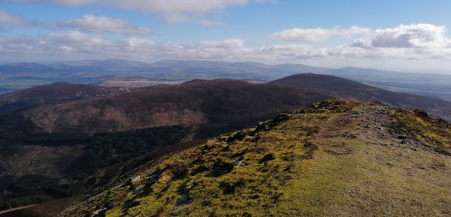
| Looking down from the arret |
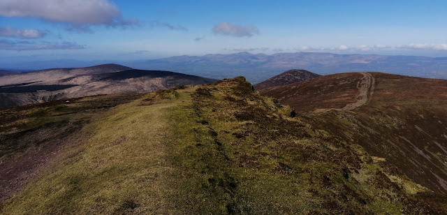
The easy going ends when you reach the rocky ramp that climbs up into the inner part of the glen. Once above the ramp the glory of cliffs that form the northern face of the glen are fully revealed. It has a wild and remote feel. I turned right and faced into the near 400 metre climb to Mangerton North top. This is steep and unrelenting but it offers great views and allows height to be gained quickly. Some scrambling is also available early on if you wish. Once on the summit crest the wind was actually quite strong and definitely on the cold side of chilly but I was loving it. The cloud was doing it's best to clear and I was able to enjoy views down into the glen and away to the north the fertile lands of north Kerry stretched to the horizon. I wasted no time in heading across the arret and climbed the final pull of the day until I reached the spectacular ground of the summit plateau that rims the edge of both the Horses Glen and the bowl that holds the Devils Punchbowl.A little bit of mist still clung to the plateau but it was atmospheric and wonderful and the going was all now gently down hill. The remainder of the walk passed quickly and I was soon basking in warm sun and glorious views all the way down. I was back at the car just 3 hours 10 minutes after setting off. It had been a stunning start to the day and I was in great spirits as I headed west to Caherciveen. When I arrived there I went as far as the Kimego forest recreation area to check out what it would be like to pitch a tent there that night and I was pleased to find one spot that wasn't too rough where I could get the tent up. With that sorted I went and dug my bait and fished happily into the night.


Thursday March 24th;
The forecast for today was excellent so it was somewhat of a disappointment to emerge from the tent to a quite overcast morning. It was however dry and calm and that is acceptable any day. As I was again going to fish during the evening into darkness I had planned on doing a hillwalk once again this morning but there seemed little point if there would be no views. After breakfast I enjoyed a 40 minute walk around the Kimego Loop. At the start there is an old stone built tower that is all that remains of a peat briquette factory from the middle of the 19th century. It was something I had previously known nothing about and it was very interesting to learn about it. The walk was pleasant and passed a little time and afterwards I went to the nearby Cuascrom pier and wet a line for an hour or so. I then went into Caherciveen and got a bit of shopping before deciding to head to one of my favourite hills, Knocknadobar.
.jpg) |
| The tower from the peat factory |
 |
| Disappointingly overcast but still a lovely view from the tent |
The day had moved on nicely and it was just gone 1pm when I left the car. I had left the boots in the car and decided that today I would give running the pilgrim trail a go. It is a good well marked trail that is never steep and twists and turns it's way up the side of the mountain. I set a gentle pace and managed the first kilometre or so at a jog and for the rest of the way I ran when I could and walked when I had to. I didn't set any records but I was able to enjoy the experience and the views, which had thankfully started to really open up as the sun won the battle with the cloud. It was getting quite warm but I tried to drink enough water from the ladder in my running rucksack. Once on top I turned and ran the easy ground for the kilometre or so to the north top and then I turned and began the descent. I have to say that the views as you trundle down towards Coonanna harbour are simply world class. On a day like today with little breeze and now warm sunshine, a simply stunning vista is laid out before you. Blue sea, cliffs, wild hills and fairly easy ground underfoot make it a delightful descent. I took my time and trundle along and savoured the entire experience. Lower down I descended to the northern (seaward) side of the spur and returned to the road along the spectacular shoreline. It is then a simple matter of jogging back the final couple of kilometres on the pretty lane. I arrived back at the car just 1 hour 43 mins after setting off and I was delighted with my outing.
10 kilometres, 720mtrs ascent in 1hour 43 minutes.
A relaxing evening at Kells Bay followed and that night I camped near Rossbeigh beach.
.jpg) |
| Nice view while fishing at Kells Bay |

This morning the forecast lived up to its promise and I emerged into a blue sky calm day. Today I was going to do a hillwalk around Coomasaharn or the Glenbeigh Horseshoe, a hike I hadn't done in a long time and I was really looking forward to it. I wasn't pushed for time so I enjoyed a nice leisurely morning before packing up and driving the short distance to the end of the lane near Coomasaharn Lake. It was almost 10am when I was starting my hike.
 |
| What a beautiful day in a beautiful place..Starting out. |
What a stunning morning it was. Not a cloud in the sky, no breeze and warm sunshine coupled with lots of birdsong made it idyllic. I set off back the lane for a couple of hundred metres until I reached a small plantation of forestry and a good track seemed to allow access to the expanse of bog beyond. Alas this didn't quite work out as I hoped and I had to do a bit of searching to find a spot where it was possible to cross the river without getting wet feet. I should have walked back a few hundred metres more and the lane would have crossed it. Anyway, I managed it and soon I was free of any obstacles and heading up across the gently sloping bog towards Beenreagh (495mtrs) from where I could attain the main ridge. What a morning to be out. Warm sun, skylarks singing and wonderful wild landscapes all around. The final 250mtrs to reach the multi topped crest of Beenreagh is a stiff pull and certainly got the heart pumping but what a view there is to reward the effort. From the Reeks across to the hills above Sneem the array of mountains is stunningly arrayed. Nearby the splay of coums with their cliffs swing round to Drung Hill and of course the sea competes for the eye. This area is proof positive that by the Reeks area you are losing nothing in the way of wonder and majesty.


I dropped easily to the saddle under Macklaun and was now faced with nearly 400 metres of a climb. I wasn't looking forward to it but the ground is firm for the most part and I progressed nicely until before I expected it I reached the broad summit dome. Those views again gave ample excuse for a rest before I turned and headed across the wide expanse of bog towards Meenteog whose summit was 3 kilometres away. With the bulk of the climbing now behind me I relished the remainder of the outing. A series of wide, almost plateau like tops follow, whose northeastern flanks drop dramatically into a spectacular series of coums at the base of which lakes glisten. The largest and most spectacular is Coomasaharn lake, which today was as blue as the sky. Meenteog at 715 metres came first before Coomacarrea at 775 metres and finally (on my round) Teermoyle at 760 metres. I had debated with myself whether to continue my outing as far as Drung Hill but the delightful descent along the spur that bounds the western shores of Coomasaharn Lake proved too tempting so I left Drung Hill for another day. I was delighted to be treated t the sight of a Peregrine Falcon standing on a rock a mere 30 metres from me before it opened its wings and dropped into the deep. The descent went well and before I knew it I was down in the valley and near the car. It felt really warm down here and the sting on my forehead was a reminder that for the next outing I really should remember to bring sunscreen. I arrived back at the car just over 5 hours after setting off and had covered 17 kilometres and climbed over 1100 metres.


I drove back to Rossbeigh and wasn't surprised to find it was fairly busy with people out enjoying this harbinger of summer day. The sea itself was also nearly flat calm, which isn't the best thing for a storm beach, but I determined to fish that evening anyway. I decided to relax and while away a couple of hours before commencing fishing at around 6pm. By then most of the people had left and it proved to be a beautiful evening as I watched the sun set into the sea. The fishing proved as productive as I feared but I wasn't bothered and was well happy with my day when I retired to my tent that night. When the weather is a glorious as this there are few places to beat west Kerry.


