Pandemic..Face-masks...Lockdown...Words a couple of years ago I would have never thought much about. Now, in the spring of 2021 they are on the tip of everyone's tongue, and included on everyone's conversation. After being in "lockdown" since the end of December last year, there was a recent easing of travel restrictions which allowed people to travel within their county. Needing to do something to break the monotony, I formulated a plan for a multi day hike.
I have often yearned to walk all the way from Claragh mountain in Millstreet, all the way to the sea at the tip of the Iveragh Peninsula. Indeed, a couple of years ago I managed most of the route, on a four day outing, when I almost reached Sneem. On several occasions, when standing on top of Caherbarna, I have looked across at Mullaghanish and observed that high, wild ground, continued away to the southwest. I reckoned that it would also be possible to link up a multi day trek, all the way to the tip of the Beara Peninsula. So now, with travel restricted to within your county, it seemed too good an opportunity to miss. So on Tuesday April 20th, Margaret dropped me back to Millstreet with my fully laden backpack and I commenced my hike.
Tuesday April 20th;
 |
A nice gentle start.
|
 |
Always a pleasure to climb Claragh
|
I was very familiar with the start of the route. I know Claragh mountain very well. It rises beside Millstreet town, and it is one of my favourite hill runs. It is also the start of a long contiguous stretch of mountain/high ground, that stretches all the way to the Atlantic ocean. Ireland had the potential to offer superb multi day wild hiking experiences that would entice the international hiker. The easiest and perhaps the most logical route would be to go over the mountains, along the Iveragh Peninsula, all the way to the coast at either Waterville or Caherciveen. My chosen route would be initially more problematical, as I was trying to forge a way through, what I suspect, would be some seldom trodden ground, before I could reach more natural hillwalking territory. I was quite excited as I started out on my journey. Old and almost forgotten feelings of anticipation and calm enveloped me as I started up the shady little lane that gives access to the mountain. It was a nice weather morning, cool and cloudy, but it promised to stay dry and the breeze was a light affair. Ideal walking conditions. The climb of Claragh is straightforward, and follows a well marked waymarked trail. I was soon struggling under the weight of the bag, and my hill fitness seemed a distant memory. That said, it felt great to be out. From the top I scanned the way ahead and looked forward to treading ground that was new to me.
 |
Looking towards the way ahead. A distant Mullaghanish with its head in the cloud
|
I continued west as far as the lane that crosses the pass and here I joined the Sli Mhuscrui. This is a route that stretches all the way as far as Kealkill near Bantry, and gives a low level alternative to some of the route I was trying to do. The route followed a forest road uphill and initially made for nice easy going. At a junction there was no marker, and of course I took the wrong option. I went downhill and reached a dead end. Rather than retrace my steps, I decided to climb steeply up through the woods and hopefully, it wouldn't bee too long before I reached the edge of the forestry. Then I could walk along the open bog towards the still distant Mullaghanish. As it happened, just before I reached the edge of the wood, I reached the correct track, and this I again followed. A lovely couple of kilometres followed as the trail crossed the open bog and headed towards the first wind farm of the trip. These behemoths were to be ever present over the first couple of days and I kinda developed a love/hate relationship with them. I was certainly glad to leave them behind on day three.
 |
A pretty impressive sight up close.
|
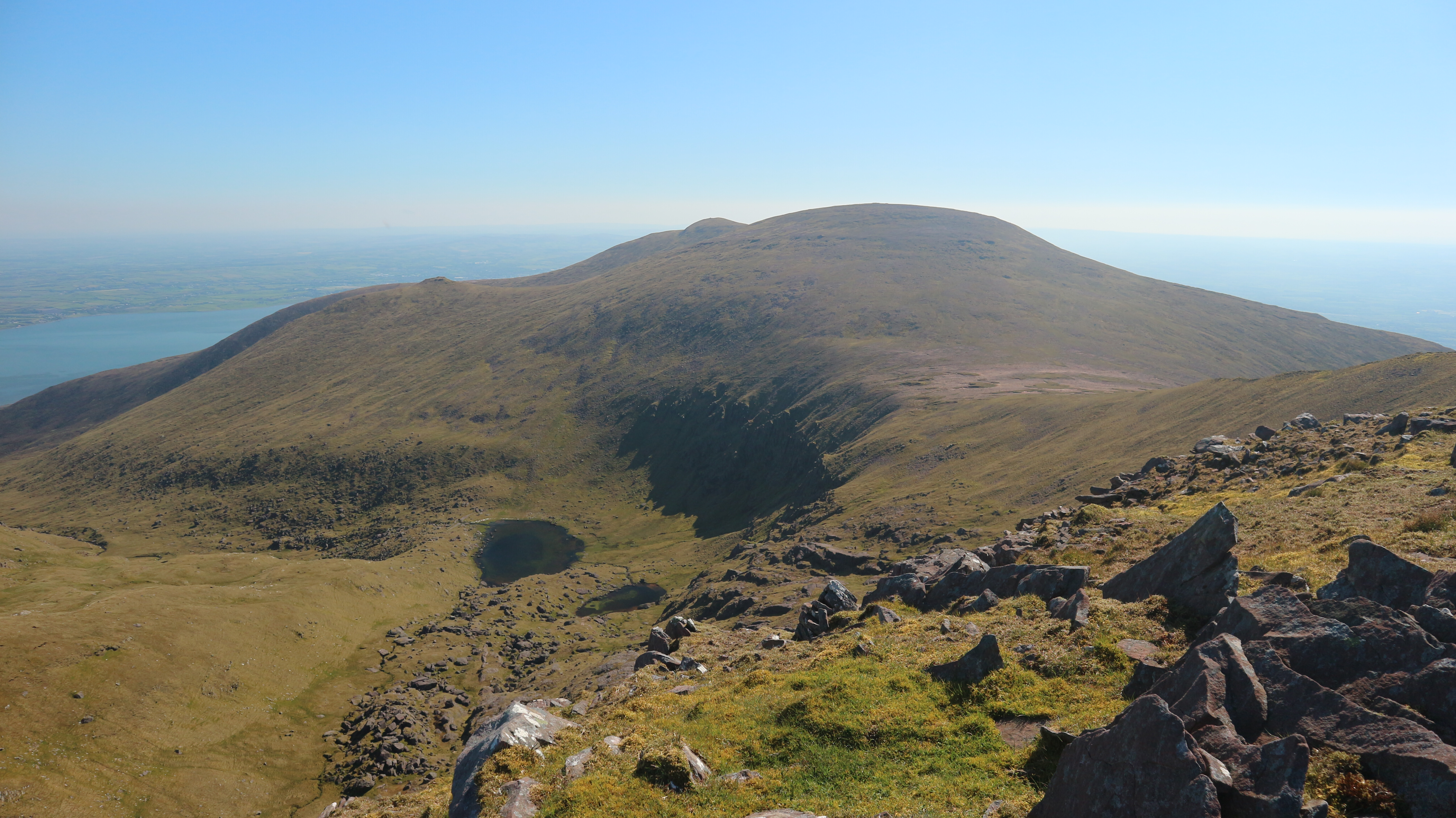
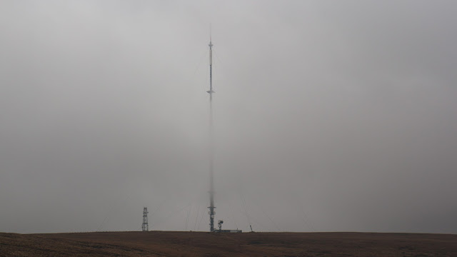
When the trail headed towards Ballyvourney I left it behind, and headed towards Mullaghanish. This proved to be a tough drag, as the ground was rough and boggy. The weather though was getting better, and the cloud was lifting off the summit. The 700 foot TV mast that spears skyward from the summit got even more spectacular as I got nearer the mountain. Eventually the slog ended and I arrived at the broad summit, with its collection of buildings and of course the mast. A strange thing occurred at the top. I had climbed to the top in a curved route. With the grey hazy cloudy conditions, it wasn't immediately clear to me which direction I should take off the hill. I had been looking to my right, and it was in my head to head that way, but it felt wrong. I paused and got the map and compass out, and to my horror, I discovered that I was looking at possibly heading towards Caherbarna, which would have been almost like heading back the way I had come. It was a salutatory lesson on how easy it is to get disorientated when on unfamiliar ground. Feeling a little chastened and sheepish I set off on the correct bearing, and very shortly it became blindingly obvious where I should be heading. I dropped down a couple of hundred metres and reached another windfarm. Now, it was an easy thing to follow another forestry road that headed in the direction I wanted to go. I reached a pair of small lakes and I briefly thought of camping near one of them.

I had been on the move for five an a half hours by then, but I could see on the map that there was another smaller lake in the woods further on, so I decided to check that out instead. The roadway continued into the woods, but when I neared the lake, it was very obvious that the ground around it was far too rough to camp on, so I kept going. I now had to find a way out of the woods, so as to reach open ground, so I could stay on route. I found a firebreak in the woods and followed that, and thankfully I was soon clear of the trees. The ground however was horrible, and even when in the clear, I had another kilometre of wet awkward ground to climb to reach the top of Knockacommeen. I had now covered over 25 kilometres, and was really looking forward to finding somewhere to camp. I was nearing the main Cork to Killarney road. As the ground beyond was also covered in forestry I hoped to be sorted before I reached it. Shortly after leaving the top I saw a gently ridge, with green grassy patches, and the beginnings of a gully alongside it. I was really hopeful that I would find a water source near there. Alas it was not to be. The recent dry weather meant the gully was dry, and water didn't appear until I was down almost to the road. I filled my water bottles here and headed for the woods on the other side. I determined to pitch my tent at the first opportunity. I found a rather damp, but flat area, a kilometre beyond the road. My oh my, but it was a relief to drop the bag. I wasted no time in setting up my home for the night and cooking dinner. My unpracticed body need rest.
It had been a long day. 28 kilometres..1000mtrs of ascent in just shy of 8 hours.
https://www.wikiloc.com/hiking-trails/millstreet-to-castletownbere-hike-day-1-72365319
 |
I've stayed in prettier spots but it was welcome to find it.
|
Wednesday April 21th;
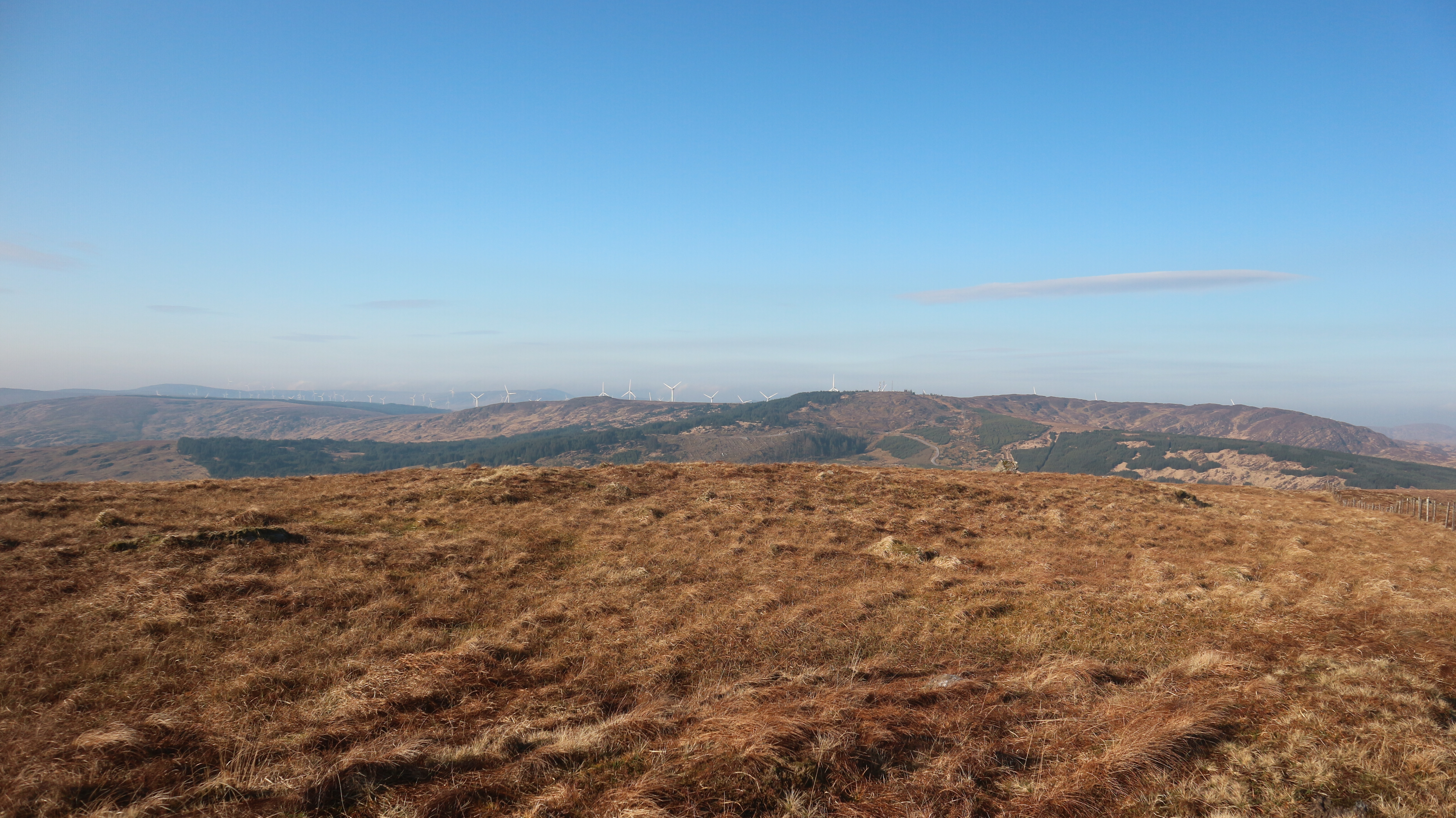
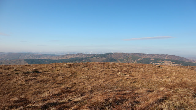
I wish I could say that I was fully recovered this morning, but I couldn't. Having said that, I wasn't too bad. It was a lovely morning. Clear skies to the east, allowed a warming sun bathe the tent, and the misty cloud that clung to the hills, promised to burn off. It was an easy start to the day, but I had the problem of how to exit the woods ahead of me. I went along the forestry road until I reached a steep windbreak that seemed to head for the wood's edge. I struggled up this, which brought me to another windbreak, and this thankfully did reach open bog. Once there, I climbed to the broad top of Knockbwee 461mtrs. It felt really good to reach here, and I could now better see the route ahead. I could see the high ground that stretched to Gougane Barra. I was also heading directly towards a series of windfarms. I used the roads of the first one to navigate my way towards more open ground, and then I was able to drop to, and cross, another quiet road beside, what claims to be, Ireland's highest pub. Beyond this there was a farm track that led most of the way to the crest of the next hill, and from here, it was open ground all the way to Gougane Barra. I had reached the Mweelin Ridge, which undulated it's way southwest. Another wind farm dominated the landscape all the way along the right hand side. Indeed when I paused to give them a quick count, I could see a total of 98 turbines from my vantage point.
 |
A beautiful morning..but how to get out of thew woods?
|
 |
Great views looking towards Crohane and Mangerton
|
 |
The way ahead..into the turbines
|
 |
Leaving Mullaghanish well behind.
|
I was starting to suffer again. Each hill I came to was a challenge for the legs. I was able to keep plodding, but I was slow. By the time I reached Coomataggart, before Gougane Barra, I was contemplating stopping for the day. I had been on the go for 5 hours by then, and covered 18 kilometres, but it was only lunchtime, so I continued on. I crossed the wild, sometimes rugged ground that curves around the hidden from view Gougane Barra. I had originally thought I might get as far as Knockboy, but that was still a fair way off and I was frankly too tired to contemplate going that far. I reached the ridge that dropped to the pass before Knockboy and shortly afterwards I spied a superb place to camp. I headed for it without hesitation. Oh my lord what a relief to drop the bag. My sore shoulders seemed to expand involuntarily and I just sat and relaxed awhile before I did anything else. It was 15.30 and I had been on the go for almost 8 hours. Knockboy could wait til tomorrow. Next up was a brew, and then the tent. I had gotten my first proper sunburn of the year, and my forehead promised to be quite sore later. Once the tent was up, I retreated into it, and just crashed for over an hour. Once I felt a little recovered, I whiled away the evening by reading, eating and enjoying my lovely surroundings. I could see the silver reflection of the innermost reaches of Bantry Bay at the end of the valley, and I now knew that the glories of the Beara Peninsula stretched ahead. I was enthused and looking forward to the days ahead.
 |
Just some of the turbines.
|
 |
Approaching Gougane Barra
|
 |
Campsite No2
|
 |
A beautiful evening
|
24 kilometres..1000mtrs ascent...7 hours 50 mins.
https://www.wikiloc.com/hiking-trails/millstreet-to-castletownbere-hike-day-2-72365921
Thursday April 22nd;
 |
Leaving camp.
|
I had slept very well, and as I lay, snug in my sleeping bag, I felt quite relaxed and rested. After a little while I opened the door of the tent and had a peek outside. It was a calm morning and I was completely enveloped in mist. As it was so calm, I decided that the mist was probably fog, and that there was a chance that, as I climbed Knockboy, I might enjoy a temperature inversion. It only made me look forward to the day more. When I was all packed up, I took out the map and compass and took a bearing for the road and the pass. I reached the narrow road well before the pass, and I enjoyed a nice easy walk until I reached the highest point on the road. My hopes of a temperature inversion were dashed, as I discovered that I had been in cloud rather than fog when I emerged below it at the road. On the plus side, there were already some breaks in the cloud, and it seemed to be rising quite quickly, so I was hopeful that I would get views during the day. When I said that I was well rested this morning, well, I guess it is all relative. The steep initial climb from the gap was tough on the legs, but to be fair, I wasn't doing too badly. The gradient eased back a little and a lengthy slog followed, across rough ground, as I headed for Caoinkeen 692mtrs. The cloud lifted above the summits and I looked forward to great views for the remainder of the day. As I got higher, the cold wind strengthened, so by the time I reached the broad summit, I was being buffeted. I turned and crossed the wide expanse of bog that lay between me and Knockboy. This was on fairly easy ground, and allowed me some respite, before the steep pull to the top of the highest mountain in county Cork at 706mtrs.
 |
Approaching Caoinkeen
|
 |
Easy ground towards Knockboy
|
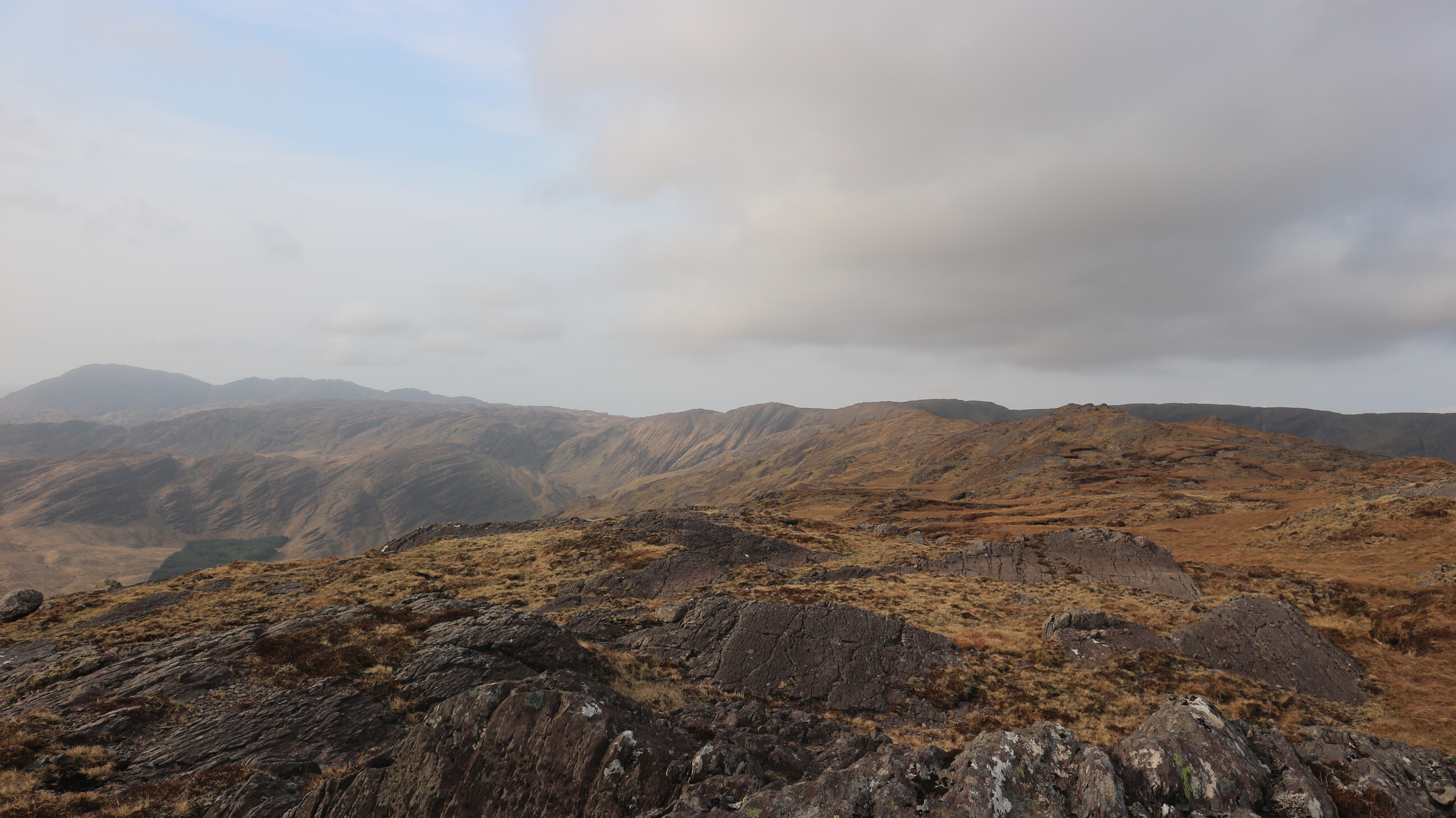
It was hard to believe that this would be the highest point I would stand on on this trip, but what lay ahead, was undoubtedly wild. So far I had crossed three roads. Two of them were small little quiet lanes over passes, and the other a busy national route. Over the remainder of the trip I would cross three more, and these would offer good benchmarks of my progress. First up came "the priests leap", a steep narrow road that offers one of the toughest cycles in Ireland. This was just a few kilometres from Knockboy, and as it was mostly downhill, I soon reached it. This was a pleasant place to reach and I speculated about trying to cycle it later in the year...maybe. Onwards and upwards towards the next top. It was really a lovely day to be out on the mountains. The breeze was to my back, the ground was relatively dry and the views were wonderful. I was now in the middle of my third day and I had seen precisely no one, it was fabulous. I decided to head as far as the Caha Pass and try to find somewhere to camp near there. I had initially thought to go as far as the high ground several kilometres beyond the pass, but it was clear that it would be too windswept to camp up there. Over the next 9 kilometres there ensued a series of climbs and drops. Some of the drops crossed wild rough ground, but nothing too long or taxing. Each drop brought me slightly lower, until eventually I reached the pass which is just over 300 metres.As I neared here I was on the lookout for somewhere to set up my home for the night. I contemplated dropping all the way down to the woods near Glengarriff, but opted to try and stay high in the hills if I could. Crossing the pass is a slightly surreal affair as, you don't actually cross the road, but rather stay on the ridge as it crosses over the tunnel at the pass. It is actually quite a nice feeling and the road doesn't encroach on the hike at all. A steep 100 metre climb saw me reach the crest of the ridge on the far side, and from there I could see into the large coum ahead and below.I decided to head for it and hope to find a water source and flat spot to camp. I had to drop slightly lower than I would have liked but eventually, down at around 270mtrs I reached very nice ground, and I had my home for the night. My solitude and peace was only broken by the calling of lambs on the slopes nearby.
 |
The priests leap road...looks easy?
|
 |
Glengarriff comes into view
|
 |
Nearing the Caha pass
|
 |
Home for night 3
|
It had been a worthy effort...24 kilometres...1500mtrs ascent..1700mtrs descent in 7 hours 45mins.
https://www.wikiloc.com/hiking-trails/millstreet-to-castletownbere-hike-day-3-72367477
Friday April 23rd;
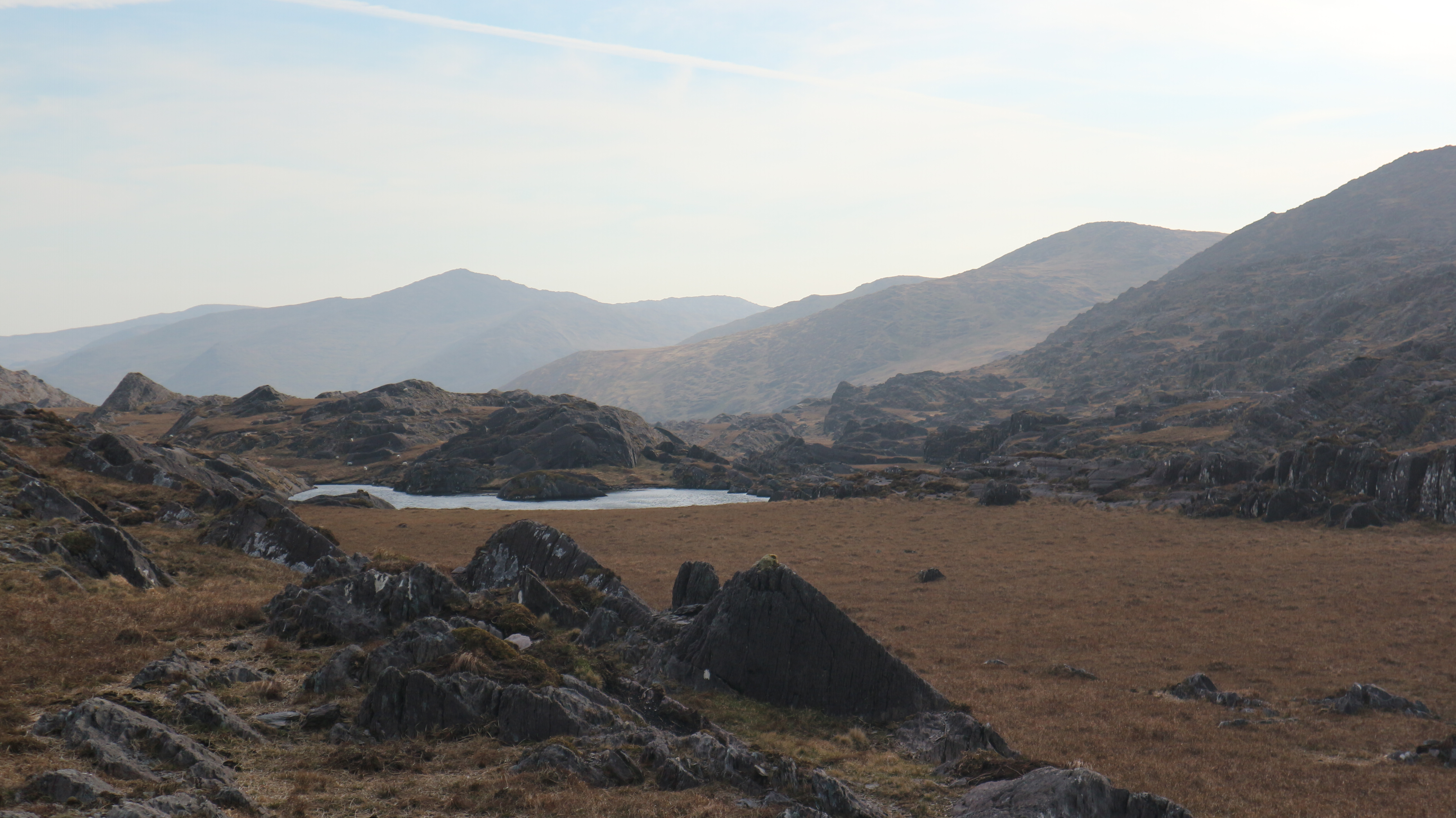
I had thought/hoped that the wind would have died down overnight but it seemed to have increased in strength by the time I reached the ridge line again. It was however, bright and sunny and promised to remain so for the day. The 250 metre pull to reach the ridge certainly got the heart pumping, but what made my heart soar, was the sight of a pair of sea eagles gliding effortlessly, just above me. This was the best view I have had of these magnificent birds in years. They hovered directly above me, and rode the wind. They seemed keen to take a good long look at me. I stood and stared enraptured for the precious time they remained near. It was a magnificent start to the day. When I resumed my journey, I followed the pleasant ridge, until I climbed to the higher ground at the end of the long remote valley. When I reached this high, wild place, I was very glad I had decided to forgo camping here. The wind was quite strong and even on a clear sunny day, it had a wild remote feel to it. I must confess to having been surprised by the scale of the area. I have chosen to think of it as the "Caha Wilderness". It is easy to now understand why sea eagles have picked this area, as one of the few places in the country, to breed. The boggy expanse holds several small lakes, and when the cloud lies low, I imagine the area would offer some good navigational challenges. Today, it was easy to simply follow the slightly higher ground, over Rams Hill, until I reached a rugged high pass, in which nestled the beautiful Lough Shanoge. A stiff 150 metre climb follows, and then an undulating curving section, of typical Beara ground ensues, as you head for Knockowen 658mtrs.
 |
The Caha Wilderness
|


This section offers a great example of the difficulties you experience when hiking on the Beara Peninsula. The ground is mostly crossed with rock strata, that almost constantly makes you chicane around ridges of rock, and offers many mini climbs, of anything from a couple of metres to ten metres. This ground isn't represented on the maps, but it adds up to a lot of extra ascent in the course of the day. From Knockowen, I now had my sights set on the next road pass of the trip, the Healy Pass. Another road that offers one of the best cycles in the country, which I have "enjoyed" several times. It was a straightforward, three kilometre descent to the pass. Here, I saw my first people of the trip. It was still quite early when I arrived, so I simply crossed the narrow road and headed steeply up the far side, and headed for the wonderful Hungry Hill. The scenery all around is simply wonderful. The Beara Peninsula is truly one of the most beautiful areas in the country, and is without doubt, one of my favourite places to visit. I was emotionally torn as well. I knew I was nearing the end of this trek, and I was really pleased that it had gone so well. On the other hand, it was because it had gone so well, that I was sad that it was going to end. Because of the pandemic, the cable car to Dursey Island was closed. This was a real shame, as being able to go to Dursey Island would have added a couple of extra days to the journey. When I reached the final col before Hungry Hill, I was again getting tired. I wasn't really looking forward to the 250mtr climb to the summit. It went surprisingly well however, and once on the broad top I knew that all the climbing was done for the day. The wind up here was really strong, so I knew I would have to go lower to find somewhere to camp. From the top I turned due west and descended the steep ground towards the valley far below. Bands of steep rock criss-crossed the face of the hill and made it necessary to zig-zag a bit on the way down. Interspersed with the rock, were some level grassy sections, which on a calmer day, would offer great places to camp. Once I had dropped a couple of hundred metres, I became hopeful that I would find someplace out of the wind, that would offer sanctuary for the night. Finally, down at around the 300 metre contour, I came across a likely spot and headed for it. I dropped my bag in the warm sunshine and enjoyed the excellent views, out of the wind. Home. A very pleasant few hours passed and I chilled and fed myself in splendid solitude. Alas, for some reason, as the evening closed in, the wind managed to find my campsite and it buffeted the tent right through the night. I guess nothing is ever perfect.

 |
Nearing the Healy Pass
|
 |
Approaching Hungry Hill
|
 |
Home for night 4
|
Another substantial day...21 kilometres...1850mtrs ascent...7 hours 10 mins.
https://www.wikiloc.com/hiking-trails/millstreet-to-castletownbere-day-4-72430521
Saturday April 24th;
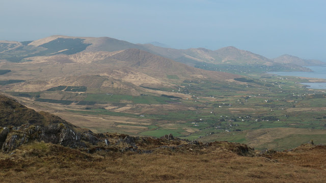
Considering that I slept very little overnight, I felt surprisingly rested when I extricated myself from my warm sleeping bag this morning. It was still breezy, but the skies were clear, and once again it promised to stay dry for the day. It is very seldom that I have gone for a substantial hike and not needed to use my rain gear at any stage. Anyway, after breakfast I headed down to the low ground, where I could join the Beara way for a little while. The descent went well, with only a few rocky sections that were easily avoided. Soon I was down by the rather anemic river (the dry spell had taken it's toll) and I set off along the way. I had intended on following this until it crested the ridge ahead, and then following a bog road to the base of Knocknagree, but I found myself heading up slightly steeper ground, and I decided to continue in this way until I reached the wild ground, well before the final climb of Knocknagree. Once I reached the ridge, the wind was again quite strong, but this didn't detract from the wonderful views. The glory of the Iveragh Peninsula lay along the northern skyline. To the south the beautiful Sheeps Head peninsula lay across Bantry Bay and of course, you are in the heart of the Beara. It was sublime.
 |
Before Knocknagree
|
 |
Looking towards Allihies...future promise
|
 |
Journeys end.
|
The final 150mtr climb to the rugged top passed quickly enough. I even enjoyed some scrambling by opting to climb some of the buttresses that are en route. With the wind being so strong, I didn't hang around too long on top before I headed to the boggy pass below Maulin. When I reached the pass I decided to include the north top in my trip. This only added a few extra metres to the climbing and not much more than a kilometre in distance. Finally I stood on the broad top of Maulin 621mtrs, and from here it was all downhill to the still distant Castletownbere. I could have gone down due south and rejoined the Beara Way that way, but I decided to follow the southwest ridge and join the way a little further on. If I was going to continue towards Allihies, then this would have been the route to take. As I went down I was constantly scanning the land beyond and trying to pick a possible future route. Eventually, I arrived at the flatter ground, and I began the final seven kilometres to the town. Wow, the difference in temperature down here was huge. On the tops, it was necessary to have hat coat and gloves on all the time. Now it was baselayer and sleeves rolled up for the remainder of the way. Eventually the open bog gave way to shady, country lanes, and these too had their charm. I arrived into the busy fishing port at 12.15, in loads of time to catch my bus back to Cork city where I could get a train home.

It had been a relatively easy outing today..Just 15 kilometres covered...800 metres ascent...4 hours 45 mins.
https://www.wikiloc.com/hiking-trails/millstreet-to-castletownbere-day-5-72430730

I enjoyed a delicious roll and a couple of coffees and basked in the very pleasant warm sun. When the appointed time for the bus to arrive came, and passed, I found myself half hoping that it wouldn't arrive at all. I could return along the way and resume my journey to Allihies. I didn't get to dream for long however, as after a couple of minutes the bus arrived and I set off for home. The journey passed well, and the views, as we neared Adrigole, of the savage east face of Hungry Hill, were simply world class. I reminisced on the trip and basked in the glow of a hike well done. There is no doubt that I suffered at times, but I got stronger as the days passed, and of course I was really fortunate with the weather. Over the five days, I covered a total of 112 kilometres and climbed a total of 6200 metres. It felt like it had been as good a hike I had done anywhere. I am enthused about the rest of the year. Here's hoping there are more good trips like this too come.