
Friday October 19th;
Today was all about getting there. A very early flight from Cork to Amsterdam was followed (after a three hour stopover) by another flight to Toulouse. A 40 minute delay in Schiphol meant that I missed my hoped for connection to Luchon. I caught the 15.40 train out of the city but two bus connections followed (due to the railway line being closed for upgrade works) which all meant that it was 19.00 before I alighted in Luchon. It being so late I headed for the nearest campsite (Pradalongue) where I had stayed before only to find that it was closed so I had to walk the couple of kilometres to the other side of the town to reach the next nearest one which, thankfully was open. It had started to rain as I walked and it was a case of pitching in the dark and the wet and I was mightily relieved to enter my tent at 20.00 hours. It had been a long day.
Saturday October 20th;
 |
| Luchon |
Today I would begin my hike. It didn't get bright until 8am and it was a misty cloudy morning I emerged to. I packed up my wet tent and I left the campsite at 08.45. The first order of business was to get some gas for my stove so I went into town to Mr Mountain outdoor store and after waiting for them to open at 09.30 I stocked up and started my climb. Finding the Gr10 in the town can be a bit problematic and the woman in the outdoor store said that following the No2 trail from the little lake by the baths would offer easier access and I would join the Gr higher up.
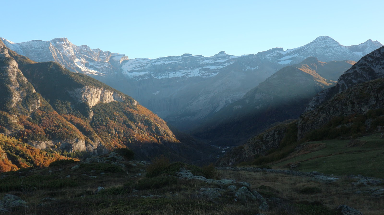
It was raining once again as I left the town but I didn't mind as it was a joy to be finally underway. Besides I was immediately engulfed by delightful woodland which was both atmospheric and enchanting. Luchon lies at just over 600 metres and the ski station at at Superbagneres is at over 1800 metres so my first climb of the trip wasn't insubstantial. Add to this the fact that today my bag was at its heaviest (I carried almost 5 days of food) and it's fair to say that I wasn't gliding up the hill. That said I wasn't doing too badly either and I kept up a steady pace. It is also fair to say that I don't have the best history when it comes to following the trail and right from the start I stayed true to form when I failed to connect with the Gr10. I stayed on the No2 trail until I also lost that. Then just kept on taking whatever trail I came to that was heading up. Eventually I ended up just climbing directly up through the trees and suddenly, lo and behold there was the Gr10. I followed this for the next while and suddenly the ski station loomed out of the mist. I was a bit surprised as it wasn't yet midday, which meant I'd taken just over two hours to make the climb.

 |
| Walking in the woods in the rain...nice |
 |
| A superb viaduct I stumbled across. Arches on top of arches. |
Having been here before on the final day of my previous trip and with nothing like a view to distract me I set off immediately on the next section that led towards Lac d'Oo. When I had been here previously I had thought that almost all the climbing had been done for the day, I wasn't under any illusions today. There follows a nice easy few kilometres where you traverse the hillside until eventually you begin the climb up Col de la Coume de Bourg which at 2272 metres meant another 500mtrs of ascent is added to the day. On the plus side the rain had stopped and there was the odd break in the mist which gave fleeting views down towards the valley below. Eventually I reached the Col where I enjoyed a rest and some food. Wow, nearly 1800 metres of climbing done and a little more to come. There's nothing like an easy first day to break you in gently 😯. Next you traverse two wild coums that, in decent weather, make for a spectacular passage. After dropping down from the Col you have a gradual pull up to the narrow crest before another traverse and climb sees you reach the final pass over Hournette des Hounts-Secs at 2267 metres. The 2000 metres of climbing had taken their toll and sore feet, aching shoulders and chafing undergarments meant I was looking forward to reaching journeys end today.
 |
| Finally things start to clear. Lac d'Oo and its spectacular waterfall...one of the best in France |
 |
| Refuge closed |
 |
| Down towards the Gite |
A 400 metre descent sees you almost reach Col'Espingo before I finally set foot on tracks new and headed towards Refuge du Lac d'Oo. This was pretty straightforward and I was even treated to some views as the weather continued to improve. The lake and spectacular waterfall appeared and the surrounding peaks unveiled themselves. It was ample distraction from my growing fatigue and discomfort. I reached the lake outlet and it was clear that the nearby refuge was closed. I briefly toyed with the idea of pitching my tent near it but I decided to grind it out for another while and head for the comfort of the Gite at Les Granges d'Astau a few kilometres further on and 400 metres lower. The track was fairly busy and I met plenty coming up against me as I went down. Eventually I reached the large parking area but I was very disappointed to find that the Gite was closed. It was now after 5pm and getting chilly and I was aware that my tent was wet. I was resigned to using it but first I had to find somewhere to pitch it. I walked down the road a little and I saw a sign for camping 400 metres ahead..result 😀. I passed an elderly man doing a bit of work with a shovel and on a whim I asked him about the campsite. He told me it was closed and I guess he took pity on me and said I could pitch my tent by his barn near his house. I was delighted and relieved and it was almost ten to six when I finally dropped my bag. I wasted no time in setting up the tent and getting dinner on the go. After a wipe down the tent dried up okay and before too long I was all set for the evening. Darkness wasn't too long in coming and I just decided to doze and sleep the time away. The skies had cleared up nicely and things got quite chilly but I was nice and snug in my down sleeping bag. After nearly nine hours on the go, covering 24 kilometes and climbing over 2000 metres it was time for rest and recovery. It had been a full day.


 |
| Home sweet home |
Sunday October 21st;
I emerged into a chilly cloudless morning and blessedly felt quite recovered. My toes were somewhat the worse for wear and my little first aid kit was produced and plasters applied. I was on the move again by 9am and I was delighted to find I was feeling strong and moving well. The trail was literally a few metres from the tent and it rose steadily up across the pasture until I once again entered the woods. At around the 1700 metre mark I left the trees behind and entered a long valley that rose gently towards the first pass of the day at Couret d'Esquierry which at 2131 metres would add another 1000 metres to the trips climbing. Once I cleared the treeline I was bathed in warm sunshine and it was lovely to bask and enjoy the views. Behind and to the south peaks soared and there were significant amounts of snow on north facing slopes down to 2500 metres. Where I was though, felt more like being transported back in time a couple of months as the strength of the sun was quite strong. The pass came and I was treated to vistas new and I set off down towards the village of Loudenvielle. The path was gradual and the weather great and despite yesterday's trials I was feeling good and enjoying myself immensely. First up came the rather unfortunately named, sleepy village of Germ which was at 1339 metres. Loudenvielle looked so close but it still lay over 350 lower and was another hours walk away.
 |
| Starting day two |
 |
| Not bad views either |
 |
| Up in the sun heading for Couret de Esquierry |

 |
| Towards Loudenvielle |
 |
| What a morning..what a trail |
After Germ I sat in a sunny meadow for lunch before finally entering the village below. From above it didn't look too interesting so it was a nice surprise to discover it was a charming collection of old, well preserved and presented buildings that on another day I would happily stayed more time exploring. However I had more climbing to do and a fair way to go to reach Saint Lary Soulan. Over the years I have come to realise that the time planned and the time actually required are seldom the same on the Gr10. A steep path cut up through the woods as I headed for Col d'Azet at 1580 metres. There were lots of parapunters in the skies and I even spotted a couple of eagles. Slow but steady did the trick and I crested the ridge and once again was greeted by new vistas. I watched a few people take off from the nearby hilltop before again resuming my journey. A nice easy traverse of the slopes followed that was very enjoyable before dropping into the village of Azet. Not too far to go from here which was just as well as my feet were sore and fatigue was becoming more evident. I reached the road in the valley and after a quick look at the map I realised that I had just passed a campsite 50 metres before. I retraced my steps but I was to be disappointed as it was closed. There was another one about 600 metres away so I headed for there. Again it was closed. I returned to the first one where I had found a working tap and decided to pitch my tent there. It was almost 17.30 and the sun was quickly departing over the mountain crest but at least I had a home for the night. I wasn't long settled when a woman approached and informed me that the site was closed. I pleaded that everything was closed and that I would be gone in the morning so she allowed me to stay. Man it really was out of season.
Today, another 24 kilometres covered in almost 8.5 hours and 1600 metres of ascent.
 |
| In Germ |
 |
| Still an hour away |

 |
| Its not all about the big mountains..utterly delightful |

 |
| Amazing Autumn colours in the landscape |

Monday October 22nd;
It was decidedly chilly this morning but once again the skies were clear and the weather forecast promised it was to remain so for several more days. What I wouldn't have given for a nice shower but instead I made my way to the nearby supermarket for some fresh bread and cheese. The shop was so cosy and warm inside I could easily have lingered. Back to the tent for a warming breakfast and I was once again on the move by 9am. I now had two days to cover before I reached the next town and today I planned on taking the first good opportunity to camp that came along, once I had covered almost reasonable distance of course 😊. First up came the 800 metre climb to reach the long lumbering broadback that led towards Col de Portet which at 2215 metres would be the high point of today's outing. Despite the exertions of the previous few days I was feeling good once I was on the move. My toes were settling into the routine and while still a bit raw things were feeling a bit better. Thankfully my body is still strong and I actually preform best on the uphill sections. Another little charming village nestled at the base of the slopes (Vielle Aure) and then began the ascent.

 |
| The bonfire created a surprisingly large layer of smoke off to the left |
It was the kind of track I liked. Steep enough to gain height quickly but not so bad as to require frequent rests. A pair of eagles passed overhead not too far above the canopy, spectacular 😊. Across the valley another ski resort (le Pla d'Adet) let's just say didn't nestle on the hillside and I was struck by the scale of the Ski industry. I guess I must give it a try sometime. Thankfully things were much more pastoral where I was and soon I was climbing up through herds of grazing cattle and I could see my trail rising gently towards le Serre, a big old whaleback at 2017 metres. It looked so close but perspective is skewed in these big hills and even though I tried to be conservative it still took longer than I expected to reach it. Not that I was racing mind, I was enjoying a totally relaxed morning. By now I had climbed over 1200 metres and the bulk of the ascent was done for today. Next up came a nice easy few kilometres until the final pull to the Col. I reached there at lunchtime and enjoyed a rest and a bite to eat. Not that it is the most pleasant of passes I have been on. Again, ski paraphernalia dominated but the views across the deep valley ahead towards a wonderful collection of 3000 metre plus mountains meant the eye had elsewhere the rest.


Prior to starting my trip one of these peaks, Pic Long 3192mtrs, was one of the possible peaks I wanted to climb. While I was still tempted I was now coming to the realisation that the Gr10 offered challenges enough for me on this trip and the two day diversion from the route would be too much. Instead I followed the trail as it traversed almost horizontally under Montarrouyes 2481mtrs. Eventually a junction arrived and the trail started to drop down towards Lac de l'Oule. I had thought I would perhaps stay at the refuge at its southern end of the lake but when I finally reached the pastoral hut at Lude on the northern end a campsite of such perfection presented itself that I immediately decided to call a halt for the day. It was just 15.30, warm and sunny so I should have the benefit of the sun for another couple of hours. I quickly set up the tent and I even enjoyed a brief body wash in the nearby stream. My feet were soaked (for as long as I could bear it) in the chilly water and then I set about the serious business of relaxing and soaking up the sun. There was even a well used fire pit alongside and even though I generally frown on campfires (I think they are normally an unnecessary blot on the landscape) I gathered up some dead wood from the nearby forest and I enjoyed a warming glow in the twilight hours. It was a pretty idyllic evening and just what I had hoped for.
So, 16 kilometres covered..1400 metres climbed in just about seven hours.


 |
| Lac de l'Oule |
 |
| Camping heaven |

 |
| Happy noodle |
 |
| Like a scene from "The Fog" it undulated and crept its way up the lake at dusk |
Tuesday October 23rd;
One on the things about camping at almost 6000ft at the end of October is that it tends to get a little chilly during the long nights and the coating of ice on the tent this morning confirmed that. Still I had slept well. In the chill I breakfasted and packed up and I was delighted to find the effects of the wash and soaking of the feet was entirely positive and I felt restored. A lovely walk around the western side of the lake saw me reach the start of the days first climb. Nothing too taxing, 450 metres to reach Col d,Estoudou. As this is in a national park there was none of the ski industry on show and when I reached this wonderful spot I rested awhile and revelled in my surroundings. This was more like it. The views towards Pic Long etc was uninterrupted and stunning and a feast of alpine scenery. Now I was closer they looked both intimidating and inviting. I was again tempted to abandon the trail for a couple of days but I eventually stuck with the programme. A nice traverse through the woods ensued before I reached Lac d'Aumar. The wildness of the area was compromised somewhat by the fact that it can be reached by road and there were quite a few people about. I guess I was being a little selfish and just wanted it all to myself.
 |
| Leave no trace |
 |
| Rather special views towards Pic Long and others |

 |
| More happy noodle |


Next up came the 300 metre climb to today's high point, the wild and spectacular Col de Madamete at 2509 metres. This rose initially on a good path but higher up near a small deep lake, boulder fields had to be crossed before the final slopes to the pass. Reaching here was great and a rest and bite to eat went down a treat. The views were superb, especially towards Pic Long and from here the true extent of the snow on the upper reaches could be seen and I was glad to have decided to stick to the trail. The famous Pic Du Midi De Biggore with its observatory and hotel could be seen. This was another possible peak I had in mind but again it would have required a two day diversion and with the probability that all accommodation was closed I discounted the idea.


 |
| The full extent of the snow cover up high revealed. Beautiful tho |
 |
| Down from the pass |


So next up was the long descent to Bageres where there was a campsite and I hoped a shop. Easily down through wild ground initially that gradually turns more pastoral until you reach a basic refuge at Aygues Clunes. From here the trail enters the narrow valley and heads west before turning to the north and eventually reaching the road that leads to Col Du Tourmalet. It had taken me nearly seven hours to reach here and I was pleased to see a sign indicating Bareges was just 40 minutes away. I had just started heading down the road when a car stopped and offered me a lift. It was initially reluctant but sense prevailed and I took the lift. The woman asked where I was going but when I told her she informed me that everything was closed and that I would be better off going down to Luz St Sauveur if I needed to find somewhere. I agreed and enjoyed the drive down the long deep valley. She dropped me at the tourist office and I went in search of a bed for the night.
Anyway long story short,I discovered that all hotels and gites were closed and it was a huge relief the find one campsite open. The small site was back up the road a half kilometre but it had fine showers, a fine warm games room where I could sit and read and all for the ridiculously cheap price of just over a fiver. I made full use of all the facilities 😊😊.
Seven hours, 18 kilometres and 850 metres up--1200 down (plus the wandering around Luz)
Wednesday October 24th;
I really can't get my head around the fact that practically everything tourist related was closed because it was out of season. Can you imagine going to Ambleside in Cumbria or Clifden in Connemara and discovering that all the hotels and B&Bs were shut for a couple of months??. Here though, that is the case and if you are going to head to this neck of the woods it would be wise to keep it in mind. Anyway, one of the things I learned while at the campsite was that the weather was due to change at the weekend with a big drop in temperatures and snow down to low levels. That left me with two or possibly three days of good weather left and I was determined not to waste them.
Okay, rant over and back to the hike.
 |
| Leaving Luz |
 |
| Saint Saveur |

I found the trail with the help of a local man and followed it out past a little chapel and then to the impressive Napoleon Bridge which spans a narrow gorge about a hundred foot above the torrent. You then you enter the little spa town of Saint Sauveur with its single street lined with fine buildings. I missed the trail here and continued too far down the village before having the good sense to ask again and I quickly retraced my steps and then found the blindingly obvious 😕. Anyway for some reason I was struggling mentally today. It all seemed a chore and I wasn't too pleased with the progress I was making or indeed had made and I had to give myself several good arse kickings as I went along. It was a funny old trail though, as progress was very much up and down with no big climbs and the road to Gavernie never seemed too far away. That is until I finally reached the point where the trail entered a long valley that turned west near Timbereilles. After a while it crossed the river and continued on a very gradual climb into the lovely wide, open valley at Sapiniere de Bue. By now I had covered 16 kilometres and climbed nearly 1700 metres and I was feeling a little tired but it was great to be once again in the wilds and I was determined to push on towards Gavarnie. The path turns back on itself here and another few kilometres and a couple of hundred metres of climbing and you round a shoulder of the mountain and suddenly ahead of you the glory of the Cirque de Gavarnie is revealed.
 |
| The way ahead meant climbs and drops to the valley floor |


 |
| Finally you crest the hill and ..this |
 |
| Add caption |
All doubts and gloom were a distant memory as, over the next few kilometres this wonderful amphitheatre of mountain architecture is framed in the view. Time was ticking by yet again but I held out a hope that the Gite further on might be open and if not I hoped to find a good spot to camp. Around and into another valley for a brief time before rising gently and approaching the Gite. Yet again it was closed but I wasn't too despondent as I still had reasonable time and there looked like there would be possible places on the rough ground to the left. When I came to the end of the lane where several camper vans were parked I spotted a little stream heading left towards the rougher ground and after following this for a few minutes I saw a green oasis nearby and I headed for it. The fenced off paddock seemed ideal but farmyard manure had recently been spread there so I gave it a miss. A patch of level ground I had walked over en-route to the paddock proved ideal and I had my tent up and I was enjoying the sunshine by 16.30. It had been a full day with over 1900 metres ascent and nearly 24 kilometres done in 7.5 hours. I couldn't take my eyes from the view and I sat and watched the stars appear and enjoyed a night of wild camping bliss (except for some very weird dreams 😱 which I better not recount here).
 |
| The gite is down by the green fields on the right |


Thursday October 25th;
Another stellar morning with not a puff of breeze and crystal clear skies made breakfast a joy and of course there was that view again. A slight frost made for a damp tent again but it was easy to pack up and set off once again. I reckoned I was about an hour short of Gavarnie but that now wasn't my target and today I wanted to reach the Refuge Bayssellance under one of the most famous peaks in the range, Vignemale 3298 metres. The refuge itself is quite high at 2631 metres so it would make a worthy effort to reach it.The first few kilometres were gently downhill and the views only got more spectacular. Finally after a short climb to the top of an outcrop (where someone else had pitched a tent) the trail turns west into the valley where Vignemale rises at its end. After crossing the river the climbing starts. I was delighted to see a sign saying the refuge would take 4 hours 45 minutes as this should mean I would reach it around 14.30 which would make for a relatively short day. Anyway down here I was at 1440 metres so there was still lots to do. I settled into a steady rhythm and gained height fairly quickly. First up came the Refuge des Granges de Holle and after this the trail rises and crosses a roadway that winds up the ski area of Epécieres. Thankfully the trail soon leaves this and climbs and turns west. There follows a delightful 6 kilometre stretch when you head towards the depths of the wild valley along a broad undulating shoulder, delving into a couple of side valleys, before finally reaching the Vignemale massif and crossing under this to Barrage d'Ossoue.


It is fair to say I'm no slouch on the trail and I hadn't tarried today but it was becoming blindingly obvious that the 4 hour 45 minute time frame to reach the hut was a fantasy. I had covered 16 kilometres and climbed well over 700 metres by now and the real climb to the hut hadn't even started. I was still confident that I would have plenty time to relax before the chill evening came. If the long approach seemed never ending the climb started with a fine steep path that wound up beside a lovely waterfall. After this things took on the appearance of the high mountains and several old snow patches had to be crossed. The peaks still soared 4000ft above and it felt great to be in this wild and wonderful place. The trail twisted and wend its way through some spectacular ground until finally it reached the spur that led to the refuge. Up the stony path I went until I reached some curious "caves, shelters" dug into a rock face. These were put there by Count Henry Russel, an exile of Irish descent who put up many of the original routes to the summit. Here you can see the Glacier d'Ossoue and I spotted a couple of climbers descending and their dot like size emphasised the true scale of the landscape. I continued on my way and once I reached the shoulder it was a short hike to the refuge. I dropped my bag at 15.45 a full 5 hours 45 minutes since the sign and 6 hours 45 minutes since the off. I didn't have the place to myself as a guy and his two young children had also settled in for the night. Even with the hut unmanned the main hall and one dorm were open. Water was available from the nearby small lakes (ponds) and firewood (with kindling and lighters) also supplied. It was well worth the 8 Euro fee.
20 kilometres and 1500 metres of climbing...I slept very well.


Friday October 26th;
The weather today was supposed to start to change and become cloudy before rain , turning to snow arrived in the night. I wondered what I would find when I got up and I was delighted to emerge to a beautiful morning with only the odd bit of cloud and the start of the day promised that the good weather might hold for my hike today. The plan for today was simple...get to Cauterets. Starting so high it was inevitable that today would be mostly down hill. The first rays of sun hitting the summit slopes of Vignemale were a joy to behold as I set off for for the pass called Hourquette d'Ossous which was just over 100 metres higher up. This is real wild high mountain country where rock and snow predominate for most of the year. Upon reaching the pass I lingered a little while to admire everything all about and to cast my eyes towards the west where the peaks stretched into the distance and confirmed that, if I should return to continue my little odyssey towards the Atlantic coast, I still had a fair old ways to go. I toyed with the idea of climbing the nearby Petit Vignemale which was just 300 metres higher but I dismissed it again as the amount of snow on the clearly visible path meant the descent might prove a little awkward. From here though the most striking feature was the huge north face of Vignemale. Here stand huge, difficult rock routes that stretch to over 700 metres. Daunting.
After a final lingering look back towards Gavernie I set off down on the good path. Some sections were snow covered and this required a little care on the icy neve but overall the going was easy. I could see another refuge (Refuge des Oulettes de Gaube) in the valley some 600 metres below and this was the first target of the morning.The trail wound its way down gradually and eventually I reached the wide valley floor. The Vignemale massif became only more impressive looking the lower you got and it formed an intimidating and impressive wall at the valleys end. This refuge was also closed so I set off due north into the Vallee de Gaube.
 |
| Sun rising |
 |
| Moon going down |


 |
| Down to the refuge with the lake beyond |


Cascading rivers and generally easy walking made this section a joy. I had seen a lake from on high at the end of the valley and from there it had looked quite close to the refuge but I was surprised to see a sign at the refuge saying it was an hour and a half away. Again the scale of these mountains is deceptive and it did indeed take the suggested time. Not that that was a problem in such beautiful surroundings on such a lovely morning. Reaching the lake at 1725 metres I was once again engulfed by the woods as the trail wound down towards Pont d'Espagne. Vignemale was now a memory but it was nice to once again enjoy the magic of walking in the woods. It was quite busy though and I met lots of people coming up towards me. It is always a joy to see the wide disparity in ages that enjoy the outdoors here. From toddlers to the old everyone does out and makes the best of this great landscape while they can. Anyway my body was feeling great today and after a week of pretty hard going I guess I had toughened up a fair bit and of course I wasn't carrying much in the way of food by now so the bag was fairly light. From a busy Pond d'Espagne I followed the path that hugged the impressive torrential cascading river as it cut through the deep Val de Jéret. Interesting and noisy from the almost continuous series of waterfalls it was a delightful section. After this, at La Raillere ( a junction of valleys and rivers) the trail crosses the river and after a short climb it makes its way down to the village of Cauterets.


Despite being mostly downhill it had been a tiring day (especially the afternoon) 20 kilometres-300 metres ascent and 2000 metres down...6 hours
Saturday October 27th;
After a great comfy night in a proper bed ( aided by a few beers) I awoke to the sound of rain on the roof. Peeking out I could see that the cloud shrouded the valley and there was a distinct chill in the air. Winter it seemed had finally arrived. I took a wander into the village and stocked up on bread, cheese etc and returned to the gite. In a brief lifting of the cloud I could see that snow was lying to around 14 or 1500 metres and having gone for my walkabout without any insulating layer I wasn't surprised. I had contemplated having a completely lazy day but at 12.30 I put on the rain gear and boots and decided to go for a hike up along the Gr10 towards Col de Riou.
It had taken me three days to reach Cauterets from Luz Saint Saveur but it is a pretty straightforward and do-able outing in one day by going via this col. In truth I don't know what this route has to offer but I do know it I was given the choice again I would definitely go via the route I took. It is just too spectacular to miss.
Even in the rain it is an enchanting delight to walk in the woods and so it proved today. The trail zig-zags gently through the forest and even rises along some forestry roads.Misty views down to the town were the only occasional distraction. Here under the trees everything was snow free but in any clearing the light rain had turned to slow silent snow and the canopy was turning white. Out of the woods and up through pastures came next but the path stayed mysteriously snow free. I hadn't planned in going all the way to the col but it was just so nice that I was reluctant for it to end. Up near the col there was a distinct brightening of the sky and I hoped that I would break through and enjoy that most wonderful of sights, a temperature inversion. I fantasised about standing in the sun above a sea of cloud and gazing in wonder at the snow covered mountains but it was not to be. I reached the col but the clouds never parted and the views never came but I really wasn't too disappointed. I retraced my steps back to the sanctuary of the warm gite and whiled away the rest of the day. I guess 16 kilometres and almost 1200 metres ascent wasn't too bad for a "rest day" 😊.
 |
| Not a ray of light but the leaves of a solitary Maple |
 |
| About as good as the views got |
 |
| A super looking climbing wall in the village |
Sunday October 28th;
The rain of yesterday was replaced this morning by snow. Temperatures had obviously dropped and snow now lay down to levels well below the town. I went for another walk around the town, exploring all the streets and lanes. It has some very nice buildings and public spaces. I was especially enthralled by the large wooden "Gare" that also housed a theatre. It may be strange for a committed atheist like myself but I always seem to visit the churches of every town and city I visit. Well maybe not that strange I suppose as they tend to be beautiful and spectacular buildings. Cauterets was just the same and as well as the interesting art on the walls I found the stained glass windows at the rear of the building to be a delight. A relatively small place like Cauterets doesn't really have enough to fill the day with exploration (especially when almost everything is closed) so I returned to base again. After lunch I decided to follow the Gr10 to the west out of town and I enjoyed a nice wintry couple of hours as I went up to a cabin at Courbet. This was just a climb of 450 metres but it was in the heart of a winter landscape and satisfied me for today. From Cauterets there is a path that rises to the summit of Moun-Né which at 2724 metres would give a super outing but in the conditions that prevailed it was, I felt, out of the question today. I returned once again to base and enjoyed a pleasant evening. All the walking was done.
 |
| The rooms of the gite |
 |
| Kitchen dining etc |


Monday October 29th & Tuesday 30th;
The long journey home started today. A bus from the interesting SNCF station took me to Lourdes where another long bus journey of over four hours took us to Merens where a final train connection took us to Toulouse centre. I opted for a hotel just across the street from the station and it worked out very well. No stress in finding it and on Tuesday morning no stress in getting the bus to the airport.
In the best case scenario I had hoped to be still on the Gr10 until lunchtime on Monday followed by a late arrival in Toulouse but the weather dictated otherwise. I spent a short while exploring the city both evening and morning before catching the bus to the airport.
I visited a Decathlon store in the hope of trying on a pair of Simond mountain boots but they didn't have them in stock. My La Sportiva Trango Cube boots are worn out so I need replacements. This is my fifth pair in a row of La Sportiva boots and I fear it is my last. In the quest for ever lighter products the company has in my opinion gone too far because the rand and soles of my last two pairs of boots have worn through ridiculously quickly. Comfortable, well put together and lightweight they may be but if the quality of materials used isn't up to purpose then it is money (and a lot of it) very poorly spent.
The flights home went very smoothly and I couldn't help but wonder at how the world has changed. In my youth it would have been a fantasy to board one flight not to mind two flights in a day but now I find myself breakfasting in Toulouse, having lunch in Paris (Charles de Gaul Airport) and dinner at home in Cork. Sure how bad.
Another trip was over and I have to say I enjoyed it. Sore toes made the first couple of days a bit harder than they might be and an infected finger made for some interesting moments on the last few but overall the body coped well and I was really just hitting my stride. I hadn't had the hoped for ten days hiking but I had eight lovely days and I created a new set of memories. The central Pyrenees are somewhat blighted by the paraphernalia of the skiing industry and the forests lack the extreme autumn colour that the Mercantour Park in the Alpes Maratime has in such splendour but nonetheless I look forward to returning and continuing on the journey....I will dip my toes in the Atlantic at the end of the Gr 10, one day 😊


