Tuesday 16 July 2013

Glorious Connemara

Thursday July 11th;

Finally myself and Kevin got to have a few days away. I still feel guilty about letting him down for our hoped for trip to the Alps this year but this was going to be a bit of fun anyway. The weather was great with wall to wall blue sky and the temperature settled at the 30 degree mark. Everything looks so much better in the sun and once we were up past Galway and heading west we entered another realm or level of beauty that even though we had both seen it before a good few times before we were simply blown away by the perfect beauty that we traveled through. It was great to be able to just sit back and relax as Kevin drove and just drink in the experience and this was all before we arrived in the lovely little town of Clifden. As we drove past the iconic Twelve Bens we wondered could there be more lovely mountains that barely reach 700 meters in height anywhere else. We arrived into a positively baking Clifden a little before seven pm and we settled into the excellent Clifden Town Hostel where we had a refreshing shower before setting out for a bite to eat. Clifden is a delightful little spot that packs a lot into its triangle of streets. Lots of pubs, many of whom served good food sat cheek by jowl with restaurants, gift shops and art galleries. We went into a busy spot called Guys where a fine feed was enjoyed sitting outside on the pavement in the sun, lovely. There was a definite continental feel to the place and if the mix of foreign accents were anything to go by  there were more people from the continent about than natives. It was great to sit and people watch for a while and with warm weather its fair to say that there was a lot worthy of watching. We were quite disciplined and retired early as we had plans for an action packed day tomorrow.
Lovely Clifden

Friday July 12th;

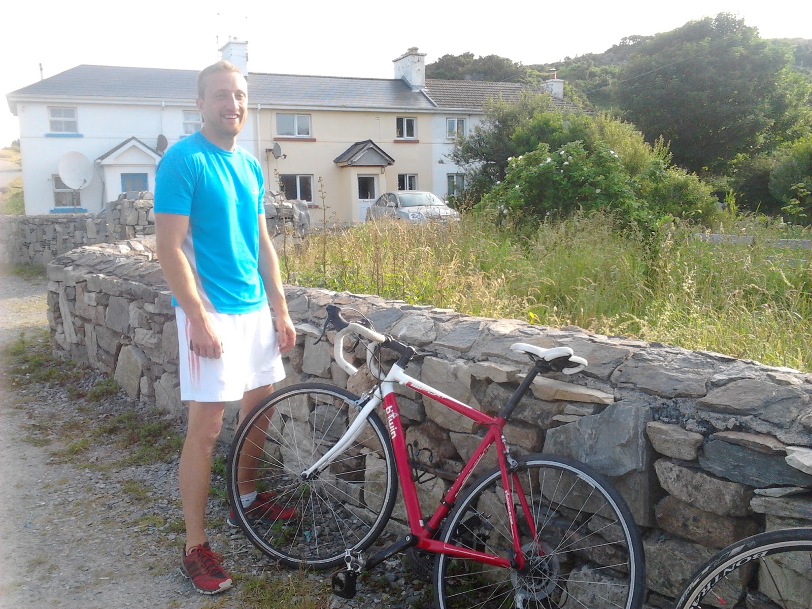
We got up early and after a fine omelette for breakfast we were out and ready for action by eight am. It was another stellar day and the temperature was already high and promised to rapidly go higher. The plan today was to start off with a cycle of a 40K loop from the town to Roundstone via the "Bog Road" and return along the coastal road to town, oh and to throw in a seven K run for good measure. Off we set and we soon left the town behind and after a couple of kilometers we turned onto the Bog Road and were immediately into the wild Connemara landscape. For the next nine kilometers there isn't a house, driveway, electricity pole or any sign of human interference to be seen in any direction. The single track road just twists and turns its way through the most pristine landscape I have found in Ireland and is a constant procession of wild heathland and stunning little lakes and to the north the mountains look simply magnificent. All too soon it was over and we left the Bog Road and turned onto the Roundstone road which was still beautiful but had cars and houses etc. We were soon approaching Roundstone and we turned left off the main road and hid our bikes and set off on our run of the Innisnee Peninsula. 
Now the heat started to be felt and even though I set a slow pace I was to say the least struggling. Right from the start I felt like walking but I reasoned that I would soon loosen out but alas it never happened and I felt progressively worse. The route itself was along little lanes that hugged the shore line of the peninsula. There were lovely views across to the delightful village of Roundstone on one side and the other offered the mountains to excite. I wish I could say I enjoyed it but it was with total relief I arrived back at the bikes. I don't know if it was just my lack of a decent sleep, the snuffles I had the previous evening or just the heat that made me feel so miserable during the run but thankfully once I was again back on the bike I felt better and we set off on the return leg. Now we were in a coastal wonderland. Blue waters lapped onto stunning beaches which even in this weather were almost deserted. It was paradise. We stopped at one small little beach that was actually composed entirely of Coral and its crunchy white sands looked absolutely tropical. We cooled our feet in the sea and set off once again for Clifden. We arrived back in town before noon and we enjoyed a nice break and lunch before setting off on the second part of our adventure.
Ready for the off

From the Bog Road

A coral beach, busy...
In the afternoon we set off for the little village of Letterfrack where we parked up and set off on another cycle. We went along the narrow road by Tully mountain and went all the way to Renville where here we went down to another beach to soak up the views and atmosphere. There were more people about but it still wasn't too busy. Now we had different mountains to look at. In the distance across the bay Mweelrea rose majestically straight up from the sea and to our right the Bencoonagh mountains looked bigger than their modest height would suggest. Everywhere you looked there was another picture postcard view and we both felt privileged to be here in weather such as this and we were enjoying ourselves immensely.
From Renville towards Mweelrea

Loving it


The Bencoonas

Towards the Maumturk Mountains
After a brief stop at the lovely beach at Carrigduff we set off again along the lovely road that runs along by Lough Muck and Lough Fee where the views return to a breathtaking panorama of mountain vistas. We were now heading towards the Maumturks and the Bencoonas were across the water on our right. I tried to keep a good pace and when we reached the main road we were delighted to find it had a super smooth surface and we seemed to fly along. We now had around 10 kilometers left to go so I  pushed as hard as I could but my energy reserves were flagging and the end seemed a long time coming. It was with massive relief we freewheeled into Letterfrack where a cool drink and an ice cream went down a treat. We had covered over 42 kilometers and I think its fair to say we had packed a lot in to our first day in this wonderful area. Another convivial evening of good food and company followed before we retired to recover before our next adventure.

Saturday July 13th;

Maumeen Chapel
There was a layer of cloud blanketing the mountain tops this morning and the temperatures were a little lower. It was still quite warm and humid and it again promised to be a hot day. Today we planned to have a big traverse run of the Maumturk mountains. We parked by Lough Inagh at Garritrissaun and ran uphill on the little lane and then turned right and followed the Western Way until it left the road and turned for north and climbed into the deep gap called Maumeen. This is obviously a place of religious significance and a little chapel and "stations of the cross" are nestled in this peaceful spot. We had traveled almost 10 kilometers by now and we paused here a while to drink and enjoy the peace and total silence of the place. It was again warm and the sun was beginning to burn off the cloud. A little still clung to the tops but the sun was inclined to break through more and more. There followed a steep climb up to the summit ridge and there was little relief in effort as we set a brisk pace. Sweat flowed freely and when occasionally we were blessed by a breeze it was savoured all the more because of the humid heat. The prevalence of Horseflies which found us almost immediately when we stopped encouraged us to keep moving. We were pleasantly surprised at how quickly we covered the almost 400 meter climb to the summit and we were doubly pleased to find that the sun was winning the battle and the cloud was in retreat.


Today a peaceful spot

The rugged ridge of the Maumturks

Cloud in retreat

Too much sugar!!

Some of the ground we covered

We rested a little while and took on more liquids before we set off again along the serpentine ridge towards the highest point of the range Beinn eider Dha Luig at 702 meters some three kilometers away. Despite their modest height the rugged rocky terrain makes for tricky running conditions but we managed quite well and we soon arrived at the high point. Here we finished off the last of our liquids as there was a lake in the next pass and we would be able to replenish supplies there. The views down into the Inagh Valley and beyond to the Twelve Bens was as you would expect glorious. We limited our sightseeing to when we were stopped however as a fall onto the sharp quartzite rocks would have been at best very painful. On the long descent into the next gap, Maumahoge, we had to stop running and walk some steep sections. It was here that Kevin had an epiphany and decided that he would join the elite Green Beret regiment of the army. We then descended the rest of the way and stopped by the beautiful lake and relaxed. We had now covered about fourteen kilometers and climbed over 900 meters and we had a choice to make. We could descend back to the car and return to Clifden and relax, we could continue up the far side of the gap and continue on the Maumturk ridge or we could return to Letterfrack and run Diamond Hill, an iconic little mountain in the national park, we opted for the latter.
The Green Beret

Smashing views

Always looking for more

Great ground for running on the descent

Looking back up to Maumahoge
The descent back to the road was lovely. Dry springy grassy ground was great underfoot and we positively gamboled alone. It was over all too soon and we ran the remaining 2.5 kilometers back to the car in scorching sun. We weren't long getting to Letterfrack and here we enjoyed a fine and well deserved late lunch. We had already covered 18 kilometers and climbed 900+ meters and I was beginning to wonder exactly why I was going to try and run Diamond Hill as well, I guess there must be something of the masochist in me. Anyway after lunch we drove into the nearby visitor center where we parked up and set off on our route. This would involve covering about 7 kilometers and 400 meters of ascent. Two things were immediately obvious, one there were lots and lots of people about and two, I was bollixed. I resolved to walk up and try and run down but as usual I pushed myself and I actually managed to run a fair proportion of the superbly well made trail. An occasional photo stop gave a bit of respite but I was quite relieved when we finally reached the summit just about 30 minutes after we had set off. We took a ten minute breather here and enjoyed the extensive views. Diamond Hill stands apart from the rest of the Twelve Bens so it is a great vantage point to view the range. There were lots of other people about as well and it was great to see so many enjoying the great outdoors. We set off down again and we were soon setting a good pace down the steep steps. The path runs in a loop so we didn't have to retrace our steps, it is also wide enough that there is sufficent room to overtake other users safely, phew. We arrived back at the car in just under an hour after we had started well pleased to have done it, I don't know what I was worried about.
Looking down towards Letterfrack and Ballynakill Harbour

Towards the summit


Looking down to Kylemore Abbey

Looking into the heart of the Twelve Bens
We returned to Clifden for a refreshing shower and a well earned rest. We were so pleased that we had once again managed to pack a lot into our day and we decided that tomorrow would not be too strenuous. Clifden was really busy as I guess there were lots of native trippers taking advantage of the weather and these added to the considerable throngs of tourists milling about. In the "square" there were quite a few sitting outside enjoying a drink and there was a definite continental feel to the place. We ate once again in Guys where we had to eat at the bar counter and several parties were turned away as there simply wasn't room. A great night followed where we enjoyed the music of a local band who played an eclectic mix of everything from U2 to Pink Floyd. It was great.

Sunday July 14th;

I suppose it was predictable that after such a good night there would be the hangover and while neither of us was too bad its fair to say that enthusiasm for exercise was not easy to find. We had a leisurely breakfast and after a quick scout around the town we said goodbye to Sean the friendly and helpful proprietor of the hostel and headed once more for Roundstone. The plan was to hire a couple of kayaks and enjoy a couple of hours on the water.  We stopped and took a few pictures along the way and enjoyed a quick coffee in the village before we headed out to the beach. There was a good few people about enjoying the day and when we got there we decided that we would just relax and chill out. We sat and chatted for a while and as it was now well past mid day we set off on the return journey home. While listening to the radio we came across an item about a newsreader in America who was given spoof names of pilots of a Chinese aircraft that had crashed the day before. Here is a link to the item
http://www.youtube.com/watch?v=kfhfxNIMJjA
Suffice to say there were tears of laughter on our faces periodically all the way home. We were a little sad to say goodbye to such a beautiful place but I am certain we will enjoy other great trips in the future. If you get the chance go and see this great place.
Interesting clouds over the Twelve Bens


Roundstone Harbour

Roundstone

Gurteen Bay

Tranquil waters


Saturday 6 July 2013

Claragh, Caherbarna and the Paps

Friday July 5th;

I decided to take advantage of the good weather and set off yesterday afternoon on the train as far as Millstreet with the intention of heading up into the mountains and having a wild-camping experience. One of my aims is to walk from Millstreet as far as the Atlantic, staying high and wild practically the whole way and carrying my tent and all my food etc. I reckon it will take about 5 or 6 days and if I get the weather it will be one of the best hikes I will have done to date. This time however I didn't have the time to do the whole route but I opted to have a taste of the first couple of days. The plan was to go over Claragh and on to Caherbarna and eventually climb The Paps and then return to Rathmore and get the train home. SO in glorious sunshine I left the train at 13.50 and set off for the long walk into town where the very pretty Claragh rises gently behind. I don't know why but a lot of train stations in Ireland are a considerable distance outside the town and here I had to walk for a couple of kilometers just to reach the town and another 10 minutes and I was at the start of the route up Claragh.
Claragh and Caherbarna beyond

Claragh is a lovely walk


Beautiful "Bog Cotton"
By the "Grotto" you turn left and enter a magical little shady lane that rises steadily through woodland. After a while a right turn takes you through some fir trees and then an open trail traverses the slope and offers great views eastward to Mushera and beyond to my home patch of Mt Hillary. There is more than a grain of truth in the saying that Ireland, when the sun shines is one of the most beautiful places on earth and today it was living up to its billing. The problem is getting the sun to shine. Soon you enter the open mountain and it doesn't take long to reach the summit at 452 meters. There are some masts on the top but it is easy to ignore these as the whole of north Cork and Kerry is laid out below you. It is a great spot to rest a while and soak up the views and sunshine. I was now six kilometers into my hike and I had a long way to go so I didn't delay too long and turned my gaze west and set off for the distant Caherbarna. First there is a lengthy descent to the col and then steadily rise up boggy wet ground to the flat expanse of Curracahill and next contour around above the picturesque Kippagh Lough. Things then rise steadily towards Stoukeen.

Looking down to Millstreet

Caherbarna is still a long way off


Sign of the times
One of the most disappointing  aspects of hillwalking in Ireland is the occasional problems that you encounter with access. Here at the start of the climb to Stoukeen there is a prominent sign denying access to the land ahead. I really don't know why some farmers do this but I suspect it has more to do with greed and farm subsidies than any great desire to protect privacy or landscape. Anyway I had come too far to turn back now and I ignored the warning and continued on my way. The landscape is a vast area of blanket bog that sweeps southwards until it rises again at Mullachanish which is topped by a gigantic communications mast. One thing that is hard to ignore is the large windfarm that stretches for three kilometers from Gneeves. It is without doubt spectacular but whether it is necessary or not I will leave others to decide. I was also keeping an eye out for the landowner as I didn't really want to have any conflict or arguments. Its a pity to have to think of such things when you are out in the wilds. Pretty and all as blanket bog is it does make for tough going. Every step is hard earned and the constant soft ground sucks the energy from the legs. Eventually I reached the broad wet summit of Caherbarna, about eight kilometers from Claragh. I could now see the Paps and also the route down to where I hoped to set up my tent at the col before Knocknabro. The ground didn't exactly get any easier on the way down and I had to cross boggy pitted heathery ground before I reached the col. It did however make it all the sweeter to find a dry grassy patch alongside a stream where I was able to drop my bag and set about setting up camp. It was now 18.40 so I had been on the go for nearly 5 hours and I was ready for a good rest and a bite to eat. After dinner I went to have a look at the lovely waterfall nearby that was now somewhat anemic after the dry weather but it is still a lovely spot. I then relaxed and later watched the sun set before finally tucking into my tent for a well deserved sleep.
Towards "The Paps" from Caherbarna

Wild camping at its best

A beautiful cascade

A nice view to end the day

Saturday July 6th;

I slept fitfully at best and I was still a bit weary when I got up this morning. There was a brisk breeze blowing and a fair bit of low cloud about. I had porridge for breakfast and I was all packed up and on the move at 07.45. It was quite chilly but I soon warmed up on the pull to the broad flat top of Knocknabro. The ground continued in the same vein as yesterday and my tired legs wondered why I was here doing this when I could have been at home tucked up in bed on a Saturday morning like most people, but I got over my self pity and continue on. After the unnamed top of 592 meters there followed a long drop to Lough Glannafreaghaun which sits prettily under the eastern side of the Paps. Bad ground soon got worse and I found myself threading very carefully down through long heather and bouldery slopes that is my least favorite terrain. It would be so easy to have a lapse and twist an ankle or worse. Anyway I eventually reached the lake and here I started on the 450 meter climb to the first summit. Oh boy my legs were tired. I guess I still hadn't recovered from the excellent but tough run from the week before or perhaps I am just getting old but I struggled on the way up and had to stop many times. From the first summit I dropped down to the col and here I left my bag and climbed the 100 meter pull to the western summit. I was now hungry as well so I didn't delay in returning to my bag and I set off down. The ground was consistent anyway but eventually I reached the lake again and here I cooked another bite to eat. The cloud of earlier had long since burned off and it was now quite warm. It was great to sit for a while and the noodles were just what I needed as I was now faced with a 9.5 kilometer walk on the road to reach Rathmore and get my train home.I was also getting a bit tight for time so I set a brisk pace and arrived in the station with just a few minutes to spare at 13.45. So despite the fatigue I had covered 18 kilometers in just about 6 hours. Home beckoned and a shower and a good rest.
Less than glorious first thing

Near the Paps

From the summit towards Killarney

Impressive Cairns

The Reeks and Killarney

Back at the lake

Beautiful lanes

Rural idyll

How the Paps were ever associated with the goddess Danu I will never know

Saturday 29 June 2013

Agony and Ecstasy..The Sheep's Head Run

Some days are just great. Pish weather turns to glorious sun, several hours spent running in astounding surroundings enjoying great company. A nice and really necessary feed afterwards and home to a lovely woman, a good meal and a brew. Does it get better??.

Never too despondent when he 's holding a banana
This morning my alarm went off before 06.30 and I rose blearily to ready myself in good time to get the train to Cork to meet Kevin at 08.00. We were heading west to beautiful west Cork to have a run on the Sheep's Head peninsula. We prevaricated the previous day as to whether to head there at all due to contrasting weather forecasts but when I checked in the evening it looked promising so we were set. Dull was the best description of the weather in the morning but we set off in great spirits and full of optimism of better near the coast. Our optimism seemed well founded as we entered blue sky territory about an hour before we reached our destination. Our delight then turned to, well less than delight, when we entered a bank of sea fog just as we entered the area for our run. Ah well we were here now so even as we parked the car with nothing in the way of a view to be enjoyed we decided that the fog actually made the whole experience more atmospheric.

Down below the fog nearing Kilcrohane

So shortly after 10.30 we were off into the wild landscape and we were immediately delighted with the good condition of the trail and how well it was signposted (quite important in the conditions). We were quickly into a good rhythm and we twisted and turned and went up and down in a torturous topsy turvey route that required our full attention in order to make steady and safe progress. One thing for sure we were enjoying ourselves. We planned to run from the carpark in Tooreen near the end of the "way" not far from the lighthouse in an anti clockwise direction towards Kilcrohane, first of all along the southern side of the "Poets Loop" and then the southern side of the "Cahergal Loop" before finally joining the "Peekeen Loop" and returning along the northern side of these three. I know we had had some dry weather recently but the general condition of the route was superb. Almost nothing in the way of muck and bog barred the way and where we did come across some there was usually stepping stones or a bridge to east the way. All was going swimmingly until we reached BallyRoon where we took a wrong turn and followed the wrong "Loop" and we had ended up running on the road for 4 kilometers into Kilcrohane followed by another 2.5 to the col west of Seefin Hill. This meant we had an uphill pull of nearly 150 meters so when we reached the crest we had a nice rest and a bite to eat.
It was a long uphill pull to the col

Still a bit of energy left..don't ask!

Another half a mars-bar

Heading for the sea

By now we had covered approximately 17 kilometers climbed around 500 meters and been on the move for about two hours. I have to say though that it is almost impossible to really talk about actual length covered or height gained because as I said earlier when we were off road we were constantly switching back and forth and a few steps up were immediately followed by some down. This as you can imagine takes its toll and I was already a bit fatigued, Kevin however seems to be like the energiser bunny and appears to have almost boundless energy reserves, but then he really trains hard and looks after himself very well. He is good though and never lets me dwell on my lesser abilities and is never less than encouraging and up-beat. Anyway after our rest we were off again, this time along the Peakeen Ridge where we were once again off-road and we were still climbing for a considerable while all the way to the summit of Caher Mountain (not I hasten to add the third highest peak in Ireland at 1001 meters found in the Reeks in Kerry). Again the trail was rough but immanently run-able but fatigue was starting to become a factor as was the fact that my calves were inclined to become prone to cramping. I guess that dehydration might be a factor as I only took .75 of a liter of water with me and by now the weather had turned out glorious and a warm breeze and sun were the order of the day. Still there was nothing for it but to go on and lets face it everywhere all about there was so much to draw the eye and inspire the soul. A long downhill section followed across some of the toughest terrain of the day and eventually we rejoined the northern side of the Cahergal route. Wow!, from here things actually got even more stunning. We were now near the sea and we passed some ruins of an old mining community and we were on some of the best, most fun and inspiring trails that I have ever been on. Now the sections when I had to walk became more frequent and Kevin had given his knee a nasty jolt so it was easy to take it a little easier and with scenery like that which surrounded us walking gave us a chance to lift our gazes and drink in the views. There was soon a lovely stretch of just over a kilometer which went gently downhill and a straight springy turfy trail ran all the way to a rocky inlet where there was a poignant tribute to three young girls that lost their lives in this spot over a century before. Breaking waves of aquamarine sea resounded and a stream met the sea with a beautiful little cascade so we rested in this haven for a bit. Ahead the trail rose and fell and hugged the cliff edge and we started to wonder whether we would see the lighthouse that marked the extremity of the route appear after each crest we passed. Wow we were tired by now and the end seemed, and was, a long time coming but eventually we reached the lighthouse and after a quick little explore we sat and basked in the glory of the surroundings and the day. We were pretty exhausted but proud of our efforts. Oh dear, but the steps back up the hill were torture to my rapidly seizing legs and after a while I decided that it was just as easy to run/shuffle along the remaining kilometer to the car.
I bet life was tough here at one time

Tragic past but a glorious spot

This is typical of the type of ground especially on the last six kilometers

A view back from near the end

Little lighthouse

Little Poser :o)

No pictures I can take do the place justice
So after about 35+ kilometers of up down round and about in the most wonderful surroundings and after a bit over four hours we were done. Exhaustion and hunger were prevalent but nothing could hide the smiles.
A rapid replenishment of fluids and a big bowl of soup with a homemade scone was quickly followed by a huge portion of Apple pie and cream and tea and soon hunger was sated and I started to feel vaguely human again. I think we were a source of some bemusement to the other visitors in our disheveled and exhausted state but the lady in the cafe treated us well, hence the huge portions etc. I felt a bit sorry for Kevin as he had to face into the two hour plus drive back but I loved being able to sit back and relax and enjoy the views on the way home. Back in Cork we said our goodbyes and we are really looking forward to our next adventure when we are off to Connemara in the West of Ireland in a couple of weeks for a few days, if we have one day that is anywhere near as good as today it will make it a great trip. Now where's my Van Morrison CD..."When its not always rainin--there'll be days like this....oh my mother told me--there'ed be days like this..na na na nanana"