Monday June 2nd;
On June 2nd I returned to the Pyrenees to continue my journey, which I first began on a trip in December 2011. Then I enjoyed six superb days from Banyuls sur Mer on the Mediterranean shore, to Canigou, which at over 2500 metres marked the true beginnings of the high mountains. Last June I paid a return visit, and continued from Canigou to Ax Les Thermes. This year I departed Dublin and flew to Toulouse, and caught a train from there to the village of Hospitalet Pres L'Andorre, from where I would be able to start my hike. My train from Toulouse didn't depart until 16.45, and as I was due to arrive in the airport at 14.20, I figured that I would ample time to get a canister of gas to have on my trip. But in the way that these things always seem to work out, we were twenty minutes late arriving, and I just missed a bus into town, which meant I arrived into the train station at 15.50. Still plenty of time says I, but as I went to buy my ticket, I was horrified to discover that there was a numbered system in place and a long queue. I was number J25, and the numbers were painfully slow in moving, so at 16.00 I decided to leave and make a dash to a Decathlon store. I knew it was a kilometer away and I figured I needed to prioritize getting some gas. Otherwise, I would have to stay in Ax les Thermes or somewhere similar that evening before I would be able to begin my hike. "Running" with a really big rucksack in quite warm conditions is never easy, and the startled look on the sales assistants face when I entered the store, said all that was needed to describe my condition by the time I got there. By the time I got back to the train station, with my precious canister, I must have been on the radar of the security people, as my heated visage and profuse sweating, must have been a cause for worry. Anyway, I re-entered the ticket hall a mere 17 minutes after I left, and was horrified to find the I had missed my slot by just one number. I went and found an officious looking staff member and explained my situation, and she very kindly took me to the front of the queue. I had my ticket with 15 minutes to spare. I was now able to completely relax and enjoy the 2 hour 35 minute journey.
 |
| Hospitalet |
 |
| Orchids |
 |
| Straight away above the treeline |
 |
| Entering the high valley |
 |
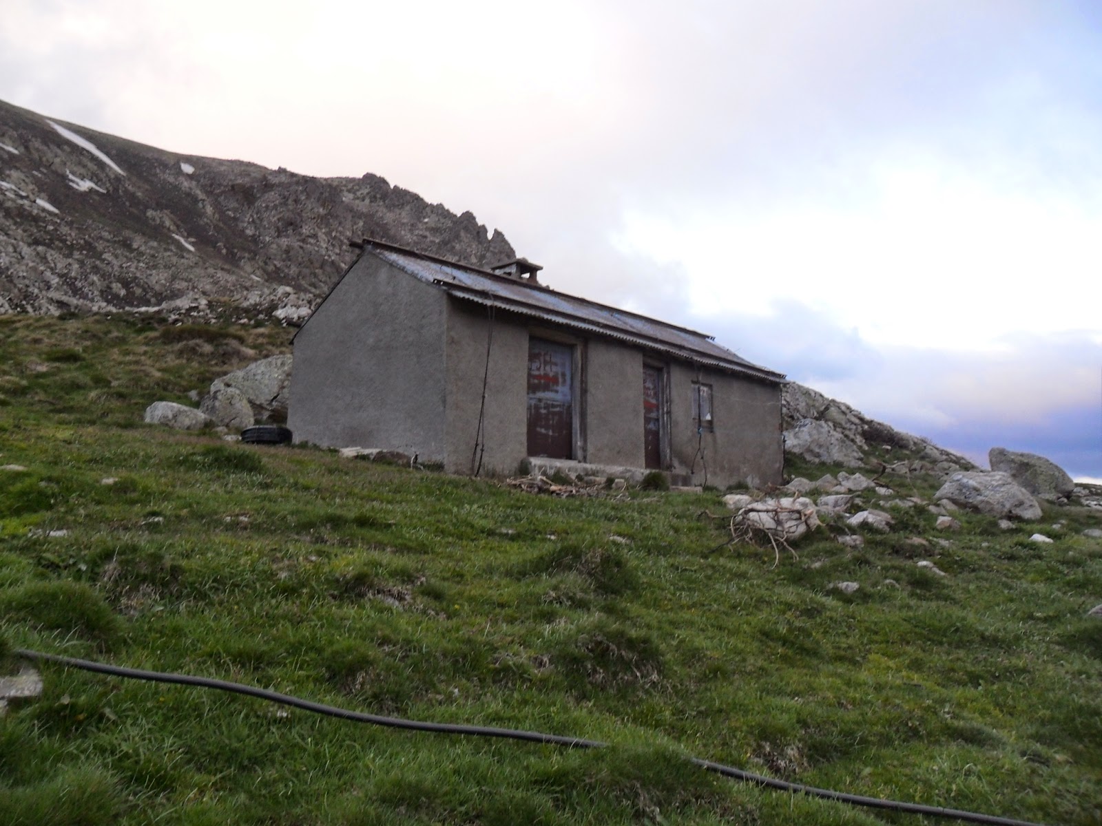
| Brougnic |
On the journey, the predominantly industrial landscape, gives way to intensively farmed, flat agricultural land, before, near Foix, you reach foothills of the mountains. From here, the train winds its way through increasingly dramatic valleys, before finally climbing steeply through the woods towards Hospitalet. I alighted at 19.15, and after a quick consult of the map, I was setting my first steps on the trail at 19.20. Oh my but the bag felt heavy, but I was delighted to be on my way. I concentrated in just putting one foot in front of the other, and I reveled in my alpine surroundings. The trail starts at over 1400 meters, so almost straight away I was in open hillside, and some small hazel trees were the only woodland to obscure the views. The wonderful wildflowers were once again all about, and seeing the stunning orchids and gentians etc, was like greeting old friends. I was immediately relaxed and enjoying myself. Initially, the track rises near a large pipe that feeds the hydroelectric plant in the village, but after a while this is left behind.Then the trail contours around a valley that reaches from the southwest. Here, at over 1700 meters, there were lots of great camping spots available, but I had my sights set on reaching the bothy like refuge Brougnic, that was about three kilometers further on, and at around 2100 meters. I was making reasonable time, and I reckoned I could reach it before dark. I wasn't too worried as I had by tent, and food, so I was set either way. There was a little bit of cloud clinging to the tops, but I was delighted to be able to begin my trip in the dry. It was a little cool but this too was a good thing. Gradually the track rose, and I entered another higher valley at nearly 2000 meters. This wide, almost flat valley, stretched towards the northwest for about five kilometers. In the gathering gloom of the evening, it had a wild remote feel about it. Snow covered peaks were all about, with the most prominent being Pic de Nerassol at 2663 meters. After passing a small lake, I spotted the refuge about 300 meters to the right of the trail, and about 80 meters higher up. It was with great relief I dropped my bag at 21.30, and I set about exploring my new home. It was dark and dingy inside, and the sleeping platform had two mattresses on it. This I didn't like, as I reckoned that these would only provide a haven for critters that hadn't had a good meal for some time, and judging by the amount of rodent droppings to be seen, I would have no shortage of company in the night. That decided me,. and I wasted no time in setting up my tent outside If the weather turned to a horror show, I could always retreat inside. I did make use the table and chairs inside to cook my meal, and it was getting quite dark by the time I finished eating so I decided to settle down to sleep. My little adventure was underway.
Tuesday June 3rd;
After a somewhat fitful night, I emerged from my tent at 06.30 to a great weather morning. There was only a little cloud to be seen, and no wind to speak of. It promised to be a good one. I immediately busied myself with breakfast and breaking camp. When I entered the refuge to ready my bite to eat, the sight of mice scurrying in all directions, confirmed to me that I had made the right choice by sleeping in my tent. I was on the move again at 07.30. My main target for today was to climb Pic de Ruhle 2783 meters, before continuing on the GR10. I set off up the valley until I reached a lake which still had some snow on it before climbing to over 2200 meters and then contouring around and entering the narrow pass and arriving at the beautiful almost entirely snow covered Etang de Couart which nestled under the very lovely, very alpine Pic de Rhule.
 |
| Leaving Refuge Brougnic with Pic de Nerassol behind |
 |
| Etang de Couart with Pic de Rhule behind |
Now the going became more demanding, and after initially crossing a lot of bouldery ground, I had to climb steeply on soft snow, to reach a higher coum. More climbing followed as I headed to the rather lengthily named Portielleide de Ruill ou de Savignac, which sits at just over 2600 meters. Its fair to say that I was struggling. I don't know whether it was my lack of fitness, the soft snow, the heat, or the altitude, but my progress was very much a stop start affair. The climb to the coll was fairly steep, so I opted to head for a rocky spur coming down from its left. That, would at least have me off the snow earlier. The last few steps up to the rock was steep, and the rock wasn't quite as laid back as it first appeared, and before I knew it, I was in a situation which required a few committing moves, where a fall would have been pretty nasty. Still, I got over them, and the contour around to the coll passed off okay. I was tired, but at the same time reveling in my surroundings. Here, things had a real high mountain feel, and I enjoyed sitting awhile and soaking in the scenery and sun. There looked to be a nice scrambly ridge from there to the summit, so after my rest, I left everything behind and set off up. Initially all was great, until after gaining around seventy or eighty meters, I came to a twenty meter steep step, that looked like it may have posed some problems. It was easily by-passed on the right by a snow gully, but I was disappointed to find that here, on the shady side of the rock, the snow was frozen. Whatever about going up, I wouldn't relish descending, without even an axe with me. Bugger and bums to it but I had no option to retreat, and frankly, I didn't feel energetic enough to return to the col and get my axe and crampons so I could make the return journey.
 |
| Above the Col |
 |
| Looking back from the col |
 |
| Home at the Col des Finestres |
So, I turned my back on the summit, and went easily down to Col de Calmettes, and from there to the manned Refuge du Rhule 2185. This was surprisingly busy with guides and their clients, but, as it wasn't yet lunchtime, I just replenished my water supply, and set off up towards Col de Belh. Soon the refuge was left behind, the next section saw me travel along the crest of Crete des Isards, before dropping easily to Col de la Didorte. I was briefly tempted to drop from here to the refuge Ruitort, which looked to be beautifully situated alongside a stream, but I reckoned the 200 meter climb back up in the morning would have been a bugger, so I continued on my way. You are now traveling along a broad undulating plateau, that extends to the ski station on Beille, above Ax les Thermes. I had now been on the move for over seven hours and I was getting quite tired, and finding a good spot for my tent was my next priority. A contour under the next hill was welcome, and the sight of an eagle soaring nearby, made it a pleasant passage. Not long afterwards I reached Col des Finestres (1967 meters), which had a good water-source nearby, so I decided that it would be my home for the night. The cloud was inclined to gather all around me, and I thought there was a chance of rain, but thankfully this never materialized, and I enjoyed a long relaxing evening. I whiled my time reading and recovering after my eight hour day. My only company between that and the following morning, was the sound of hoofs and a few alarm calls from passing animals in the night.
Wednesday June 4th;
Happy birthday to me, happy birthday.....
I stuck my head out from the tent with a little trepidation this morning, as the weather forecast for today hadn't been great. So, I was very pleased to see that the cloud of the previous evening was gone, and that the morning at least, promised to be good. I did my usual ablutions, and was on the move again by 07.30. The views were great, especially the one back towards Pic de Rulhe, which seemed to tease me for not reaching its summit. The following five kilometers along the Plateau Beille, were a delight. Wonderful views all about, and nice easy walking, meant that the time flew by. I reached a pastoral cabin (locked) at Beille d'en Haut, and stopped here to relax for a bit. There was evidence of cattle grazing all about, and later in the season, I guess the cabin would be occupied.Then, the place wouldn't really be a good place to camp, but now, it would have proven to be ideal. The cloud was starting to build, and very shortly after I left the cabin, I was enveloped in the fog. Now, the feel of things took on a much eerier tone, and when I entered the woods shortly afterwards, and the air suddenly filled with howling, I had visions of meeting with beasts from "the hound of the Baskervilles". It was also difficult to now see the markings that gave one comfort that you were on the right track, and sure enough, I managed to take a wrong turn, and I had to retrace my steps back to the turn. Eventually I found the correct way again. Shortly thereafter, I saw the reason for the earlier howling, as I walked past an enclosure full of big dogs, that ranged from German Shepherds, to what looked suspiciously like wolf crosses. They were none too pleased to see me, and I really thought the "private property-no entry" sign, wasn't really necessary. Anyway, I continued gently down in the gloom, and after a while I left the forest and crossed a scrubby, grassy area which contained another cabin (Jasse d'Artaran). This was another place where I found following the markers difficult in the gloomy mist. Once again, I entered the forest and descended all the way down to Caban de Clarens, at just 1100 meters. This is a fine clean basic refuge, that would make a good spot to stay, as the distance between refuges/gites is long on this leg. The weather wasn't getting any better, and the mist was threatening to turn to rain, and the temperature stayed stubbornly in single figures. I was however, still enjoying myself immensely.
 |
| Looking back to Pic de Rulhe |
 |
| Not a bad morning to wake up to. |
 |
| Wonderful easy going on the Plateau Beille |
 |
| More great views |
 |
| Cloud building in the valleys,,,soon to rise |
 |
| The woods in the mist are magical |
 |
| Lots of fungi |
 |
| Strange flowers |
The one problem with losing so much height, was that I had to climb almost 700 meters on the other side of the valley. So far the going had been easy, but now I was faced with my first meaningful climb of the day. I managed it okay, and eventually I crested the broad ridge at 1700 meters. Now I had to search, once again, for the widely spaced way markers on the grassy ground. I eventually found the correct way, and I dropped down once more, to 1300 meters, before rising once again to a lovely valley at Balledreyt 1550 meters. Here a cabin was marked in the map, but it was a ruin, with half its roof missing. The rain was getting a bit steadier, and I briefly considered staying here, but the herd of cattle which grazed all about, with their accompanying bells, decided the issue. I pressed on up the 300 meters or so to the plateau above, and here I was delighted to find a little refuge that wasn't marked on my map. I arrived just over eight hours after starting, and was once again, I was very glad to drop my bag. Here, I had about 10 horses ( of varying types) for company, and only one sported a bell. The mist stayed down but the rain stopped and I entered the refuge to explore. Firstly it was clean with no evidence of rodent infestation, but it did have a mattress on the sleeping platform. There was a good supply of candles and some gas canisters as well. Under the platform was a large collection of tins of various fruits and rice pudding, and on a shelf above, were several six packs of beer. On the wall there was a notice welcoming walkers to the refuge and a price list for the various goods. Guests were requested to pay in Refuge du Rulhe, if traveling that direction, or in the Gite in Sigeur if going that way. What a result, and on my birthday as well. I set up my tent outside again, and enjoyed a most convivial evening with music, beer and some rice pudding for dessert. What a wonderful service.
Thursday June 5th;
 |
| Early morning visitor |
For some reason, the horses, who had ignored me all night, decided that beside my tent was the place to graze at 5am, but even so I awoke refreshed and looking forward to the day ahead. I poked my head outside the tent, and was delighted to see that the mist and rain of the previous evening had cleared away, and the views that had been absent, greeted me now. What a beautiful spot it was, to watch the sun rise from behind Montagne de Tabe, as I readied myself for the day ahead.
 |
| Towards Montagne de Tabe |
 |
| Looking back at the little refuge. |
Just as I was leaving, the cattle from the lower valley, decided to make an appearance, and I was grateful that they had waited until then. Nice easy going followed to Col du Sasc, with just a short pull required to reach the great viewpoint of Pla de Montcamp. A lovely easy walk along the grassy plateau followed, in the glorious sunshine. Yesterdays temperatures in the single figures, were well and truly in the past, and the heat only increased as I made my was down into Gesties, and lower still into Sigeur. Both these villages are lovely sleepy little spots, but I had further to go, so I had little option but to climb again the 600 meters to the pass above Lercoul. Its fair to say I was suffering a bit in the heat, but the water fountains in each village, proved a welcome gift. Here, I left the GR10, and made my way down into the delightful little village of Sem, with its mining history, and then further down into Vicdessos. Once down in the valley floor, the heat was intense, and the three kilometers on the road, when the heat was radiated back at me, wasn't terribly pleasant, and I was really glad to finally arrive at the campsite in Auzat. Another eight hour day was done, and I was very glad to just chill out for the remainder of the day.
 |
| Beckoning me on |
 |
| Wonderful airy easy going |
 |
| The valley awaits |
 |
| Down to Sigeur with Lercoul above |
 |
| The way way back |
 |
| Lercoul |
 |
| The view towards Montcalm from the campsite |
 |
| Tis a tough life. |
Friday June 6th;
The weather forecast at the campsite, promised temperatures in the mid thirties over the following couple of days in the valleys, with strong winds higher up. There was also the possibility of a build up of cumulous cloud in the afternoons, with all the problems that that brings. My objective for the next couple of days was Pic d'Estats, which at 3143 meters, was by a considerable margin, the highest in the Ariege. A climb to the Refuge de l'Etange du Pinet, being the first stage. My first dilemma was getting to the trailhead at Marc (1009 meters) which was over six kilometers away. I could have walked through the valley, but I opted to try my luck at hitching, and lo and behold I got a drive from the first car that was heading up the valley. So it was exactly 9am (according to the church bell), when I commenced my walk. The trail climbs up to over 1200 meters, and then turns left off the GR10, and undulates its way along to L'Artigue, where a fine parking facility is provided for people heading on the various outings that can begin from here. An hour had passed and it was already hot, but at least I would be in the shade for the next while, as I re-entered the forest. A very well designed path ensured that I was able to make steady progress, and it wasn't too long until I exited the tree line, and once again traversed open mountainside, with its wonderful profusion and variety of flora. Across the valley the the snowy peaks of Puntussan and Rouge, were a joy to behold, and the thunderous cataracts that roared down the mountainside, swollen by snow-melt, was a good excuse to pause often and enjoy my surroundings. I was now coming across plenty of snowfields, and at times it wasn't easy to follow the trail, but the ground isn't too difficult, and other ways to make progress are easy to come by. I was making good progress, and eventually I crested the last rise, to see the refuge at 2242 meters quite nearby. I was the only one there and I dropped my bag at 12.30. Not bad as the signpost gave a time of 3.5 hours from L'Artigue and I had matched that time from Marc.
 |
| The church at Marc |
 |
| Is this the smallest car trailer in the world?? |
 |
| Looking back out towards Auzat |
 |
| Looking across the valley towards Pic Rouge de Bassies |
 |
| Alpenrose |
 |
| Looking down to Etang Sourd |
The guardian appeared. An interesting looking character, in denim and braces, that reminded me a bit of a small Gerard Depardiu. Anyway, after checking in for the night with half board, I cooked a lunch for myself and relaxed. Shortly afterwards a couple of guys from Belgium arrived back from the summit, and I was able to glean some information from them. They said that conditions were poor, with one passage where they could hear water rushing beneath the snow, and thought that it might be dangerous to proceed solo. At around 14.45, I decided that I would go for a walk up from the refuge, so I got out my little foldaway rucksack, put my crampons and a bottle of water into it, and armed with my ice axe, I set off up. I set off on a rising traverse of the snow on the eastern side of the steep sided valley, towards Etang d'Estats. The snow wasn't as bad as I thought it would be, and by using the ready made steps, I was able to make good progress. It felt great to be unencumbered by the big bag, and I was able to enjoy my alpine surroundings. I reached the lake quickly enough, and, as not much time had passed, I decided to continue to the upper lake (Etang du Montalm 2568 mtrs), and see what I would do from there. I think I had already decided, but eventually, when I reached the lake, I went for the summit. So far there hadn't been any difficult or dangerous passages, and the next section didn't look difficult either. Now, all progress was on snow, and I was glad I had used plenty sunscreen, as the heat and glare reflecting back at me, were at times intense. Still, progress was fairly easy, and I wasn't sinking too much into the softening snow. Occasionally the sound of sections of snow, suddenly shifting and settling in the sun, put the willies up me, and I wondered about avalanche. I reasoned that the slopes weren't steep enough, ( never steeper than 20 degrees I reckon), so I continued on. Firstly up 100 meters over a shoulder, and then around and up into a final little coum, before finally gaining the easy ridge, that stretches between Pic du Montcalm 3077 mtrs, with its snowy dome, and the slightly rockier Pic d'Estats. Ordinarily I would have detoured to Montcalm, but as I didn't want to be late for dinner, I concentrated on Estats. The ridge passed easily, and gave some nice airy views to the southeast, before I finally climbed the summit slopes and arrived at the 3143 meter summit. What a beautiful spot, which I was able to enjoy all to myself. This was a truly alpine environment, and the snow covered mountains stretched as far as the eye could see into the distance. It was 17.10 when I arrived, and I left again at 17.17. The way back was easy, and I was able to glide and slide down the snow. I arrived a bit tired and hungry, back at the refuge at 18.30 on the dot.
 |
| Heading up from the refuge |
 |
| Contouring above the first lake |
 |
| Heading up to Etang du Montcalm |
 |
| Looking back |
 |
| And it goes on... |
 |
| Finally the summit |
 |
| Happy chappie |
 |
| Montcalm |
 |
| Wonderful vistas |
 |
| Almost back to the refuge |
The two Belgians had departed, and now there was a party of five people in their sixties on the terrace. It seemed I would have company for the evening. I ordered a beer from the guardian who asked me where I was from, and seemed delighted when I told him Ireland. He immediately introduced himself as Patrick. We were set for the night. Very shortly afterwards, a tray containing two bottles of whiskey, a bottle of port, and some wine, was produced, and it was aperitifs all round before dinner. Dinner, I was told would be a half an hour, (good as I was famished). Patrick had very little English, and only one of the group (from Montpellier) had any, so I wasn't able to follow much of the conversation, but they were really nice, and tried to include me as much as possible. Shortly, we were ushered into the inner sanctum of the refuge, where Patrick had a table laid near the cooker. Burners blazed as our meal was readied, and our faces blazed from the generous and continuous aperitifs on offer. I had seen a guitar outside, and when they asked Patrick for a song, he wasn't long disappearing and returning with said instrument. It quickly became apparent, that he could both play and sing well, as could my companions, who joined in with gusto. They had been here before, and promised me a different and good evening. Once those two songs were done, he disappeared again, and came back with an armful of songbooks, which were dispersed among us. A wonderful and entertaining singsong followed, and I joined in where I could, (choruses etc), and even gave a few bars of an Irish song. "Aperitifs" flowed and so did the tears of laughter, before eventually, at the groups insistence, the soup was served at 21.30. It was most welcome and tasty, and during the meal the wine flowed. Eventually, the evening ended at nearly 22.30, but not before a generous nightcap of a local spirit, which I was assured was 55% proof, oh dear. So ended the best night I have ever spent in a refuge, with great company and a most generous and entertaining host. Patrick is indeed one in a million.
 |
| Patrick |
Saturday June 7th;
After the success, in every sense, of the previous day, it was with a tinge of regret I left Refuge Pinet behind me, and set off back down for the valley below. I chose a slightly different route back, and I passed beside the beautiful Etang Sourd, some 300 meters below. This was a nice diversion, and didn't add any time to the route. I had formulated a plan for today, where I would climb from the valley over Pic Rouge de Bassies (2676 Meters), and descend the other side to the Refuge de Bassies at 1650 meters. This promised to be a tough day, but I reasoned that after the success of yesterday, it was do-able, and would see me made great progress in my journey on the GR10. Another sight I wanted to see was the Cascade de L'Artigue, which would mean a bit of a diversion, but I hoped it would be worth it. I continued down until I reached the raging torrent of a river once again, and now I turned up the track towards the cascade. I was already quite warm, and the day promised to be a scorcher. It took longer than expected to reach the falls, and I was astonished to see that it was already 10.30, which meant that I was on the move three hours already. The river was indeed a thunderous affair, swollen as it was with snow-melt. The falls themselves weren't that high, but I was glad I had taken the time to visit them, and the whole river was spectacular. I turned back down and returned to the parking area, where I joined briefly the HRP, before I would turn towards the slopes of Pic Rouge. At least that was the plan, but try as I might, I couldn't find the turnoff; and I ended up heading much further along the HRP than I had intended. There was a possible route up ahead, but it would entail crossing the swollen torrents, and I didn't have a clue whether there was a bridge or not, so eventually, and reluctantly, I turned around and retraced my steps all the way back to Marc. From here I followed the GR10 once again, as it contoured along above the valley, that headed towards Auzat. I was in for a pleasant surprise however, as shortly after Marc, the route followed an old aquifer, in the shape of a large concrete box, that progressed almost completely level, for over three kilometers. This was delightful, and provided easy walking with great views. I even got to see a large lizard, ( at least larger than the usual), who stayed on the edge of the path, and seemed to give me a Robert de Niro stare,,(you talkin to me). All too soon the aquifer ended, and there followed a stiff 200 meter climb, before another lovely, easy, rising traverse towards yet another cascade. This descended from the valley which held the Refuge de Bassies. I even got my first glimpse of a snake on the way, and its distinctive diamond pattern, meant I was later able to identify it as an Adder, whose bite can be dangerous. Still, when I saw it, it seemed more intent on beating a hasty retreat, than any confrontation. I still found myself checking the path ahead a little more carefully. Out of the woods again, and a long but pleasant walk, passing lakes, and greeting new horizons, saw me eventually arrive at the nicely situated refuge at 16.30. I was quite hungry by now, and the cheese omelet I ordered was one of the finest I ever had. I had intended to stay in the refuge, but when I saw that some new arrivals were setting up camp, I asked in the refuge if it was permitted, and once I was given that assurance, I wasted no time in setting up my own home. The heat was intense, and it was with great relief, some hours later, when the sun finally retreated behind the nearby ridge, and the air cooled considerably. A most peaceful night followed.
 |
| Etang Sourd |
 |
| Unusual clouds |
 |
| One of the many cataracts |
 |
| Whitewater heaven |
 |
| The old |
 |
| And the not so old |
 |
| Wonderful walkway |
 |
| I don't see no one else here ! |
 |
| Worth pausing to look back |
 |
| Yet more white water |
 |
| The scenery turning alpine once again |
 |
| Nice bridge |
 |
| Etangs des Bessies |
 |
| Home sweet home. |
Sunday June 8th;
For some reason, I was wide awake before the dawn today, so I decided to rise and pack up, and make an early start. I was on the move after breakfast at six am. It looked like it was going to be another great weather day, as I set off into the glen that rose gently towards the wall of mountains at its head, the highest of these, Pic Rouge de Bassies 2676 meters, was my aim for the morning. The fairly flat valley extended south for about four kilometers, before the route turned east, and rose fairly steeply on a spur to over 2100 meters. From here, a long semi circular traverse, sees one arrive at a couple of completely hidden snow covered lakes, where a straightforward snow plod to the col just to the north of the summit, gives easy access to the airy top. I don't know if it was the lightening bag, (less food), or me getting stronger, but I was definitely much better able to cope with carrying it, and I made steady progress up the spur. The river in the valley floor was a raging torrent, and the bridge that gave access to the correct side for the route, close by the refuge, was broken. This meant that I now to stay on the right bank, until just under the spur, a large, and hopefully very deep, snowfield allowed one to get across the river. I was acutely aware of its existence as I passed over it, and I just prayed that when it eventually collapsed, that it wouldn't be when someone was on it. Anyway, from the top of the spur the traverse was quite easy, and I soon reached the point where I was able to leave my bag and head up across the snow towards the summit. From this point, I would be able upon my return, to traverse under Pic de Caumale, and continue along the ridge-line, before eventually rejoining the GR10 above Port de Saleix. So, very much unencumbered, I easily reached the summit and I relaxed a while and savored my final peak of this trip.
 |
| Looking in the valley with Pic Rouge behind |
 |
| The view back out |
 |
| Extensive snowfields |
 |
| Views at the col |
 |
| Summit |
 |
| Views west |
 |
| Looking across to Pic d'Estats |
 |
| Summit selfie |
 |
| Etang d'Alate back near the GR10 |
I reluctantly left the summit and turned back down. It was now 09.30 and already getting warm. I was really surprised not to see anyone else climbing the mountain, as there seemed to be lots of people in the refuge the previous evening. I reached my bag quickly thanks to some glissading, and set off on the traverse under the next peak. This went relatively uneventfully, except for the brief steep slope, that proved to be surprisingly icy, and not having my axe in hand was a worry. Still, it passed off okay, and I was soon on easy ground and enjoying the ridge ahead. The apparent destination of all those at the refuge now became clear, and lots of people were to be found over the next few kilometers. The final section between Pic de Cabantous and Mont Garias, gave some fine scrambling, which only one other party and myself crossed. Finally all difficulties were behind me, and I descended easily down to Port de Saleix, where I had a decision to make. It was now lunchtime on Sunday, and my flight home was on Wednesday, so realistically, I had only two more days left to go. I had been trying to figure out a way to continue westwards, but the best I thought I could do was reach Seix, where I would still be over twenty kilometers from Saint Girons, from where I could get transport to Toulouse. It could be the one time where hitchhiking failed me, so somewhat reluctantly, I turned to the east, and descended into the very pretty valley that led towards Auzat. It was really hot by now, and my water had long since run out. I had been on a ridge most of the day so far, but the glistening streams in the valley promised relief. I continued down as far as Col de la Crouzette, where an open meadow promised an idyllic camping spot. There was a large family group enjoying a picnic, so I retreated into the woods to the rear to await their departure, when I could set up camp without disturbing them. They took a while, but eventually at nearly 16.30 they left, and I made my way into the field. Unfortunately, as I did so, a gentleman emerged from one of the two ramshackle cabins on the meadows edge, and informed me most definitely camping here was forbidden. So, there was nothing for it but to return to the valley, when I actually went as far as Vicdessos. I was finally was settled at 18.30. Even if you took out the 90 minutes I waited to claim the camping spot at the col, it had still been a long day. I had been on the move for eleven hours in intense heat and I was pretty whacked.
 |
| Port de Saleix |
 |
| Fine rock formations above |
 |
| Heading down into the valley |
 |
| Wonderful alpine pasture |
 |
| It would have been a nice place to camp |
Monday June 9th;
The plan for today, was to climb up a few hundred meters to the village of Orus, and follow the Tour du Pic des Trois Seigneurs, through Illier as far as Lapage, before descending once again to a campsite in the valley floor. I would then continue the following day into Tarascon Sur Ariege, from where, I could get the train Wednesday morning to Toulouse. It was another scorcher, and since it would be a short day, I enjoyed a leisurely morning, and didn't leave the campsite at 10.30am. In the heat, it wasn't long before I was sweating, but my pace was leisurely, and despite having finished with the high mountains for this trip, the scenery and route was beautiful. Orus was a delightful little sleepy spot, and I paused to take a drink from the usual fountain and replenish my supply. I continued on to Illier, where a similarly sleepy spot awaited. Here some children were playing in the street by the fountain, and across the road a toddler was absolutely covered in wet sand, and busily making sandcastles. A little girl, either put some sand on his mouth, or he did it himself, but either way, he was soon in floods of tears, which immediately brought his big sister, (perhaps seven), to his aid. She made a fuss of him, and cleaned him up a bit, before leading him by the hand down the lane. It made for a lovely, quite touching tableau. I moved on, and all of fifty or sixty meters later, I was at the village edge where a tiny little graveyard held the plots of the local families. I stood on the wall by the path, and was surprised to see quite a large snake emerge from the shrubbery just below me, and slowly cross the open ground. It was between four or five feet long, and quite beautiful. I felt privileged to see it in its natural surroundings, in such an unconcerned state. That changed however, when a few moments later it spotted me, and moved with astonishing speed back into cover. Again, for quite a while after, I was a bit more observant of the trail ahead. I continued on, until I finally reached the point where I was do descend to the valley floor. It was only three hours into my day, and I was enjoying myself so much, I decided to forego the campsite, and continue on as far as Tarascon.
 |
| Leaving Vicdessos |
 |
| A rather delightful old building |
 |
| Final views back towards Montcalm |
 |
| Beautiful Illier |
 |
| Quite large but non poisonous |
So I turned left, and climbed the 200 meters to my final alpine col of the trip, at 1226 meters by La Serra. It was a lovely spot, and had a nice welcoming pastoral feel about it. I re-entered the forest, and zig zagged down, until I emerged in a lovely open valley at La Granette. On the big rock face opposite there was a large and impressive scoop in the rock face opposite,where there had obviously been a big rock fall, and there probably was the entrance to a cave at its rear. Wow, but it was warm when in the open sun, but I had no option but to go on. I actually had had very little to drink for the previous hour or more, and I was looking forward to replenishing my supplies in the next village, Genat. Alas, when I reached the village, the usual water fountain was missing, and I had to forego my drink. I followed the trail across an undulating agricultural plateau, until I passed a water trough by a cabin, that promised me a by now much needed drink, but I was thwarted yet again, as a "non potable" sign was on display. To make matters worse, after following the trail markings, I almost ended up back in Genat. This didn't improve my mood any, and added an hour to my day. On my map, the route was only marked as linear, but on 1-25000 maps, there is a loop walk from the village. I eventually found the path down to Quie, where I had my first drink in over three hours. It was now after six pm and I still had a couple of kilometres to go to reach the campsite, so I wasted no time in heading there. I was finally settled and readying a meal for myself at 19.00. A relatively short day, had turned into another 8 hour plus outing, and I was in need of a rest.
 |
| Typical pastoral architecture |
 |
| Charming old barn |
 |
| My final col |
 |
| Impressive rock formation |
 |
| Finally heading down towards Tarascon |
Tuesday and Wednesday June 10th and 11th;
My trip on the GR10 was now finished with, and today I lazed about and relaxed in cooler temperatures. The campsite was very well appointed, and I relaxed for a while in the pool and spa. I explored the charming old section of the town, and was really impressed by the large old church in the square. I even went for a long siesta, I must be getting old. Mostly, I reflected on the trip, and overall I was really pleased with it. It was a little frustrating not to have gotten further west, and ideally, I would have, had a couple of more days available. I might have been able to reach Luchon, which would have allowed me to make better use of public transport. The amount of snow was also something of a surprise, as I think it was as plentiful as last year, which was supposed to have been exceptional. The Pyrenees are exceptionally beautiful range of mountains, which offer the best of all worlds. At times you are walking through steamy forest, and the next crossing a highland plateau, before finally rising into a pure alpine high mountain environment, where snow and rock is all around. All this abundance is matched by the flora and fauna, that compliment and enhance the whole experience. I feel I have to go back.
 |
| A rather public public convenience in Tarascon |
 |
| Typical charming lane in the old town |
 |
| The square in the old town |
 |
| The stunningly beautiful interior to the church (sorry for the blurring) |
 |
| Nice lane by the walls |
 |
| A superb organ in a basilica in Toulouse |
 |
| Enormous and beautiful |
 |
| Interesting tower |
 |
| Odd but intriguing |
 |
| Typical street |
 |
| Fine boulevards and bicycle and pedestrian friendly |
 |
| No need to get lost |
 |
| A rather posh shopping street |
 |
| Nice modern apartment block |
My last day saw me take the train to Toulouse in the morning, which allowed me a couple of hours to walk about and explore this vibrant, prosperous, and beautiful city. It is a pedestrian friendly city, with some beautiful boulevards and buildings. There is a nice friendly buzz about the place, and the two huge markets I came across, were oh so vibrant and oh so French. Definitely a town worthy of a return visit. Now where will I go next ???