
When the weather plays ball, the west coast of Ireland is really hard to beat. When you throw in one of the most beautiful areas on the west coast, then you are on to a winner. When I visit the Dingle Peninsula, I usually head to the northern shores, but this time I headed to the furthest western reaches and headed to a campsite near Murragh, not too far from Ballyferriter. The well appointed campsite was, unsurprisingly, busy but I was ushered to a semi secluded spot that proved perfect for the three nights I was booked in for.
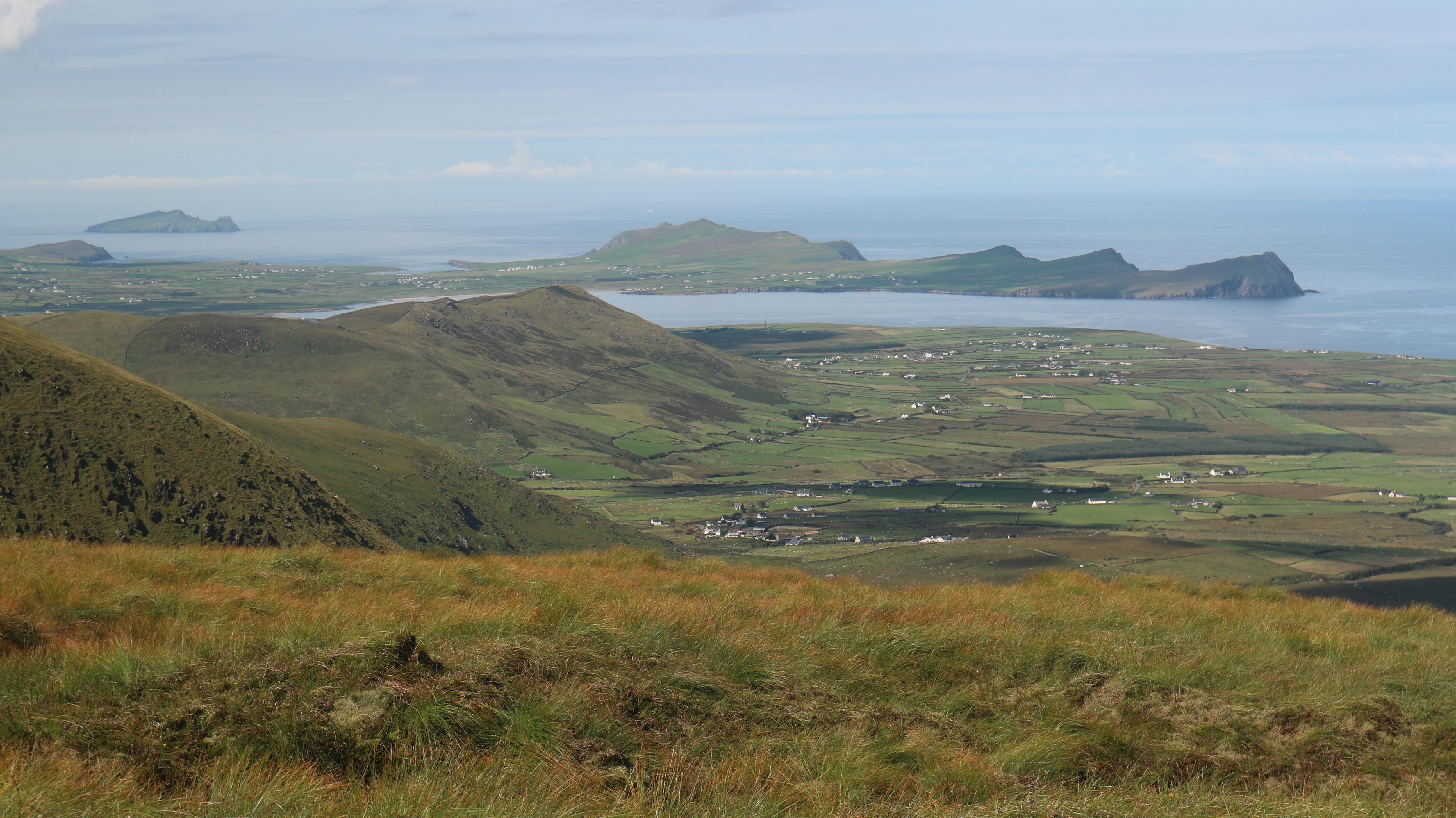
As the day was so fabulous and it being only about 5pm when I was all settled in, I decided that a nice short cycle would be just the ticket before dinner. I should perhaps make some effort to describe where I was. The campsite is situated near the inner curve of Smerwick Bay. The iconic Ceann Sibéal and the Three Sisters are on one side and Ballydavid Head rises on the other. The beautiful Wine Strand lines the shore. As a backdrop you have a hill, behind which, the Brandon massif soars. It is a wonderful complex juxtaposition of sea and mountain that is famous the world over. Indeed, some of the scenes from the final Star Wars movie were filmed on Ceann Sibéal and the Three Sisters. As I readied for my ride, I realized that it was a fair few years since I was last here, and I was really looking forward to rediscovering the area. What better way than a bike ride. My route went along the shore for much of the way, ending up at Brandon Creek. The traffic was light and the scenery wonderful and I loved every minute. From the Creek the road headed inland under Mount Brandon. I rejoined the outward section about 5 kilometres from home and arrived back an hour after setting off. It was just 25 kilometres and didn't have much climbing but it felt good to do something after the drive down. To finally round off the day I walked the kilometre or so to the beach and wallowed a while in the surprisingly warm sea. Watching the sun go down beyond the Three Sisters, as the little waves gently reached the shore was lovely. I felt fortunate indeed.
 |
| A terribly overcrowed and overdeveloped beach |

Saturday August 8th;
If the weather was idyllic last evening, then that word would serve again this morning. A calm, warm, sunny morning greeted me, and it promised to remain so through the day. Having had a wee taster of a cycle last evening, today I intended to enjoy the main course. The plan was to cycle the Slea Head route to Dingle and then climb to the top of the Connor Pass before returning to Dingle and the tent, by the main road. The cycling is pretty easy for the first stages as you round Smerwick Bay and head for Clogher Head. I mean what's not to like?. Mountains on one side, rocky headlands on the other and a shimmering blue sea. And of course, not forgetting the beautiful hedgerows. They are a riot of colour right now, with fuchsia, montbretia, meadowsweet and loosestrife (among others) lining the roadside. I was in heaven. Things actually get even better after that. The pull to the top of Clogher Head was excuse enough to stop and enjoy the expanded views. Now the stunning Blasket Islands were added to the mix and it was heady. Downhill into Dunquin and then the road narrows and climbs up and around Slea Head. Here you are high above the ocean and the road in like a winding ledge cut into the mountainside. These few kilometres are simply stunning. It was such a thrill to cycle there on sucha beautiful morning. Once you cross a ford where a stream runs over the road then more "normal" seaside scenery can be enjoyed. As I neared Ventry the road got a fair bit busier but it is wider as well so there was no problem all the way to Dingle.

 |
| Not bad views at Clogher Head |
 |
| What a road..at Slea Head |
 |
| At the Connor Pass |
There is a road that by-passes the busy town on the northern flanks but it also gives means you have a steep hill to climb. Oh dear, I felt it in the legs and once again I was wondering why I was going to try cycle the Connor Pass. It was only a few weeks before that I went up there and it was something of a suffer fest then. I was hoping for better today. I didn't have the following breeze today but it wasn't against me either. It was equally warm however, so I took it nice and easy in the initial stages. To make a lng cycle short, it was still tough, but I managed it a bit better. I arrived at the top and after a brief rest and a drink I turned and returned the way I had come. What a delightful descent it is. The road is good, with plenty of room for cars. It is not too twisty and you can mostly see when there is anything coming. I wasn't in the mood to really go for it but if you were of a mind, you could have quite the adventurous descent. It is still a complete freewheel all the way back to Dingle. The hill up the bypass had to be done once again but after that it is pretty straightforward all the way back to the campsite. There is a sting in the tail however, when a final 100 metre climb has to be done before a freewheel back to the tent. I arrived back to the tent at 12.15 after covering 56 kilometres, climbed 825 metres in 2 hours 54. I was well pleased.
I relaxed for a while and had a brew before returning to the beach for another refreshing swim. It was still early so I whiled away some more time before deciding to drive to Mount Eagle and climb that. Its claim to fame is that it is the most westerly mountain in Europe. Even though it is well short of 2000ft (516 metres to be exact) it was the expected views that attracted me, and it didn't disappoint. I drove to the saddle between it and the altogether more shapely hill Croaghmarhin (403 metres) and set off at 15.36. I had hoped that there would be an obvious track to be seen but the slope looked overgrown with long grass, some heather and gorse. Down the hill a little I saw a gate and a grazed field that went about a quarter the way up the slope so I opted for that. The field was okay but once out of it on the open ground, it proved to be just as horrible as I had feared. I sweated and swore my way up the slope until suddenly I came to a well made stony track. I was too grateful to question where it had come from and I gratefully followed it up. It went almost all the way to the summit which made the going so much more pleasant. The final steep pull to the top was on a grassy trail and soon I was on the broad boggy summit. The views were as wonderful as I had hoped, especially towards the Blaskets and in the other direction towards Dingle. I relaxed a while and gazed all about before retracing my steps back to the car. That is until I saw a reasonable trail through the horrible ground that led to the car. It would have been so much better if I had found it first time. It had taken only just under 100 minutes and was only 6 kilometres long. Less than 400 metres of ascent was done but it had packed in much in the way of interest and views. I was glad I had done it.It also gave me the excuse to go for another swim before dinner.


 |
| Mount Eagle summit views |
 |
| Not a bad spot for the tent. |
Sunday August 9th;
After my baby hike of last evening, today I was going to have a good outing on Mount Brandon.It promised to be another stonking weather day and I was really looking forward to it. I planned to head to the car park at Ballybrack on the south side of Mount Brandon and try to include as much of the main ridge as I could. It was 09.45 when I parked my car at the already busy car park. It was clear that the normal route would be a very busy affair so I set off across the bog to reach the large valley below Gearhane and Brandon Peak. This had the advantage of immediately leaving the crowds behind and it gave me a nice easy kilometre to start the hike. At least it did until I neared the floor of the valley when I had to cross a deep mire of long grass and gorse. That didn't last long thankfully as I soon reached the farm track that leads deep into the valley. This is a blessing as the ground on either side is wet and rough. At the end of the track it is easy to ford the river and nearby the steep spur that rises to the southwestern shoulder of Gearhane is reached. The end of the valley is backed by a few large coums that form a spectacular backwall to the glen. It was really quite warm and when I started up the steep ground at the base of the spur I was soon sweating profusely. Horseflies were also taking a shine to me and several had a feed before I spotted them.
 |
| That coastline always draws the eye |
 |
| Wonderful and inviting views. Heading into the valley below Gearhane. Went up the steep spur. |

A steep 200 metres had to be negotiated before easier ground is finally reached. This did offer some short little scrambling options, which I enjoyed. Once on the easier ground there was finally a puff of air to cool me down. I was feeling very good and enjoying the wonderful views all about. Eventually I reached the 803 metre summit of Gearhane, where I paused for a long drink. That was the hardest of the climbing over with, and I now had the glories of the main ridge to enjoy. And enjoy it I most certainly did. Normally I follow the track from Brandon Peak to Brandon but this time I stuck close to the edge. While this adds to the climbing a little, it most certainly adds to the views. All the while I was completely alone and I had these wondrous views to myself. That is until I reached Mount Brandon, which was strewn with people. I had a bite to eat here and left quickly to continue along the ridge. Once I was beyond the main paths I was again all alone. I am always surprised and ever grateful that people generally tend to stick to the main summit. Once you leave the honey pot it is always much quieter, and in my opinion better.


Once beyond the Faha Ridge the views are again wild and wonderful. An Sás is always a joy to see and the final top Masatiompán is now not too far away. Perhaps it was the wonderful weather, or perhaps it was that I was very careful to drink plenty, but whatever the reason I was feeling strong and great. I relished every step for the remainder of the ridge and before long I was atop Masatiompán and relaxing. I was surprised to discover that I could see the mountains of Connemara away in the distance. There was much to rest the eye on. I descended and joined the |Dingle Way and this gave a good trail all the way back to the road near Brandon Creek. A lengthy 6 kilometres followed on the road, which was quite tough in the heat, but it passed and I was delighted to arrive back at my car 6 hours 35 minutes after setting out. I had covered 22.5 kilometres and climbed 1450 metres. What a contrast in days to the last time I was on this mountain. Then I had done a quick up and back from Cloghane in continuous driving rain and no views. It certainly hadn't felt like summer then. It most certainly felt like summer a little while later when I washed the rigours of the hike away in the pristine waters of Smerwick Harbour.


Monday August 10th;
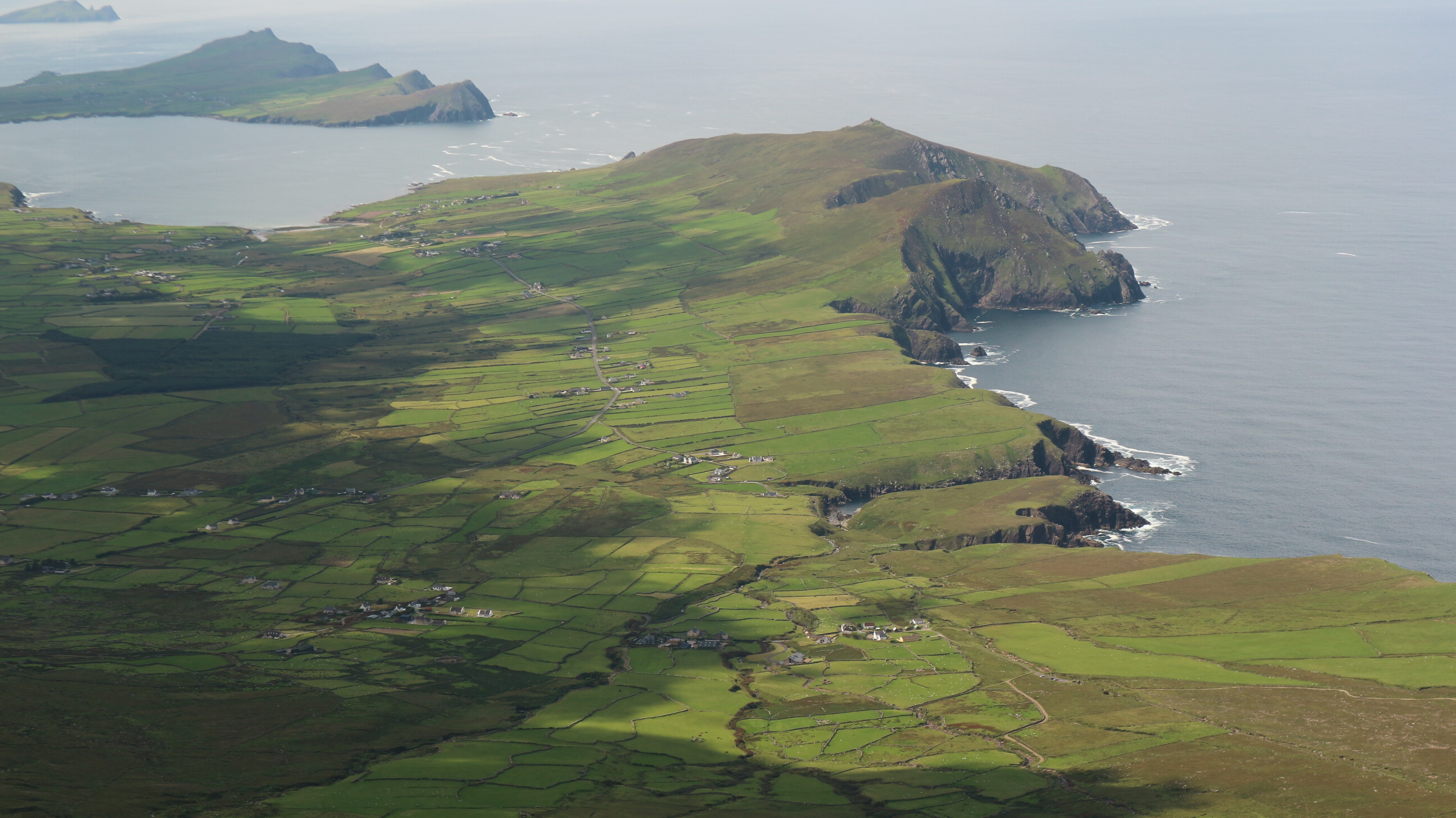
All good things have to come to an end I suppose, and today I had to return home and to night-work. It was somewhat cloudier this morning but still warm and I was hopeful that the cloud would burn off during the morning. I was in two minds as to what to do today. I could do the Slea Head cycle again or I could walk Ceann Sibéal and the Three Sisters. As it was greyer weather I forsook the cycle and opted for the walk. Not that this was in any way second best. The walk is without doubt one of the most lovely coastal walks in the country. I was all packed and on the move by 09.20 and I set off on the short drive to the roads end under Ceann Sibéal. A fine track gives easy access to the higher ground. It was put there a few years ago, when they were filming for the final Starwars movie. At its end it is just a matter of climbing the final metres across a field to reach the crest. A trail them leads up to the nearby summit at 206 metres where a ruined lookout tower. What a spectacular place this it. A vertiginous 600 foot cliff drops into the ocean and to the south the rugged coastline and the Blasket Islands draw your eye. There is a nice flat grass patch near the lookout and I really must pitch my tent there some night. I turned my attention to the continuation of the ridge that leads to, and over the Three Sisters and I set off. Initially I walked but the going is so easy and as I was wearing my trail runners I broke into a gentle trot.


It takes about three kilometres to reach the first of the sisters but the whole way is wonderful and spectacular. One lovely surprise along the way was at a broken cliff and grass section where, just about 20 foot below me, I saw a beautiful fox. We eyed each other for some seconds before it wandered on down the steep ground. Another fox could be seen nearby curled up and enjoying a good sleep. Frequently gannets flew in small groups heading off for some fishing ground or other. What a sleek beautiful bird they are. As I said, I took it nice and handy on the run, and I didn't try to wear myself out too much on the uphill sections. It was all about enjoying myself this morning. The SW, Middle and NE top of the sisters give equally beautiful vantage points along the way. I enjoyed a pause and rest at each one. The NE top is the highest at 153 metres (and perhaps the best viewpoint) and I lingered a while here, somewhat reluctant for the adventure to end. A steep-ish descent on good ground saw me head to near the shores of Smerwick Harbour. One delightful surprise awaited, when I looked to my left and spotted a sizable pod of dolphins bobbing along, just a few hundred metres from shore. I watched awhile enchanted before resuming my run. I soon reached a farm track which became a tarred lane. Then I followed the Dingle way as it went around the busy golf links and I ran the final kilometre upto my car. In all it had been just 2 hours 20 minutes of an outing and I had covered 14 kilometres and 550 metres of climbing. A quick change and drive to the almost adjascent Ferriters Cove allowed me to have a final swim in splendid isolation at this beautiful beach. Sometimes it is worth going to the furthest reaches of a peninsula to find the most unspoiled areas. It won't be as long before my next visit.


