CAHERCIVEEN
Friday July 3rd;
This pandemic life is weird. Work has changed and to be frank, there is only so much gardening a guy can do. Now that the lockdown restrictions have been lifted in the country I decided that a couple of days away with my tent would be just the ticket to ease my travel longings. Normally by this time of year I would probably have had a couple of trips under my belt by now, not including my excellent trip to Scotland in Feb/March. I had thought of heading back to Scotland or The Lakes, and a hike somewhere in Europe in June was also on the cards. That is not to say that lockdown has been hard for me, far from it. I have been blessed by good health and for the most part enjoyed some excellent times at home. Still, I was ready for a little excursion.
I decided to head to Caherciveen on this occasion and stay in the excellent Mannix Point campsite. The weather could have been kinder. Strong winds were forecast for the weekend but not a lot of rain was due. As I drove back the cloudy skies lowered and drizzle swept across the windscreen. All views disappeared and frankly I could have been anywhere. No mountains or sea was to be seen but my spirits were high and a buzz of anticipation course in me. I must confess to having been both dismayed, and to be honest a little frightened, when I saw quite a few English registration cars on the road. The country had done really well to suppress the virus in the community and it was because of that, that it felt secure enough to have a few days away. It somehow felt like an intrusion, or violation, to see foreigners putting this good work at risk. Anyway it was not an overpowering reservation and I continued west. Traffic was quite busy, and I couldn't see any great difference between high season this year or other years. It was almost 7pm by the time I arrived the clearly very busy campsite but I was directed to one of the camping areas and I managed to secure a nice sheltered and relative secluded spot for myself. I was somewhat sceptical that some of larger family tents would survive the strong wind unscathed but bar a couple of broken guy lines they were okay. It must have been a noisy night in them though.
Saturday 4th July;
The weather this morning was just the same as the previous evening. Stiff winds filed to shift the low clouds and drizzle swept across the bleak land. It was not the most promising day for a cycle. If I was at home, getting on the bike would have been the last thing I would have done, but after making the journey down I decided to brave the conditions and go. The drizzle passed and it was just a mist as I pedaled up the rough road out of the campsite. I set my lights to flashing and turned into the wind and set off towards Ballinskelligs. If the weather was better I would have opted to do a circuit over the Ballaghisheen Pass and Caragh Lake and back but since it was so bad the shorter circuit that goes to Ballinskelligs and Port Magee would suffice. The section of road that heads towards Waterville was on the Ring of Kerry and was reasonably busy but it passed okay. When I turned onto the road for Ballinskelligs things were quieter but the wind was now directly into my face and progress was slow. I didn't have much in the way of a view to distract me as the cloud literally hung no more than twenty or thirty metres above the sea. I reached the village and it was a relief to turn right and have the wind helping a little. I was however now going uphill as I headed towards St Finians Bay. I was up in the cloud well before I crested the pass at the shoulder of Bolus Head. To say that the view from the pass is normally stunning is an understatement. It is undoubtedly one of my favourite places in all of Kerry. The mystical and spectacular Skellig Rocks are spectacularly framed from here and it is normally a must stop and take pictures kind of spot. Today however, all was completely hidden from view so I enjoyed the rest as I free wheeled all the way down to the little beach and village at Keel.
I have cycled this route once before so I knew what was in store for me as I once again turned and faced into the climb that had to be done before I could reach Port Magee. Coonanaspic is the name of the climb and while it is not long it is super steep in places. The wind was helping which was a plus and the gradient is initially not too bad. I was lulled into something of a false sense of security. Once you reach the section where the road switchbacks up the hillside, then the strain begins in earnest. I managed to continue to make progress (just) and eventually I turned the final bend and I could see the crest up ahead, tantalizingly close. The trouble is that the road is now at it's steepest and I was barely turning the pedals. Only about 50 metres before things eased back I saw that a couple of cars were coming up behind me. I might have made the top but it would have been touch and go and to be honest I could have just as easily fallen in front of the cars in the narrow road. It was a simple relief to dismount, let the cars pass, and walk the final few metres to the top. The descent on the far side is also steep and provides a fast and exhilarating descent to Port Magee but today I had to keep the brakes on as I was in the fog almost all the way down. Once I reached the village and as I was feeling pretty reasonable I decided to head offshore and include a circuit of the beautiful Valentia Island in my day. This added 21 kilometres to the outing with the final10 of those back into the wind. The big bonus was that once I crossed the bridge back to Port Magee I had the wind directly behind me back to the campsite. Add to this an excellent road surface and I really enjoyed this stretch.
The rain had stayed away and only the odd spot of mist was all I had to contend with. I had coped pretty well with the wind but it was still a relief to enjoy a long warming shower when I returned to the campsite. There was nothing positive to say about the weather but at least I had done something with my day. 71 kilometres covered, 880 metres climbing in 3 hours 10 minutes.

Sunday July 5th;
The cloud and mist of yesterday was thankfully gone and mostly blue skies and sunshine greeted me this morning. One thing that wasn't gone however, was the wind. If anything it was a little stronger than yesterday. I had a choice of things to do today. I could go for a hillwalk or go for a run. I had been looking at the map and there seemed to be a 15 kilometre or so run around Bentee, a hill of 376 metres that rises behind the town. It seemed a better option considering how strong the wind was so I opted for this. I togged out and set off on the run. One thing about starting your run from sea level is that to go anywhere you have to go up hill. It is a gentle enough slope and I wasn't exactly in a hurry so I just ambled along. The hill went on a fair old ways though and by the time I reached the narrow bohereen I had gone for a kilometre and a half and gained over 70 metres. I was glad to turn onto a level road.Well, it was undulating really, but I was able to enjoy reprieves from the hill. At what was I guess the highest point of the road I spotted a marked hiking trail heading directly up the open hillside so on a whim I took it.
Running had to be abandoned for me here, as the slope was steep and rough. I plodded up the slope and gained the ridge line that headed directly to the summit. I now had lovely views down to the complex juxtaposition of land and sea below and it was glorious. It was also quite chilly in the wind and once I reached the summit I wasn't tempted to linger long. The trail continued across the the south east top which offered me a lovely springy descent across the bog before a sharp 40 metres saw me on this top. I was pleased to see the trail continued down the far side and once I neared the bottom I reached a small narrow little road. I fully expected to remain on tarmac for the remainder of the run but it was a delightful surprise when I was directed almost immediately onto a lovely green passage that contoured around the slope. The trail continued in this vein all the way to the town. Once there I stuck to the higher road and this offered a stiff pull to now tired legs. I was however, able to return to the campsite via the same way I reahed this road so the final stretch was all downhill. It was a delightful outing and offered some wonderful and unexpected trail running.It had been an enjoyable 13 kilometre round with over 500 metres of ascent.

 |
| The rather excellent views from the summit of Bentee |
As it was still not yet lunchtime I went for a drive out to Whitestrand and generally enjoyed the wonderful countryside before returning to the campsite. Feeling pretty recovered I decided to head for a short cycle. I went across the bridge and cycled to the pretty harbour at Coonanna before backtracking a little and continuing along the narrow road until I reached the main road back to town. Now I was cycling directly into the wind and it felt like a war of attrition until finally I reached the campsite. It had been just over 50 minutes and just shy of 20 kilometres, but as the final 7 kilometres were so tough I was glad it was over. It had filled out the day nicely and I enjoyed a nice relaxing evening.
 |
| Beautiful and impressive ring fort |


 |
| Guy lines had to be well secured. |
Monday July 6th;
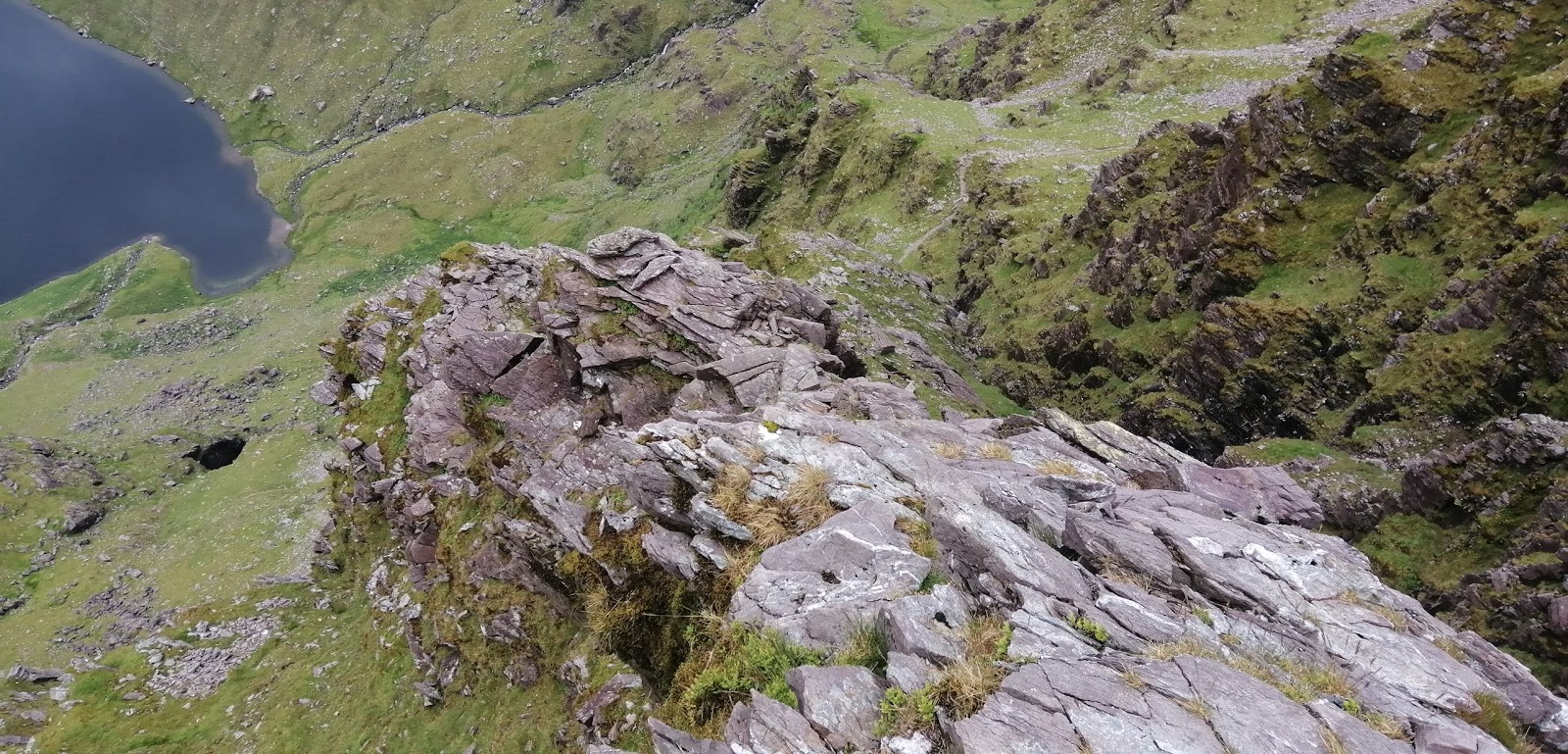
Today I was heading home but I was looking forward to this outing the most. I was going to have a hike on Knocknadobar. It isn't a particularly taxing outing but the view from this peak is one of the best in the country. I always have a soft spot for any mountain that rises directly from the sea and that is certainly the case here. The strong winds of the previous days were thankfully absent and it was a mostly blue sky kind of morning. Some cloud did cling to the summit but I was hopeful that it would burn off soon. I parked at the car park at the start of the "pilgrim route" and set off up. The path is well defined and quite easy as it zig zaggs up the rough hillside.For those feeling super fit, is a route that could provide a possible hill run. After I gained some height, the ridge line on the right looked too inviting, so I left the comforts of the trail and set off steeply to the crest. Once up here the full glory of the scenery is revealed and I enjoyed a delightful stretch along the ridge as I rose towards the summit. At least I did until I reached the stubborn cloud that persisted at the 600 metre level and shrouded the top. I reached the broad stony top just over an hour after setting off, but with nothing in the way of a view I didn't delay in continuing on my way.


Perhaps I should have delayed a little bit and got my map and compass out. I was heading for the north top, but I just took a guesstimate and started walking. When I emerged under the cloud I discovered that I was several hundred metres off line. It was no biggie. The ground is easy and straightforward and I was in no danger. I reached the north top and enjoyed the delightful descent along the broad ridge as it descended towards the pretty bay below. In previous outings I have descended the final slopes to the left and made my way to the pier from that side. Today I decided to try the right (seaward) side and see how passable (or not) this way would be. There were two things I had to worry about. First that I would reach very steep, impassable ground, or have to try and negotiate large swathes of tall bracken. I spotted a well worn sheep track and I decided to follow that. It provided a wonderful route that led all the way to the shore line. Steep drops to the sea were easily avoided and when the weather was so wonderful it was a joy to gaze down on the blue expanse of sea on the way down. Once I reached the rocky shore it was straightforward to follow it all the way to the pier. I then walked the couple of kilometres along the delightful lane back to my car. The whole outing had taken just two and a half hours but it had been very enjoyable and had provided a lovely end to the trip. I was in great spirits for the drive home.
 |
| I do like to be beside the seaside. |
GLENGARRIFF
Friday July 10th;
I was off for another camping trip this weekend. This time the weather forecast was a lot better and I opted to head to Glengarriff. Today I decided I would head for the Sheep's Head and "enjoy" another run on this beautiful area. I planned on going for, perhaps, a two hour outing so I reckoned that if I got there around 14.00 I would be back in the campsite in Glengarriff in good time for dinner. Well, the drive down took longer than I had thought, and it was almost 14.45 when I finally reached the parking area and cafe at the very end of the peninsula. Oh my word, what a glorious place this is. A long drive on ever narrowing roads, sees you eventually arrive in this elevated,wild place. The ocean was a deep blue and the Mizen Peninsula jutted out to the south and the glorious Beara Peninsula stretched far into deep on the northern side. I didn't delay in getting ready and I set off on the delightful initial section that follows an excellent technical trail that runs along the spine of the hill and heads inland. Initially this is tough as you are climbing but after a short while you are mostly descending and it is simply joyous.
The weather helped of course, and today was just about perfect. Eventually after a few kilometres you cross a little road and now the trail follows a green road for a while. Myself and Kevin have enjoyed a couple of outings here before. The first one was over seven years ago (where does the time go?) when we went for a long four hour + outing that was as exhausting as it was exhilarating. It had been my first ever visit to the area and I was immediately hooked. Our next trip was three yeas ago when we went for a shorter outing as part of a weekend trip to Glengarriff. That time the weather had been poor but it was enjoyable none the less. This time I was trying to find a happy medium ground and I hoped to find a route that would stretch to over 20 kilometres and one that I could link up to the fabulous trail that runs along the northern shores as far as the lighthouse.
When the trail reached the road I decided to follow the Sheeps Head Way signs and basically see where I would end up. There followed a delightful few kilometres which wend mostly along grassy trails and descended to the shoreline. It then gradually rose to meet the road that runs from Kilcrohane to my car. I wasn't going to run all the way back to the car on the road so I determined to find a way to cross to the northern shore. I turned up a lane that rose up the hillside, which I hoped would continue to where I wanted to go. It didn't. After a stiff climb and a kilometre in distance I came to a dead end. I searched in vain for access to the open mountain above but everywhere the way was barred by extensive gorse bushes. At least I was able to enjoy the downhill return. A couple of hundred metres further up the road I came to a way marked post and this I decided to follow. It went up a metaled track called the Miners Road and this provided a good test of stamina as it rose up through the steep rough ground. Eventually the road ended at a pretty little lake and then the trail climbed up the flanks of Caher Mountain. Though this peak only reaches 338 metres it is in wild and rough ground. As I got higher I could see the posts were heading away to the east, so when I reached the crest at around the 250 metre contour I decided to cut my losses and make my way towards a little road I could see to the west of me.
There followed a horrible kilometre as I descended through long grass and heather and sometimes gorse was thrown in to sweeten the deal. Rocky spines of rock added to the spice. Let's just say it wasn't running ground. It was both mentally and physically tiring. It was with some delight I reached a different trail that crossed my way just short of the road. After a little indecision I turned right and to my relief I soon reached the trail at the northern shore. By now I had covered around 16 kilometres and climbed over 500 metres (which would normally be a big outing for me) and I was getting pretty tired. Despite this the next section is a delight as it follows a trail that runs above the sea (some exposed cliffs) and through old ruined miners cottages. It twists and turns and eventually you reach a small bay and another lane. Uphill along this for a few hundred metres before you turn and follow a green road that morphs into a rough trail that leads to a delightful spot near a small waterfall. By now I had covered over 22 kilometres and I was very tired. It was such a pity as the next section it perhaps the best of the whole trail. Even though the trail runs along above the sea, don't be fooled into thinking that it is flat. The climbs may be modest but they are there and I found myself walking any uphill stretches I reached. When I reached the point where the trail branched I had to forego the stunning section that heads to the lighthouse and instead I turned and headed for the car. I was thoroughly banjaxed by the time I arrived at the car and I took a little while to relax and re-hydrate myself before heading towards Glengarriff. I had taken a grand total of nearly 3.5 hours to cover the 24 kilometres and there was over 750 metres ascent thrown in. Later while I studied the maps I saw that when I reached the little lake at the top of the miners road I was just 100 metres from the trail I had joined that led to the north shore. that knowledge would have meant cutting out the dead end detour and the grueling, rough hill section. Ah well, hindsight is wonderful. I must go back and shorten the outing a little bit and do the lighthouse section. The Sheep's Head is simply wonderful.


Saturday July 11th;
I had chanced upon the campsite I stayed in by accident the previous evening. As it had been almost 8pm when I arrived at the entrance to Glengarriff caravan and camping, and seeing two signs for reception, one straight ahead, was the office of the site, and the other pointed to the house on the right of the entrance, I reasoned that the office might be closed so I headed to the house. It turns out that they are two separate sites and the one by the house is much smaller, quieter and more basic. It was a great find and one which I would highly recommend.
After the stunning weather of yesterday it was great to rise to another blue sky day today. It promised to remain fine throughout so I decided that today would be the ideal one for a cycle. My plan was to head to Adrigole and from there climb over the Healy Pass. Descend to Lauragh, where I would have a choice of doing the climb towards Kenmare on the main road or cycle along by the sea via Tousist. Then once I reached Kenmare I would return to Glengarriff over the Caha Pass. It is a pretty big cycle for a struggling bicyclist like myself and lets just say that my legs knew they had done a long run yesterday. Anyway, I hadn't come all this way to sit on a chair or lie in my tent so I readied myself and set off.
I took it nice and handy (like I had a choice) and soon I was loosened up. Starting at sea level you gain 100 metres of height in the first few kilometres. The gorgeous views were ample compensation for the effort. A final steep section that is graded at over 10% is mercifully short and there follows a long delightful descent towards Adrigole. Hungry Hill always provides a spectacular backdrop but every direction you turn the views are great. After 15 kilometres I reached the turnoff to the Healy Pass. I have cycled this once before and I knew that it wasn't too bad so I was looking forward to the challenge. The first couple of kilometres are along a verdant fuchsia lined lane which heads directly towards the wild mountains ahead. Soon you enter open wild mountain ground and the well surfaced road twists and turns up the hillside as it rises at a gradient of 5% towards the pass. I was able to make steady progress and with the breeze at my back I wasn't too exhausted at the top. After a brief rest I enjoyed wonderful new vistas as I descended towards Lauragh. The road on the north side of the pass is narrower and quite rough in places so some care is needed. All too soon the descent was over and as I was feeling okay I decided to do the climb out of the village. This is again not too bad and nowhere is it steep but it does go on for four kilometres and climbs 170 metres. I must confess to feeling quite tired by the top but a very enjoyable stress free descent allowed me some rest.
A relatively easy 13 kilometres followed as far as Kenmare before I turned and headed for the final leg of the cycle, the Caha Pass.
The road was rough. It seemed that much of the edge had seen repairs and these were poorly done. Before long it is fair to say I was struggling.I was also now heading directly into the breeze which made things a little tougher. Eventually once I passed Bonane the climb started. The road from here to the pass is good and not too steep. The wild surrounds were a welcome distraction and I eventually reached the tunnel that marks the summit. Now I had covered 68 kilometres and it was almost entirely downhill to the end. The first couple of kilometres of the descent was on a twisty rough road and by now me hands were becoming numb from the juddering. Thankfully the final few kilometres were on a wonderfully smooth road that offered a wonderful respite. I cycled the final couple of kilometres to the campsite and pedaled along the grass to my tent. When I un-clipped my left leg from the pedal, for some reason the bike decided to lean to the right and I managed to have a helpless fall onto the edge of the tent. I was mortified and angry in equal measure. It was an ignominious end to the trip but I was unhurt and everything was undamaged. I was soon relaxing in the sunshine and recovering from the rigours of the day. It had been a big cycle for me. 80 kilometres covered, 1100 metres climbed in 3 hours 40 minutes. The dip in the sea that I enjoyed in the afternoon was the icing on the cake.
 |
| Healy pass south side |


 |
| Grand spot for a dip |
Sunday July 12th;
The wonderful weather of the previous two days was forecast to change today, with more cloud and possibly some rain in the afternoon. With this in mind, and as I was returning home in the afternoon, I decided to have a hill walk in Gougane Barra. This had the benefit of offering me a hike somewhere I hadn't visited before and it was thirty kilometres in the direction of home. I reached the very pretty, very popular lakeside at Gougane Barra and parked my car near the hotel. An easy walk along the road led into the public park. I had planned a fairly long route in a clockwise direction around the valley and lake. My first job was to get onto the open mountain on the left. I found a track that allowed access and I was off. It was calm and humid and I was soon seating as I climbed steeply upward. I chanced upon a wide waymarked trail that was heading in my preferred direction so I followed that more easily. I soon reached the wide crest that led to the first top of the day Foilastookeen at 540 metres. The ground is rough and boggy but generally the going is pretty easy. The views are extensive and I could see from the delights of Bantry Bay right across to the hills that stretch too Mushera. It was the sight of the quite nearby Knockboy that caught my eye the most. I'm not sure why, but I always had it in my head that this mountain (the highest in County Cork at 706 metres) was a rather featureless boggy dome. To my delight and surprise it revealed itself to have several impressive and rather lovely coums and as I walked along I formulated plans for future days.
 |
| By the lake at Gougane Barra |

 |
| Towards Knockboy |
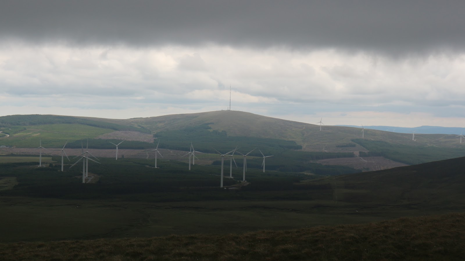
A long boggy descent to a small little lochlan meant a long gentle ascent towards the higher ground that eventually led to Bealick at 537 metres. The cloud was increasing all the time and several squalls crossed over Knockboy. My luck had held up to now but as I reached the top I was finally enveloped in the mist and some drizzle came with it. I didn't last long and soon I was back under the cloud heading across the bog towards Coomataggard SW Top. Between the two summits of Coomataggard there was a large windfarm to the left. When the mist lowered again a couple of the nearest turbines made an eerie sight as they loomed suddenly in the mist with only the bottom of the blades cutting through the clearer air. From the summit the descent went more or less due south and it was made easier when I reached a farm track that led to a bohereen. This led all the way back to the car. I was surprised to see the volume of people and cars that milled down at the lake where parking was now at a premium. I didn't delay in getting changed and set off on the remaining journey home. I had really enjoyed my visit to the area and hopefully I will return. It had been a respectable 17 kilometres with 750 metres ascent in 4 hours 30 minutes.
 |
| There must be some rock climbing to be had there. |
 |
| Almost back to the car. |