Last February I went to the Sierra Nevada for the first time to try and explore these mountains. I knew very little about them and I was eager to discover somewhere new. The weather however had different ideas and heavy snowfall meant I wasn't able to reach the upper slopes. Not being one to be put off easily I decided to return this February and give it another go.
Thursday Feb 22nd;
This time I had no little mishap (like leaving a bag in a taxi 😕) and I arrived at my hotel in Malaga just after midnight. A rather fitful few hours rest followed and I was up in good time to catch my bus to Granada where I could get another bus to the mountain village of Guejar Sierra. From here I could really begin my mountain journey. All worked out perfectly and I alighted in the middle of the village at 11.30.
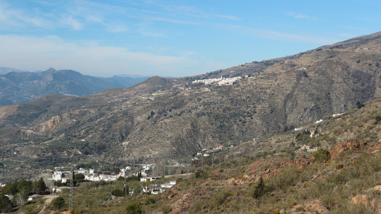
Last year I travelled exclusively on the southern side of the range and this time I wanted to get up close and personal with the northern side. Guejar offered a perfect starting point and offered a choice of routes to the upper, higher, central spine of the range. I opted for the more northerly spur that starts right behind the village as this would give a fine two day excursion to reach the first of the 3000mtr peaks. Mountain villages are beautiful and as the name suggests they are set in the mountains so right from the bus the climbing started. A steep 100mtr pull up through the quaint little streets saw me reach Barrio Alto and I soon spotted the trail-head where I was able to leave the tarmac behind and enter the wild. It was a beautiful blue sky day and the weather forecast promised more of the same for the next few days. One thing that did come as something of a surprise was how cold the forecast was for the nighttime, with temperatures down to -10 at around 2500mtrs. It was another indication that despite being at the far south of Europe, these were big mountains that were firmly in the grip of winter. Not that it felt that way down here as there was heat in the sun and spring was definitely in the air.
 |
| Rising above Geujar Sierra |
 |
| Up to the col then follow the skyline |
The trail wound its way steeply up through the scrubby vegetation to reach the crest of the broad spur at Alto del Toril at almost 1600mtrs. Despite being fully laden with five days food and clothes and hardware for winter I was very pleased with my progress to the crest and I was feeling strong. The views of the north side of the main ridge were alpine and spectacular and I was really looking forward to reaching there. I was somewhat surprised with the snow conditions as I had been led to believe that there was heavy snow cover to quite low levels but the spur that I was on seemed basically snow free on its crest and southern aspects to well over 2000mtrs. I had been all geared up for snowy campsites where I would have to bury my axe and walking pole sections to make anchors but it seemed that this wouldn't be necessary. I'm not sure if I was relieved or a little disappointed, perhaps a little of both. Anyway once on the crest the going was pretty easy. Next up came Alto de Calar at over 1860mtrs and from there the trail undulated over several tops before reaching Cerro del Tamboril which reached over 1900mtrs. After this I reached, what is a feature of these mountains, a dirt road crossing the ridge. From here on things started to take on a little more wintry aspect with large snow patches covering the ground. Time was still on my side but when I reached a level grassy spot with a trickle of spring water at Fuente de los Amigos I decided that it was too good a spot to pass and decided to camp there for the night even though it was still before 4pm.
 |
| Spectacular north side of Sierra Nevada |
 |
| Not a bad spot for a campsite :) |
 |
| The way ahead tomorrow |
 |
| Fire at sunset |


I soon had my Vango Force 10 Helium 2 tent set up and I settled in to enjoy the remaining daylight. Up here at around 2200mtrs there was a sharp chill in the air and things promised to get decidedly cool later on. In the nearby scrub there was the occasional dead Juniper bush and I decided to collect some of this tinder dry wood and enjoy the benefits of a little fire. This had the double benefit of keeping me occupied and gave some welcome heat as the evening progressed. For my last couple of hiking trips I have used Voyager Outdoor Meals to feed myself and I must say I would highly recommend them. They are simplicity itself. You just pour in some boiling water, mix up the dehydrated ingredients inside, seal the top and after approx 5 minutes enjoy a tasty and filling meal. This also means that in one go you can boil enough water to make a brew as well and this is ready for you once you finish the main course. It saves in the use of gas and a 250 gram canister will last for a long time. My my but the views were good, and when the sun started to get low in the western sky the landscape became a riot of fiery red as alpenglow worked its magic. I relaxed into the gathering gloom but eventually the cold made me head for the comforts of my sleeping bag. It was reading -3 at 7pm so it promised to be a cool one. I didn't sleep well at all but thankfully it wasn't the cold that kept me awake despite the temperatures reaching minus 7.
Friday Feb 23rd;
One of the problems with camping in the winter is the length of the night, especially when it gets as cold as up here. Huddled up in the sleeping bag for 12 hours eventually becomes wearing both physically and mentally but I actually felt surprisingly good this morning. I stayed in the sleeping bag as I set the stove to boiling the icy water in the pan and while I waited for my (Voyager) cappuccino muesli (yum yum)to do its thing I snuggled back into the warmth. It was reading -7 on my watch but the air was so dry in this alpine environment that there wasn't a sign of frost on either my tent or the ground. After eating I quickly set about breaking camp in very crisp blue sky morning and I was on the move again at 08.45.
 |
| Grand day for it |
The plan for today was to first head as far as the pass under Loma de Jerez which I would climb before heading around to La Buitera before descending to the bothy like Refugio pena Partida (2450mtrs) from where I could possibly tackle Mulhacen the following day. That would give a nice horseshoe outing and would climb three or four 3000mtr plus tops. Once again I was surprised by how the difference in scale of these mountains manifested itself. I had expected it to take no more than an hour to reach the pass but it took me a full two hours to get there. The going had become a little tougher with long sections of snow to negotiate but it is really just the sheer scale of the mountains that is slow to sink in. The Sierra Nevada are the second highest mountain range in Western Europe and this morning I was having little difficulty in believing it. Anyway I reached the pass and I had thought that crampons and axe would have been necessary from here on but the snow wasn't icy and the angle was quite laid back so I was able to continue on as I was.
 |
| Should have been easy but I struggled |
The slope was broken up into two sections. The first climbed 400mtrs to reach the shoulder at Cero del Mirador Alto before a level section reached another 400mtr climb to reach Loma de Jerez at 3100mtrs. I don't know whether I was unfit or whether it was the altitude or perhaps a combination of both but it is fair to say I struggled mightily. Once I reached around the 2500mtr contour the wind increased in strength and at times needles of spindrift stung my face. Despite my struggles it was wonderful to have the experience of deep winter and I was enjoying myself immensely. The second half of the climb I found harder than the first and by the time I was nearing the top I was reduced to taking perhaps as little as twenty steps before I had to stop and catch a breath...what the ##ck??. All this meant I had taken a total of 5 hours to reach this point and my slow progress meant I was also feeling the cold a bit more. When I reached the cairn at the top I was in need of something to eat and I took shelter from the seriously cold wind. I have seldom struggled as hard to climb such a modest slope and I reckoned that perhaps I needed to rethink my plan to head for the refuge as to climb Mulhacen from there with a full bag would be a much bigger undertaking. From the leeward side of the shelter I got the map out and decided to head for the mountain village of Trevelez from where I could climb Mulhacen. Did I mention it was cold??. Well it bloody well was..seriously cold. I don't know what the temperature was but when it was coupled with the strong wind it felt bitter. As I was eating I suddenly realized my mouth had gone numb and I was like someone that had just come out of the dentist. I suddenly found this highly amusing which made me laugh which meant food was wasted which made me laugh more..oh dear.
 |
| East from the summit |
 |
| So cold |
 |
| Towards Mulhacen |
Up here the landscape resembles the Cairngorm plateau as it undulates away to the west. The ground was scoured of snow so crampons were still not necessary as I headed across the gentle slope towards the nearby top of Puntal de Juntillas which at 3146mtrs would be my highest point of the day. From the summit a very inviting snow slope dropped easily into the valley below Puerta de Trevelez. This I hoped would give a swift easy descent and I could lose about 500mtrs in height. I was even hopeful that a glissade would cover the whole thing..I was wrong. Despite the cold, the southern sun had done its work on the snow pack and far from glissading I found myself post-holing much of the way down which eventually became exhausting. Eventually I reached the end of the snow at around the 2500mtr contour where the valley becomes quite narrow. Now I was able to follow a track as it contoured around the spur and once on the southern side of this a trail descended towards the huge deep glen that would eventually reach Trevelez. Time was passing swiftly and it now became clear to me that the village was still a long way away. I needed to push on if I was going to get there before dark. One welcome distraction to my growing fatigue was the stunning views across to the huge alpine sight of the main ridge and the wonderfully named Alcazaba.


I was still up pretty high at over 2400mtrs but once I dropped down the spur to the narrow valley I had lost another 400mtrs. Once down in the sometimes gorge like valley the trail twisted and turned and sometimes went up and down and followed close to the Rio Trevelez. I had stopped to book into the Refugio Alpujarra Alto in the village and I was really looking forward to reaching it. The trail was interminable and I began to despair of ever seeing the whitewashed houses of Trevelez but eventually in the gathering gloom they appeared blessedly close by. I entered the village near the church and thanks to the wonders of Google Maps I was able to be guided through the jumbled maze of little alleys directly to the refugio. Trevelez is (surprise surprise) built on a steep slope and there is over 150mtrs in height difference between the lower homes and the highest. As can be deduced by the name the refuge is in the higher section of the village and this meant I had around a 70mtr steep pull to reach my haven. Another thing about establishments in these villages is they are discreet. No garish flashy signs here and when my guiding voice told me that the refuge was on my left I could see no sign of it. Thankfully a little closer inspection revealed a little sign directing me to the rear of the building where the reception was located and I was finally home over 10.5 hours after setting off. I was greeted warmly by the hostess and I had a 5 bunk room to myself that night. I feel I should say a few complimentary words about the refuge/hostel. It is superbly well appointed, beautifully (artistically) decorated, spotlessly clean and great value. If you are ever fortunate enough to find yourself in Trevelez, look no further for somewhere to stay than here.
Saturday Feb 24th;
I emerged from the refugio to a sunny, chill morning after enjoying a tasty breakfast replete with homemade treats. I soon found the trail head for todays route and I was off. The plan for today was to go as far as the excellent Refugio Poqueira which I had stayed in the year before. This I hoped would give a reasonably easy day but on closer inspection of the map I realized that I would have to climb over Alto de Chorillo 2721mtrs which would mean a climb of over 1200mtrs. I hoped my struggles and exertions of the day before wouldn't hold me back today. The trail wound its way above the village and, in the way mountain trails do, height was gradually but steadily gained without too much pain. I was very pleased to find I was moving well and I was able to maintain a steady pace and keep moving. Cloud that had welled in the lower valley gradually rose up as the morning progressed and eventually it engulfed the upper slopes. It wasn't a problem though and the well defined trail ensured I stayed on course. Eventually I crested the broad ridge and it was strange to fine it was almost entirely snow free here at 2700mtrs and when the clouds cleared I could see that the snow was only in small patches even on the much higher ground that rose towards Mulhacen. A half kilometre walk on the crest was a joy before joining the trail that dropped 200mtrs over the next few kilometres until I reached the large refuge. From the steady streams of people that were heading to the refuge it was clear that I wouldn't have it all to myself like I did last year. I checked in at lunchtime (it had taken me just 4 hours) and settled in for the evening. The refuge was totally full by the time the evening came.
 |
| Leaving Trevelez |
 |
| Dry arid countryside |
 |
| Gaining height |
 |
| A road at over 2700mtrs |
 |
| And snow free to much greater heights |
 |
| Refuge..Fair to say I wasn't going to be alone |
Sunday Feb 25th;
As we had went to bed the night before the skies had been clear and the forecast was for a blue sky day today but alas it was wrong. The upper slopes were mostly covered in cloud but I was hopeful that as the morning progressed things would clear up again. One great thing about starting my climb of Mulhacen from the refuge was the fact that I was able to leave two bags of stuff that I wouldn't need on the climb with the Guardienne. I basically had an empty bag except for crampons and extra clothes and food. An easy trail leads initially west from the refuge until it enters the steep sided valley that rises towards Colado del Ciervo on the main ridge from where a right turn leads to the summit slopes of Mulhacen which at 3482mtrs is the highest mountain in mainland Spain and indeed on the whole of the Iberian Peninsula. Finally at around the 2700mtr contour I got to put on the crampons when extensive hard-packed snow fields were reached.It felt good to be using crampons again and this helped to give a more alpine feel to the morning. The cloud was being stubborn and if anything was getting thicker as I got higher and eventually I was enveloped in the mist well before reaching the col. Not that I went as far as the col as there didn't seem any point when no views were to be had. Instead I climbed the slope at an oblique angle as it headed directly for the summit. This gave a 500mtr climb at around 25degrees which again I found tough. The snow initially was that frustrating type where you managed a few steps on the hard crust before breaking through and struggling for a bit before repeating again and again. Higher up the slope was scoured of snow but was quite icy but at least you knew what to expect then. Eventually the summit cairn loomed in the mist and I had reached the highest point in the Iberian Peninsula. It was a pity not to have any views to enjoy but at least it wasn't as windy as when I was on Loma de Jerez a couple of days before and it therefore didn't feel as cold. I relaxed a little while before setting off down. I was annoyed with myself to discover that I had left my map in the refuge but I asked a group of young guys that were on the summit what direction they were taking off and as it was the way I wished to go I decided to follow them. So having ascended from the west we set off in a southerly direction on very easy ground that would eventually lead to the spur I crossed over coming up from Trevelez. The ground was almost free of snow and heavily cairned so once I had my bearings I left the group behind and continued alone. Eventually I re-emerged under the clouds and enjoyed my amble down the wide easy slope. Again the comparisons with the Cairngorms come to mind as this is big open country up here. I eventually reached the now quiet refuge where I had a bite to eat before re-packing my bag and setting off down towards Capileira. The descent went well but it was still nearly 4pm when I entered the village. I checked into the basic but excellent Hostal Rural Atalaya where a comfortable night followed. It had been a substantial day of over 8 hours with 1000mtrs of ascent and 2000mtrs of descent.
 |
| Finally time for the crampons |
 |
| It promised but no clearance came |
 |
| Back under the clouds..big open and wild ground |
 |
| Of course the clearance came too late for me |
 |
| For me the lower valleys are more spectacular |
Monday Feb 26th;
I was now finished with the high mountains and the plan for my remaining two days was to hike the Gr7 as far as Niguelas where I could get a bus to Granada. The target for today was to try and reach Lanjaron, some 27kilometres distant.
Of all the "White Villages" I have visited I think Capileira is my favourite. It is slightly smaller (and lower) than Treveles but it is perched on the steep slopes of the deep valley at the bottom of which rushes the Rio Poqueira. Again there is almost 150mtrs in height difference between the lower houses and the upper ones and if you never went anywhere else you would get fit exploring its chaotic jumble of steep whitewashed alleys. Further down and at the same side of the valley lie Bubion and Pampaneira and the trail enters each of these. It was a lovely start to the day. A frosty sunny morning was just the ticket and easy walking meant I could savour the great views as I descended. The trail just touches the edge of each village and soon enough I was down at the hydro station below Pampaneira having lost nearly 500mtrs in height. A quick search and I spotted the marker for the continuation of the trail and I set off again. One thing they don't do very well here-abouts is mark the trail. In places they use timber posts but these are sometimes overgrown with shrubbery so it is easy to lose the trail. This of course I managed to do. The trail contours around a headland and once you round this new vistas can be enjoyed. Ahead several villages nestled in the hills and I was trying to figure out which one was the next on my route Soportújar, Spring had definitely sprung down here and it was delightful to see so many butterflies and have so much birdsong for company on the way. It must have also been close to the mid teens temperature wise which also gives another indication of the sheer scale of these mountains that are still in deep winter higher up.
 |
| Leaving Capileira |


The village I had picked out as Soportújar was in fact Cánar and I found myself walking into Soportújar earlier than expected as it was hidden from sight around a headland until the last minute. What a delightful little place it was. Witches obviously have a big role in this village and throughout its whitewashed streets various artworks and sculptures pay them homage. It was a delight to walk through and the artworks were interesting and fun. I found the trail exiting the village which led into a long steep sided valley that extended the walk to Canar by a considerable margin. Eventually I entered the sleepy little village and set off on the final leg of todays journey. Another circuit of a steep sided glen saw me emerge up an eroded path to reach a roadway. Here a jumble of animal tracks and the total absence of markings meant I struggled to find the correct route but after a bit of tooing anf froing I was on track again. That is until I lost the trail again and so to make a long story short I followed the Gr142 for the final few kilometres down to Lanjaron. I don't know whether the markings have been removed of vandalized but it seems that just where things are at their most confusing (junctions, multi tracks etc) there is at times a distinct lack of signage. Or maybe it's just me. Anyway it is super frustrating and things weren't helped by the fact that my map had all but totally disintegrated by now. I had booked myself into the cheap Hotel Lanjaron ( a bit of a dump) which was at the far side of town but it was easy walking for those last couple of kilometres. I remember passing through Lanjaron on the bus last year and it hadn't made a great impression then and I must say that now I felt it has a somewhat rundown feel about it. Perhaps it wasn't helped by the fact that practically every place of business was closed (it was a Monday after all ). After settling in to my room I went in search of something to eat but any restaurants seemed closed and after searching high and low and just on the point of giving up I found a tiny supermarket open and I was able to get some cheese and bread so at least I didn't go hungry.
 |
| My mirror image in Soportujar |
 |
| These seedheads are easily 7mtrs high |
 |
| Approaching Lanjaron |
Tuesday Feb 27th;
I found the trail out of a still sleepy (and seemingly closed for business) Lanjaron at 9am and set off for my destination for today Niguelas. This should provide a fairly gentle finish to my journey as it was just 17kilometres and the highest point I would reach would be just over 1300mtrs so I was easy of mind in the knowledge that I had lots of time and would comfortably catch a bus into Granada that evening. There had obviously been a fair bit of rain overnight and a stiff breeze was blowing as I rose above the town. Today the trail was almost exclusively on dirt roads so the going promised to be easy. The rain seemed to be staying away for now and the views were still spectacular across the valley and to other ranges further afield. Eventually the bulk of the climbing was done by the time a reached a family recreation area but alas the rain also decided to make an appearance so I had to don the outer shell. It lasted for nearly a couple of hours but it didn't detract from my enjoyment as I found myself walking through hundreds and hundreds of hectares of almond groves which were full of blossom and at times heady with scent. I stopped for a bit to eat on the edge of one such grove and the scent must have got to me because I had walked about a kilometre again before I realized that I had left my walking pole behind and I had to retrace my steps..17kilometres had just become 19. Some big deep valleys were walked around until eventually under Cerro de Molinero I reached perhaps the most spectacular one yet which was just before the final descent into Niguelas. The weather had cleared up as well by now and I could see fresh snow fall not too far above the level I was walking at. A steep but rapid descent leads swiftly to Niguelas and I was back where it all began for me just over twelve months previously. As it was only just past 2pm when I reached the village and my bus not leaving until nearly 4pm I decided to walk to the nearby village of Durcal which was quite close by. I didn't have a map but I followed the gr markings in the hope that they led there..they didn't. After fifteen minutes or so it became clear that the Gr markings were heading in the opposite direction I wished to go so I just used Google Maps to plat a route instead and enjoyed a nice walk into Durcal. I arrived at the bust stop in the centre of the town at 15.25 and I was delighted to discover that there was a bus to Granada leaving in five minutes..result. I enjoyed the ride into the bustling city of Granada and another two kilometre walk saw me at my hotel. Another journeys end.
 |
| Above lanjaron |
 |
| The rain arrives |
 |
| Stunning Almond groves |
 |
| Approaching Niguelas with Durcal beyond |


So came to an end my second trip to the Sierra Nevada/Aljapurras and this time I got to experience the high mountains as well as the wonderful lower slopes. I got a much better sense of the sheer size and scale of these mountains. The massive length of some of the spurs and ridges gives some indication and the intense cold (even so far south) on the main ridge over 3000mtrs leaves you in no doubt but that these are serious mountains. That said would I go back again???...probably not. Despite their size they are really hillwalking mountains. I know that climbing can be done on the north side but lets face it a mountaineer has far better destinations to go to where such fun can be had. Perhaps it is the network of roadways that seem to criss-cross the whole range but there is not that wilderness feel to be had either. It is the deep spectacular valleys, dotted with beautiful villages that hold the real charm of the area for me. The people are very friendly and the flora and fauna is different and beautiful. The villages are beautiful and glimpses of old world lifestyles are still to be found. I am glad I went but for me different landscapes beckon for the future.