Last weekend I went with Frank to Connemara for a few days hiking/climbing. Though Frank has been living here for over sixteen years now he had never been on the Twelve Bens and indeed it had been quite a while since I had climbed them myself so I was really looking forward to the chance to re-acquaint myself with them. I had booked the week off work in order to try and make a start on the many chores that need seeing to after the builders left but an enduring pernicious cold/virus had me feeling under the weather for a full month and I hadn't been able to get much done. I had intended getting away for a few days and would have probably hit on Snowdonia but Frank suggested we aim for Connemara and I readily agreed. We set off Thursday evening after Frank's work and made good time and we settled into the excellent Clifden Town Hostel at about eight thirty where Sean (the proprietor) soon had us settled into a twin room and we relaxed for the evening. I had started a course of antibiotics the day before and I was feeling a bit whacked but I was hoping that better days were soon to arrive.
Friday March 28th;
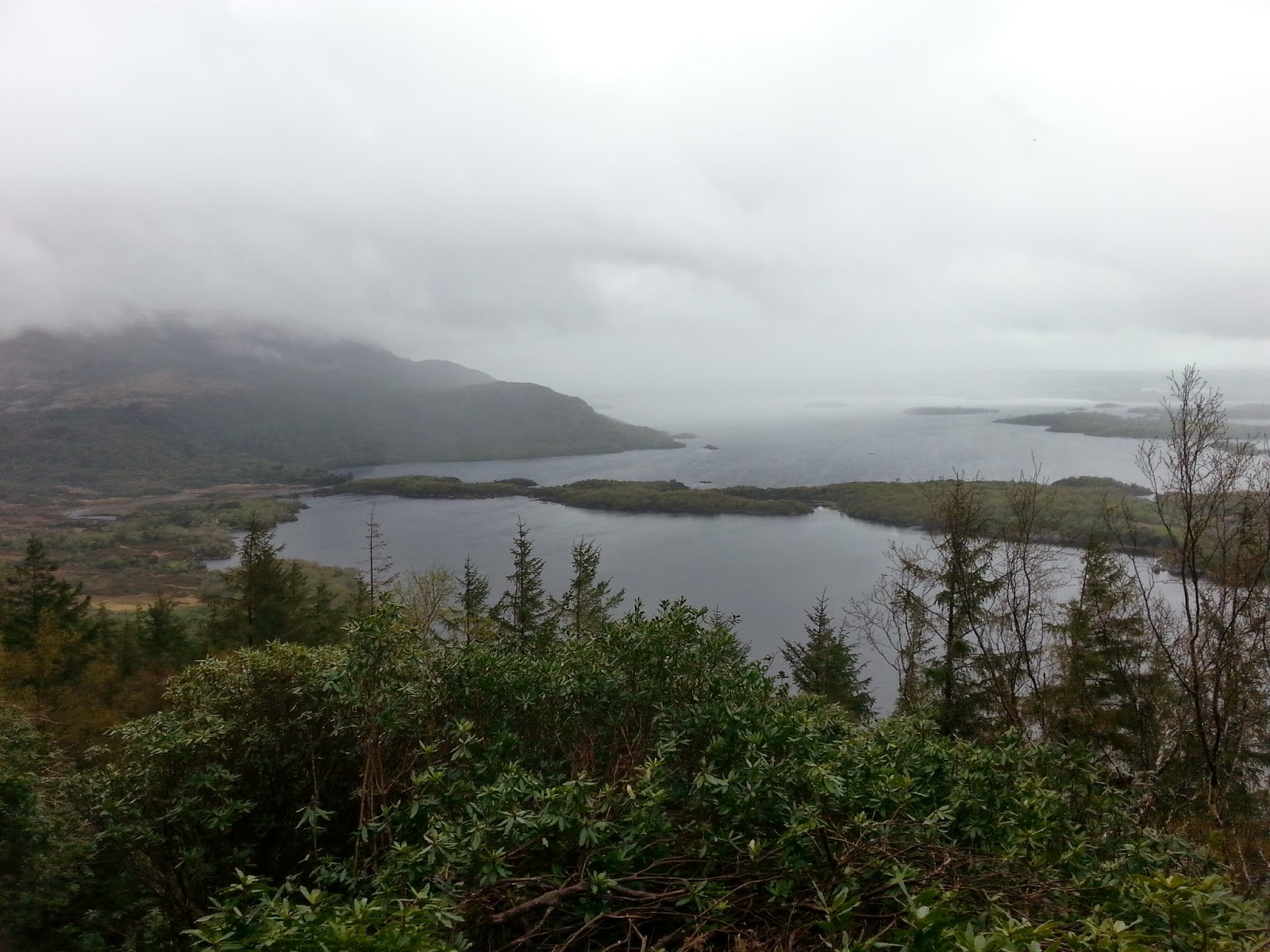
 |
| From the slopes of Benlettery |

Friday dawned and we got up soon afterward and after a good breakfast we were on the road towards The Bens by 08.15 and we were ready and walking by 08.45. The target for today was the excellent Glencoaghan Horseshoe which rightly claims to be one of the finest walks in Ireland. We parked about a mile beyond the hostel at the base of Benlettery where the climbing starts. There was a chilly breeze blowing but the morning was dry and the cloud was barely touching the highest tops. Once we reached the hostel we left the road and set on up the steep mountainside. One good thing about steep ground is that height is gained quickly and soon we were enjoying expanding views across the flat boggy ground towards Roundstone and beyond. I have often pondered and discussed with friends the merits of the various places we visit and there is a semi consensus that Connemara is the most beautiful area, certainly in Ireland, and perhaps in these islands. Anyway upwards we went but soon Frank was suffering and our progress slowed. We took it one bit at a time and eventually we reached the first of the six tops on the route Benlettery which at just 577 meters is not that high but its position, soaring 560 meters over the flat expanse of bog and water that stretch away for miles to the sea, give it a grand feel and of course the way ahead is now also to be seen and the majesty of these mountains becomes even clearer.
 |
| A nice slabby section, steeper that it looks here |
 |
| The way ahead |
 |
| Typical ground |
 |
| Back to Benlettery |
It is hard to explain to someone who has never been here how these mountains which reach only just over 2000 feet can be described as majestic yet I can think of no better word for them. They are arranged in a sort of starfish shape with the highest (Benbaun 729 mtrs) at the center. The ones on the southern side on which we were walking today have steep flanks and are predominantly rocky in nature which is in such a contrast to most of the rest of the country and are made of Quartzite. The only other mountains that I have seen in these islands that can compare are The Coulins in Skye although those are considerably higher and sharper. It is a real treat to walk on ground that is peat free but the rocky ground poses its own difficulties as well. Anyway the next top, Glengower, is easy to reach with only a short drop and an easy ridge to its 664 mtr top. From here there is a steep descent to just 450 mtrs before a stiff climb to the summit of Benbreen 691mtrs. From here there is a broad rough rocky undulating ridge that goes in an L shape before another steep drop to the col under Bencollaghduff. Along here we were treated to the full force of the stiff wind and we even had some snow in our faces to keep us focused. By now Frank had recovered somewhat and we were able to make steady progress. Once we reached the Col we were both glad to have a good bite to eat and relax and soak in the stunning views. After lunch we climbed the mostly easy ridge to the Bencollaghduff 696 mtrs summit but we managed to enjoy a couple of scrambles up some steep rocky banks that presented themselves. Another long descent of just over 200 mtrs followed before another steep climb to the highest point of the day Bencorr 711 mtrs which offered another great place to rest a while and enjoy the stunning views in all directions. Down again before the final pull to the last top of the day Derryclare. A long but easy descent on mercifully springy turf saw us arrive on the valley floor and a nice walk for a couple of kilometers on a beautiful little lane saw us back at the car. It had been a great day.
 |
| Looking back to Glengower |
 |
| Looking back and across from Bencorr |
 |
| The first half of the route |
 |
| Towards Benbaun |
 |
| Towards Bencorr |
 |
| Towards Roundstone |
 |
| Glencoaghan |
Saturday March 29th;
Today was supposed to be a bad weather day and indeed when we left to head once again to "The Bens" the air seems pregnant with moisture and the cloud base was down to about 500 meters. We had decided to do the Gleninagh Horseshoe which would again see us climb Bencorr and Bencollaghduff but in the opposite direction and culminate in climbing Benbaun which I had never done. Whereas yesterday was a big outing of over sixteen kilometers with over 1600 meters of ascent today's outing was a few kilometers shorter and and had a few hundred meters less climbing. We parked just up the lane off the main road at the base of Knockpasheenmore. We opted to do the horseshoe in a clockwise direction as that would leave the easier descent and would finish right at the car. We walked in the lane a short way before setting off across the flat expanse of bog to the base of Bencorrbeg (577 mtrs). Here we were faced with a steep 500 meter climb but towards the top we were able to find nice scrambly bits that made things more interesting. Frank was doing better today as well so there were less stops en-route. Across the valley the Maumturks looked wonderful and the weather looked like it was getting better as well. Before we reached the rugged top we were enveloped in the mist but before we left the cloud had lifted and stayed high for the remainder of the day. It was a little less windy and a few degrees warmer as well so we were well happy. Now we were able to enjoy the view along the rocky ridge that stretches onward to Bencorr. To reach the summit we had to do a short out and back from point 690 before descending steeply and then rising another couple of hundred meters more easily to the summit of Bencollaghduff where we enjoyed a bite of lunch. Though we had been on these two peaks yesterday, today had a different feel to it since we approached both from different directions.
 |
| The Maumturks looking moody. |
 |
| Heading across the bog towards Bencorrbeg |
 |
| Looking across at Letterbreckaun |
 |
| Too old for selfies |
 |
| Frank enjoying some choice scrambling |
After lunch another long descent to the lowest pass on the route Maumina which is a truely lovely viewpoint but as it is only at just over 400 meters it meant that we were left with over 300 meters to reach the top of Benbaun which at 729 meters if the highest on the range. Here the nature of the mountains change. Now the rough Quartzite underfoot is replaced with green grassy slopes that are much easier on these ageing knees. As we rose higher the views got better and better and the impressive northern flanks of Bencollaghduff are revealed. We made good progress and before long we were marveling at glorious vistas in every direction. Fine mountain scenery surrounded us and fed the senses and beyond the backdrop of the Atlantic framed everything. There was a lovely remote feel to the place and it was easy to understand why people travelled from all over the world to visit here. After a suitable pause to try and take it all in we set off in a northwest direction, steeply at first and then gently along the boggy plateau to Knockpasheenmore where we descended the final 400 meters on wonderful springy dry grassy ground to the car. It had been another wonderful day in this most special of places. We retired to Clifden for the night and decided to do a hike on the Maumturks the following day.
 |
| On the slopes of Benbaun looking at Bencollaghduff and Benbreen |
 |
| Summit panorama |
 |
| Thr ridge up from Bencorrbeg |
 |
| Benbaun and beyond |
 |
| Down in Maumina |
 |
| I called this rock "The Watchman" |
 |
| Towards Diamond Hill |
 |
| Carrot Ridge and other rock routes on Bencollaghduff |
 |
| The stunning Inagh Valley |
Sunday March 30th;
We awoke to beautiful blue skies and the promise of the best weather of the trip. Unfortunately Frank decided that two days was as much as he wanted to do as he was going on holiday to see his girlfriend in a couple of days and he didn't want to have any aches and pains so I was left with little option but to return home. I was pretty gobsmacked and disappointed and it was a pity to merely be driving past the mountains on the way back. I dropped him off and I had intended to perhaps go for a run at home but as the day was so nice and it was still before midday I took one look at the Galtee mountains and decided what the heck, I still had time for another climb. So I made the thirty mile detour and headed to the Clydagh Valley Horseshoe. Though they are a fair bit higher the difference between "The Bens" and the Galtees goes much further. While the Bens are predominantly rocky, the Galtees are almost entirely blanketed in peat and are of a much more rounded and less rugged nature. That's not to say they don't have their own charm and while I have been a bit remiss in the frequency in which I visit them I still get a buzz every time. Today was no exception and as I crested the hill by Lisvarinane the whole of the northern side of the range looked wonderful.
I arrived at the carpark and quickly changed and I was on the move at 12.45. I hadn't gone very far when I saw the first signs that there was a change in the weather coming. The blue sky had been replaced by a high, thin, steely grey layer of cloud that had seemed to creep overhead imperceptibly. Sure enough before long some cloud started to gather on the summit of GaltyMor (919 mtrs) and this gradually expanded and lowered to cover GaltyBeg at 800 meters. Ah well I was here now and a day on the hills isn't all about great views so I pressed on. I was moving well and the summit of Slievecushnabinnia at 766 meters soon arrived. Though I was well above the height of Benbaun it certainly didn't feel like it and the nature of the terrain was such a contrast. An easy climb up and around the rim of the large coum of Lough Curra saw me reach the final pull to the top of GaltyMor. Any views had long since dissappeared and I had been in the cloud since the 700 meter contour. The rain had also arrived with the cloud but I was still enjoying myself. I had no reason to stop and I set off from the summit towards GaltyBeg. I dropped quickly but managed to drift off the true way and eventually realized that I was on unfamiliar ground. I stopped and brought out my compass and realized that instead of heading in a northeast direction I had managed to swing around to a southwest direction and was going down the wrong side of the mountain. I finally did what I should have done at the summit and took a bearing and set off in the correct direction. Still no harm done and I was soon back on track and struggling up through the terribly mucky ground to GaltyBeg. Here I sensibly kept the compass handy and set off in the direction of Cush. A long drop and a tiring couple of hundred meter climb to my final top in the ever worsening weather meant I was glad to finally arrive back down at the car. I was pleased that I had done the round in well under four hours but all I wanted to do was change into dry clothes and head home. It hadn't been what I was expecting to get done today but it was a worthy workout and overall it had been a great few days.
 |
| The Clydagh Valley Horseshoe on the Galtees, quite different |